WRIAD (White Rim in a Day)
Day use backcountry permit is required.


Caution! We do not provide turn-by-turn directions in our GPX files. Those are auto-generated by your bike computer and are usually less than 70% accurate. Learn more.
For help loading a GPX file onto your bike computer, go here.
DownloadHighlights & Remarkable Spots
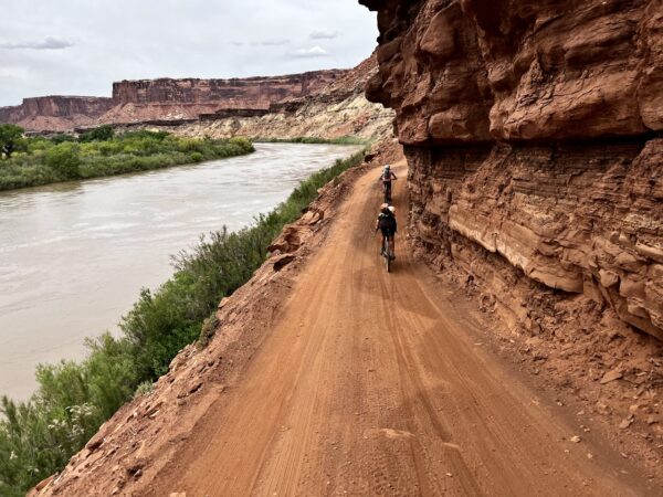
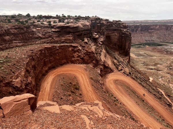
Shafer Trail Switchbacks / ~ Miles 10.5 to 13
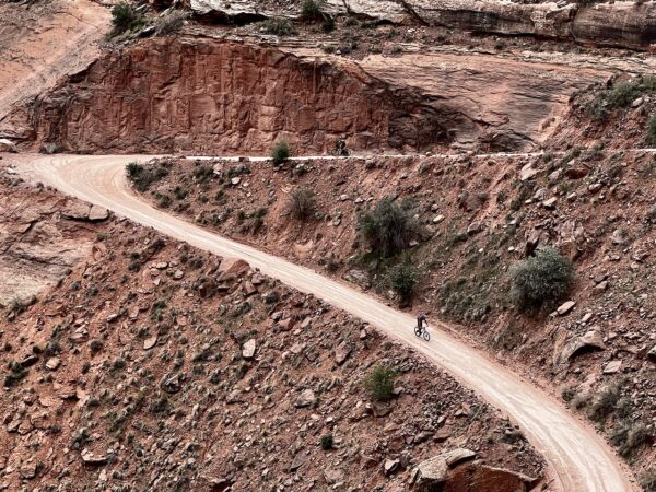
The beginning of the Shafer Trail was a footpath to move cattle up and down the canyon. It name from the Shafer Brothers who ran cattle up and down it at the turn of the century. However, with the Uranium boom in the early 1950’s years, the trail was widened out to a “road”.
Colorado River Overlook / ~ Mile 16.5
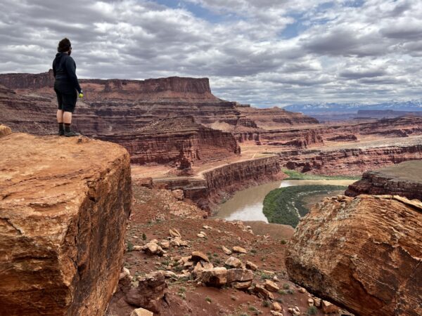
Bike out to it! It is a short 1/4 mile diversion.
The Colorado River and the surrounding canyons were home to many different indigenous peoples dating back to over 10,000 years ago, notably the Fremont culture which flourished from the 7th century to the 13th century. The Fremont were semi-nomadic people who lived in pithouses and are best known for the rock art on canyon walls and in sheltered overhangs. The recent indigenous cultures included the Utes, Paiutes, and Navajos. [National Park Service]
Musselman Arch / ~ Mile 17
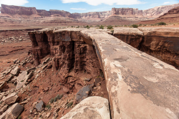
Walk out to it, but do not walk on it!
Ross Musselman and his brother ran a dude ranch in the Moab area in the 1940s in addition to a successful guiding operation. He was responsible for many people getting their first glimpses of this gorgeous, expansive territory. This arch is also known as the Walking Bridge. Did not discover the arch. Kind of strange that and innocuous that an arch is named for him. [Photo Credit: Greg Willis]
Murphy Hogback / ~ Mile 52
Views, Views, Views! (Picture from the summit of the Hogback.)
A hogback is a ridge with a sharp summit, and steep sloping sides. Murphy’s Hogback is named for the Murphy’s who were cattleman of the area in the late 1910s.
Turks Head Tower & Black Crack / ~ Mile 59.5
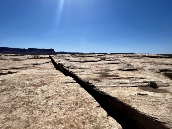
Turks Head Tower, across the river, marks the site of black crack. Black crack is a 1700 foot long fracture that is about a foot to two feet wide and very, very deep. It about a 5-minute walk out to the black crack, but it is an amazing sight to see!
Green River / ~ Miles 60 to 85
The status of the Green River as a tributary of the Colorado River came about mainly for political reasons. In earlier nomenclature, the Colorado River began at its confluence with the Green River. Above the confluence, Colorado was called the Grand River. In 1921, the U.S. Representative of Colorado petitioned Congress to rename the Grand River as the Colorado River over the objections of representatives from Wyoming and Utah, which noted that the drainage basin of the Green River was more extensive than that of the Grand River, although the Grand carried a higher volume of water at its confluence with the Green. On July 25, 1921, the name change was made official in House Joint Resolution 460. [Wikipedia]
Potato Bottom Cowboy Camp & Trunk / ~ Mile 72.5
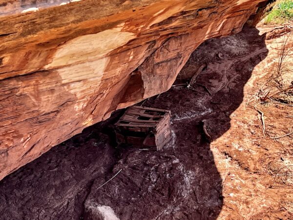
Under a rock overhang, you will see and old chest. It was supposedly used to keep supplies for cattleman who frequented the area. This site was the last good watering hole and along the Green River before heading up river.
Use these GPS coordinates to find the location: 38.41744, -110.00191
Hardscrabble Hill (Petrified Wood) / ~ Mile 74
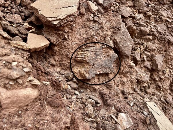
This section is sometimes called Walker Cut, for Mark Walker who widened this narrow cattle trail with dynamite in the 1890s. Scrabble is from Middle Dutch “encompassing the concepts of barrenness, effort at the edges of one’s ability, and a desperate groping around to find purchase.” Expect exactly that.
From Hardscrabble Hill you cut through the Chinle Formation of rock. This layer contains vast amounts of petrified wood and volcanic ash. We found several pieces of petrified wood in the area. One piece directly on the climb.
Green Streaking of Uranium Layer / Miles 77 to 85
This section of trail highlights a horizontal green streaking layer with red and purplish hues of siltstones and sandstones. This is the Chinle Formation, dating back 208 to 245 million years. Uranium was found in the lowest part of this layer called the Moss Back Member. This is the layer that was mined during the uranium boom era of the 1950s.
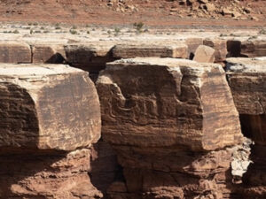
Ancient Granary / Mile 78.1
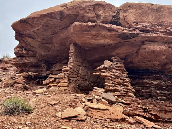
This is an easy to miss highlight. Just up the wash and a short hike in (~ 1/4 mile) is an ancient granary (~ 1200 to 2000 years old) that was used by the native american people who inhabited the area to store corn, beans, and squash. Corn provides a tall stalk for the beans to climb, while the beans fix nitrogen in the soil, benefiting both themselves and the other plants. The squash plants, with their broad leaves, create a natural ground cover that helps suppress weed growth, conserves moisture, and shades the soil, reducing evaporation.
This is also a great spot to rest and catch a bit of shade!
Lat/Long: 38.462974, -110.004237
Upheaval Wash / ~ Mile 78.5
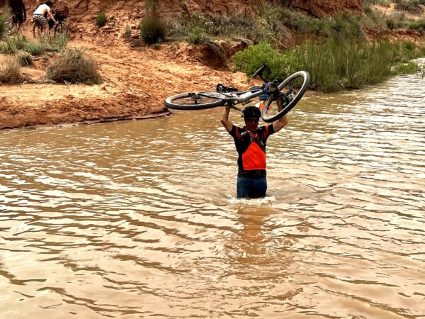
This can be one of the trickiest parts of the ride. The wash floods in from the Green River. In 2023, ~ May 9 the Green River flow was at 21,000 cubic feet per second (CFS). We crossed with the water just below waist level. Later, that month the flow was at 26,000+ CFS, making the crossing almost impossible. Note, the bottom of the wash can be slippery and develop soft quick-sand type depressions. You can check the flow here.
Cowboy Camp / ~ Mile 81
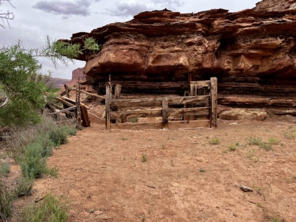
Here are the remnants of an old cowboy camp and corral. Another great spot to rest and get out of the sun! It is interesting to note that circular feature of the rock walls making up the camp that provide shade cover most of the day. Just beyond this camp, look up and to your right for the remnants of an old uranium mine.
(Note – if you know of more history regarding this camp, we would love to hear about it. Drop us an email, using the address at the bottom of this page.)
Mineral Bottom Climb / ~ Mile 85 to 87
Just west of the route at mile X, lies Mineral Canyon, site of a small uranium mine opened by the Excalibur Mining Co. in the early 50s during the uranium “gold-rush” in the 4-corsners region of Utah, Colorado, New Mexico and Arizona (ie. the Colorado Plateau). As promising sites were identified, the arduous task of cutting dirt roads and bringing in heavy excavating machinery to begin the mining process commenced. Thus, the creation of Mineral Bottom road. Excalibur mine like all others in area failed to remain profitable and ultimately closed.
Mineral Bottom Road / ~ Miles 87 to 100
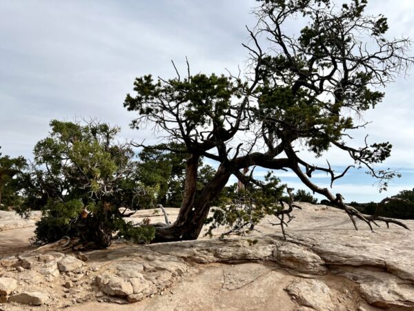
The last miles have you riding on top of the plateau. Here you will see an array of pinyon pine and juniper trees – the most common trees in the park. The trees grow very, very slowly due to extremes of heat and cold, lack of water (less than 10″ per year) and an elevation of nearly 6000 feet. A pinyon pine will produce its first pine cone at about 100 years and live to 300 years. The junipers will live to 700 years old, maybe 1000 years old.
In the picture, there is a juniper to the left and a two-needle pinyon pine to the right.
Credits & Acknowledgements
Much of the information in the Highlights Tab is sourced from these two books:
- White Rim Trail: Mile by Mile by Robb Magley
- A Naturalists Guide to the White Rim Trail by David B. Williams and Damian Fagan
When We Like to Ride This
April – May or September, with a daytime highs 60 to 70 degrees, and partly cloudy. These months will give you the most favorable conditions for heat and amount of daylight.
Terrain & Riding
The Terrain
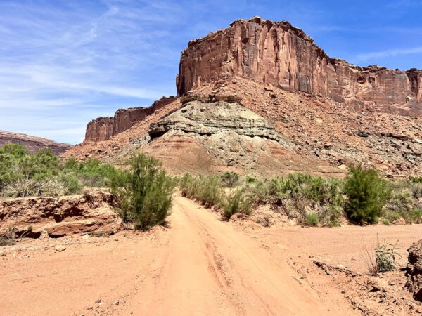
This route will take you over a variety of terrain types, challenging your endurance and technical prowess as a cyclist. The trail surface varies from hard-packed dirt and slickrock to loose, gritty sand, and the occasional rocky section that will test your bike handling skills.
You start with a heart-pounding descent from the Island in the Sky mesa, dropping over 1,000 feet into the layered depths of the canyon. This initial downhill is a thrilling rush of wind and speed, but don’t let it lull you into complacency. The White Rim trail has a way of introducing dramatic changes in terrain when you least expect them.
The trail mostly undulates, dips, and rises, mimicking the rhythm of the land. But just when you’re getting used to the rhythm, the trail will throw a curveball – a steep, grueling ascent or a sudden, sharp switchback. It’s a demanding ride, but the panoramic views of towering red cliffs, deep river canyons, and vast expanses of desert will make every pedal stroke worth it.
What You Will See
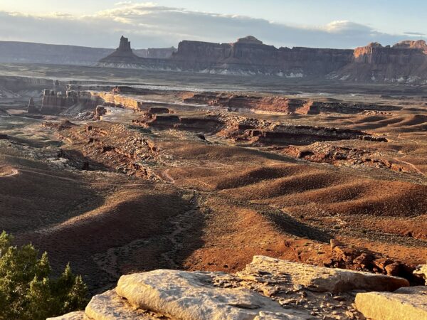
As you traverse the mesmerizing landscape of the White Rim trail, you’ll be treated to an astonishing array of natural wonders, geological formations, and breathtaking vistas that will leave you spellbound. This remote and rugged terrain offers a unique opportunity to immerse yourself in the untamed beauty of Canyonlands National Park.
One of the most iconic sights along the trail is the Colorado River, winding its way through the vast canyons below, carving out intricate patterns in the red rock over millennia. You’ll also marvel at the Green River, where its confluence with the Colorado River creates a striking contrast of colors and textures in the landscape.
The trail itself skirts the edge of the Island in the Sky mesa, offering jaw-dropping views of the surrounding canyons, buttes, and mesas that make up this geological masterpiece. You’ll pass by famous landmarks such as the aptly-named Monument Basin, where towering sandstone monoliths stand sentinel, and the mysterious Candlestick Tower, reaching towards the heavens like a beacon in the desert.
As you ride through this ever-changing terrain, keep an eye out for the various natural arches that adorn the landscape, like the impressive Musselman Arch, which spans over 100 feet across a deep chasm. Don’t forget to take a moment to appreciate the smaller wonders too – the vibrant desert wildflowers, the hardy juniper trees, and the intricate cryptobiotic soil crust that supports the delicate ecosystem of the region.
Whether it’s the grand vistas, the unique rock formations, or the subtle nuances of the desert environment, the White Rim trail offers a visual feast that will inspire and awe every adventurous soul who dares to venture into this untamed wilderness.
The Start
Dirt parking lot at the intersection of Mineral Bottom road (the road you finish on) and state highway UT 313.
Food & Water
- None. You must be self-sufficient!
Route Notes
Day use backcountry permit is required. Also, a National Park entrance fee required; this can be paid at the park entrance (@ ~ mile 8).
Know before you go. Check the National Park Service alerts. We have seen first hand where travellers have had to turn around 60 miles into their journey, with the sun going down, and with limited food and water.
Stay on the trail! In many, many areas when you look down at the ground you will see tiny black mountain ranges growing out of the red dirt. That is cryptobiotic soil, also called, biocrust. It is the glue that holds everything together, is super fragile, and incredibly important to the “health” of the landscapes and ultimately the animals you see. It is made out of bacteria, lichens, and mosses. If you step on it and crush it, it can take 50 to 250 years to grow back. If you do walk off the White Rim road, do so on designated trails, slickrock, or in washes. To learn more watch this quick 3-minute video.
By riding the White Rim Trail you will have an impact on wildlife, particularly the Desert Bighorn Sheep, even if you don’t spot them. Back in 1975, the number of bighorn sheep in Utah was less than 1000, largely due to disease, trophy hunting, and competition from domestic sheep. However, thanks to conservation efforts, the population has increased to around 3000 sheep today, with 10% of them residing in Canyonlands National Park.
What can you do to minimize your impact? Bighorn sheep are particularly sensitive to loud noises. Do not yell or whoop on your adventure, even though we all want to do so! Use conversational voices only.
Give them their distance, 100 to 200 yards minimum. If you encounter them at a closer distance, give them time to move on. This may mean stopping and putting a foot down and waiting for 5 to 10 minutes. If you do need to pass by, ride as a tight group in a quick (not fast!), expedited fashion.
Do not expect to filter / treat water from the Colorado or Green Rivers, it is a silty brown mess!
Use toilets when available. Know where they are. Pee in the road, not the bush. Learn why in this podcast all about pee, poo, and backcountry hygiene.
On steep sections of the trail like the Shafer Switchbacks, Murphy Hogback, Hardscrabble Hill and the Mineral Bottom Climb, uphill traffic has right away, regardless of vehicle type (jeep, motorcycle, bike). On these steep uphills it is very difficult to get started again once stopped, thus uphill momentum is key to gaining the summit.
This route is best ridden on an adventure gravel bike, something a bit more rugged and burly than your standard gravel bike. We rode this on a Salsa Cutthroat with 2.2″ tires (tubeless + CushCore) and a 100 mm front suspension fork with lockout.
Love Where You Ride! Learn More
 The White Rim Trail in Canyonlands National Park is named after a distinctive feature in the area known as the White Rim Sandstone. The White Rim Sandstone is a prominent layer of sedimentary rock found within the park. It is composed of light-colored sandstone that often appears white or off-white in color, hence the name “White Rim.”
The trail follows the top of this sandstone layer, offering scenic views of the surrounding canyons, cliffs, and mesas. The contrasting white color of the sandstone against the red and brown hues of the surrounding rocks makes it a visually striking feature, which likely contributed to its name.
Geology on the White Rim is straightforward, there are only layers of sedimentary rock. The oldest visible layer is the old Cedar Mesa Sandstone from ~245 to 286 million years ago; the youngest layer is the Navajo sandstone from ~144 to 208 million years ago.
Videos
The Ride! White Rim in a Day
A quick 5-minute video of what to expect on your ride!
The White Rim Road
Know before you go! This is a must watch. It has helpful tips and advice to help you plan your trip and Leave No Trace while out in these pristine areas.
Biocrust – Don’t step on it!
Ecologist Kristina Young talks about the importance of Biocrust to the Moab desert. It's the glue that holds everything together! Learn more in this 3-minute video.
The Desert Bighorn Sheep
Learn a bit more about the majestic, and endangered, Desert Bighorn Sheep in this 3-minute video by the Park Service.
Keep it Local! Learn More

 Behind every route is scouting, mapping, storytelling, and a whole lot of pedal power.
Have you ridden this route? Got a question? Join the discussion!