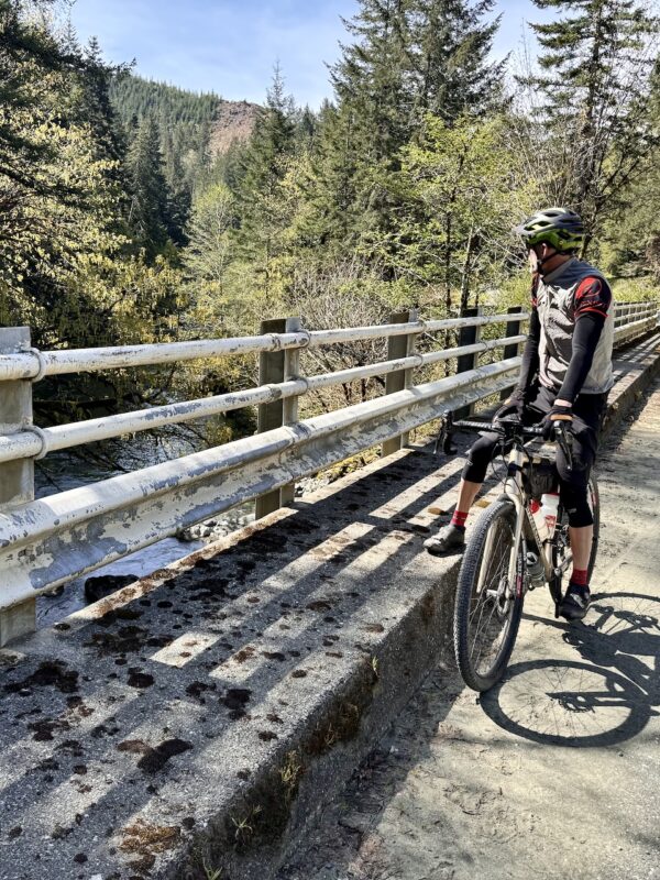
Wildhorse 8


Caution! We do not provide turn-by-turn directions in our GPX files. Those are auto-generated by your bike computer and are usually less than 70% accurate. Learn more.
For help loading a GPX file onto your bike computer, go here.
DownloadHighlights & Remarkable Spots
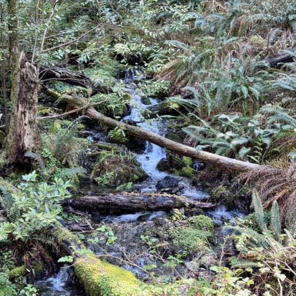
Hunter Creek / ~ Mile 2
At mile 2 you cross Hunter Creek, further in the ride you’ll pass through Hunter Creek Bog, the headwaters of Hunter Creek. What is a bog?
Bogs occur where the water at the ground surface is acidic and low in nutrients. A bog usually is found at a freshwater soft spongy ground that is made up of decayed plant matter which is known as peat. In contrast to fens, they derive most of their water from precipitation rather than ground or surface water.Water flowing out of bogs has a characteristic brown colour, which comes from dissolved peat tannins. In general, the low fertility and cool climate result in relatively slow plant growth, but decay is even slower due to low oxygen levels in saturated bog soils. Hence, peat accumulates. Large areas of the landscape can be covered many meters deep in peat.
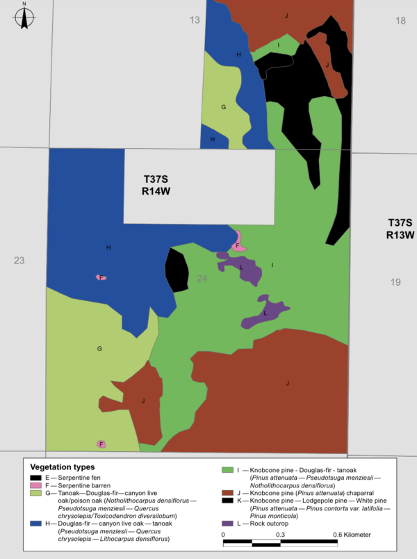
Hunter Creek Bog ACEC / Miles 6 to 8
Areas of Critical Environmental Concern (ACECs) are designated locations that require special management attention to protect important historic, cultural, and wildlife resources, as well as other natural systems or processes, from irreparable damage.
These ACEC designations also informs the public that the Bureau of Land Management (BLM) recognizes the significant value of these areas and has implemented specific management measures to safeguard them.
Here, at this bog you will find 8 different ecosystems and a variety of special plant and animal species. Below we have highlighted several.
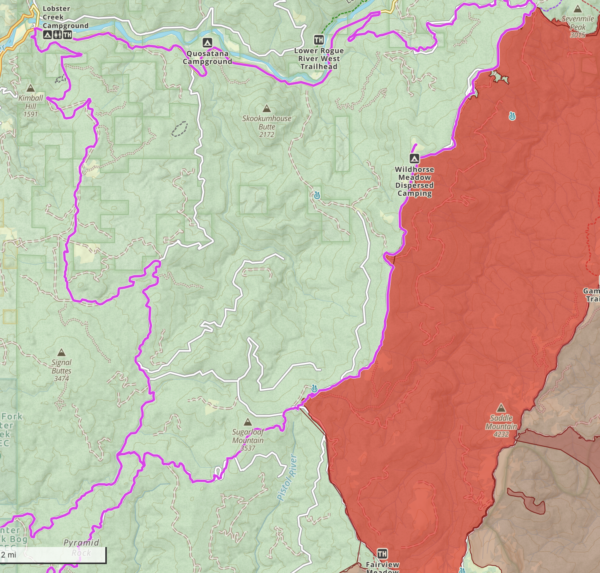
Click on the image to the left to expand the map.
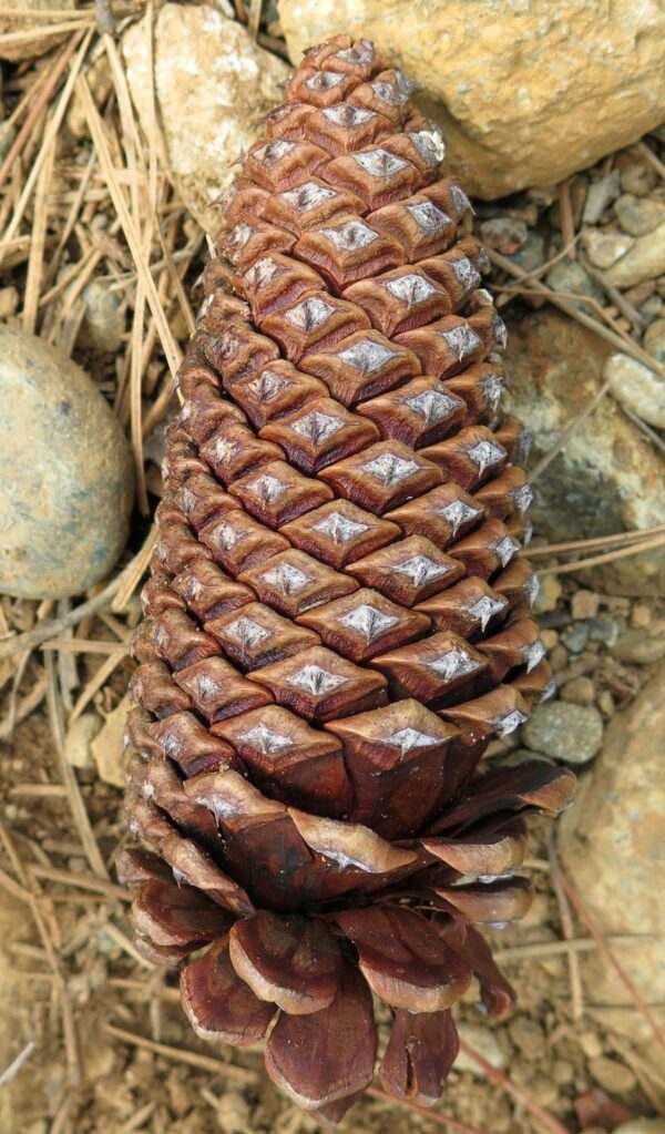
Knobcone Pine
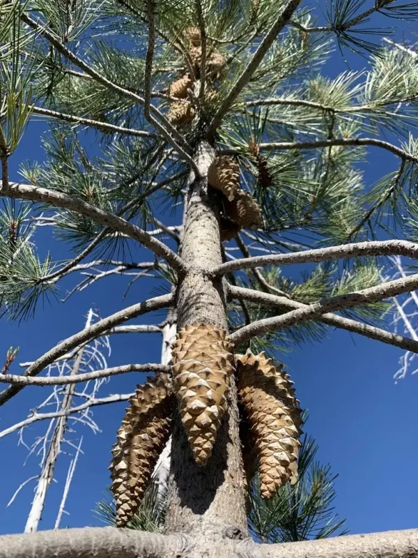
Its most distinctive feature is its serotinous cones, which remain closed and attached to the tree for many years. When fires kill the trees, cones as much as 30 years old are opened by the heat and shed their seeds. The abundant seedlings then begin a new forest.
The cones grow directly on the trunk and main branches, rather than at the ends of branches like other pine trees.
Knobcone pines start producing cones at a very young age, sometimes as early as 2-3 years old. Knobcone pines have a relatively short lifespan, typically 75-100 years.
The tree often grows in an irregular or asymmetrical shape, especially in windy areas.
Jeffrey Pine
One of its most distinctive features is the sweet, vanilla-like scent of its bark, especially when warm. This aroma is often described as reminiscent of butterscotch or pineapple.
Jeffrey pine cones are larger than those of many other pine species, typically 5-10 inches long. The cones have inward-curving prickles, leading to the saying “gentle Jeffrey” ,as opposed to the sharper prickles of the similar-looking Ponderosa pine. It was once considered a variety of Ponderosa pine but is now recognized as a distinct species.
Jeffrey pines have thick bark that helps protect them from low-intensity fires, an important adaptation in their natural range.
Coast Live Oak
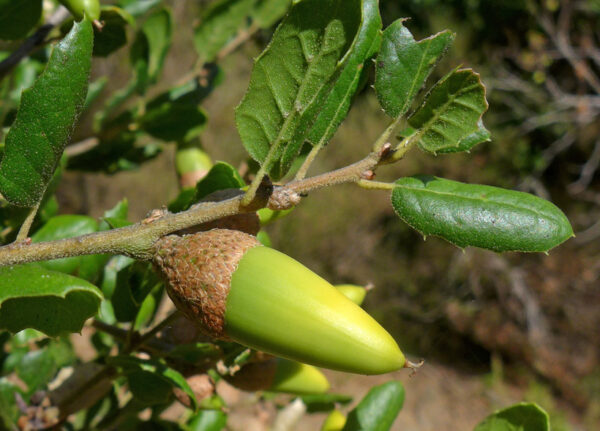
Unlike many oak species, Coast Live Oak retains its leaves year-round. The leaves are oval with spiny edges, which is unusual for oaks.
It’s well-adapted to the coastal climate, tolerating salt spray and fog. It also has a deep root systems that helps them survive dry periods.
These trees can live for several hundred years.
Johnson's Hairstreak
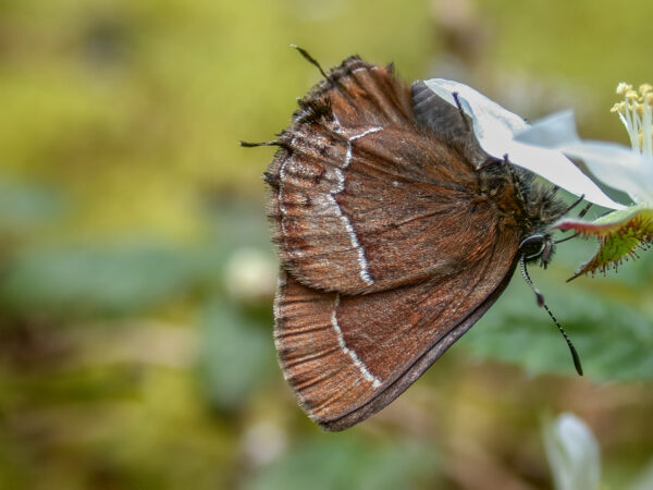
This rare and unique butterfly species is dependant on old-growth forests. Its larvae feed exclusively on dwarf mistletoe, a parasitic plant attaching itself to old growth Douglas Fir and Ponderosa Pines. The butterfly’s life cycle is synchronized with its food source. Adults typically emerge once a year, flying from late spring to early summer. This timing coincides with the growth of new mistletoe shoots, ensuring an ample food supply for the next generation of larvae.
Unlike many butterflies that are commonly seen near the ground, Johnson’s Hairstreak spends most of its time high in the forest canopy, making it difficult to observe and study.
Mardon Skipper
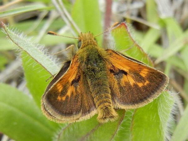
This species is only in specific regions of the Pacific Northwest. Mardon skippers inhabit meadows. Larvae feed on native fescue (grass). Its presence can indicate the health of native grassland ecosystems.
Loss of grassland habitat due to climate change and degradation of remaining grasslands by invasive plants are harmful to mardon skippers. Populations appear to be declining.
Adults typically fly for only a short period each year, usually in late spring to early summer.
Gasquet Manzanita
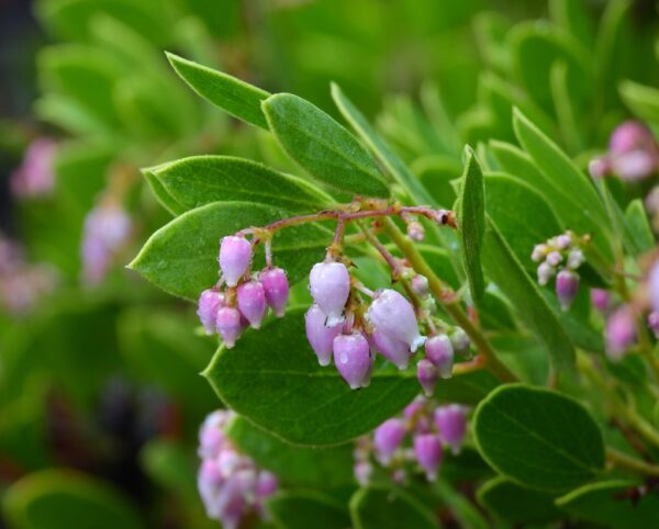
The Gasquet manzanita is a unique and rare species of manzanita. It’s found only in a small area of northwestern California and southwestern Oregon.
Unlike many manzanita species, the Gasquet manzanita has bristly, hairy stems and leaves, giving it a distinctive texture.
It typically grows in serpentine soils, which are challenging for many plants due to their unique mineral composition. This demonstrates a unique ecological adaptation.
Elegant Gentian
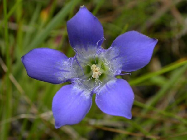
The Elegant gentian grows exclusively in serpentine wetlands of southwestern Oregon and northern California. The total number of individual plants is low with about 66 known occurrences. Can be found in the same areas as Cobra Lily’s (see below).
The plant’s flowers are notable for their deep blue color and tubular shape. These characteristics are particularly attractive to bumblebees, which serve as important pollinators for the species.
Stansell's Daisy
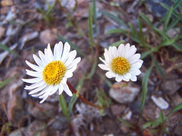
Look for Signal Buttes to your left.
Near here is the largest known population of Stansell’s Daisy. This daisy species is endemic, meaning it naturally occurs only in this area. Specifically, it is found in just two small locations within the Rogue River-Siskiyou National Forest.
The daisy was first identified by Veva Stansell in 1982, a life-long Curry County resident and retired U.S. Forest Service botanist. She is widely-known and respected for her contributions to understanding and conserving botanical resources of the Siskiyou Mountains.
Biscuit and Flat Fires / ~ Miles 16 to 28
On July 13, 2002, a series of electrical storms passed over southwestern Oregon’s Siskiyou Mountains. That afternoon’s barrage of lightning strikes ignited five separate fires within the vast Kalmiopsis Wilderness. By early August the fires had grown together into a single, massive, and expanding conflagration that burned well into October. The U.S. Forest Service dubbed it the Biscuit Fire. With a burned area totaling just forty acres shy of a half-million acres, the Biscuit Fire is believed to be Oregon’s largest forest fire of record.
Parts of the area re-burned with the 2023 Flat Fire. Ignited at about 5:51 PM PT on July 15, 2023, the fire was human caused. As of October 31, 2023, the fire had burned 34,242 acres and was 100% contained.
Wildhorse Lookout / ~ Mile 23
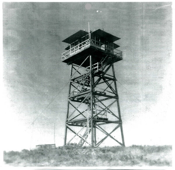
Wildhorse Lookout has a rich history dating back to 1929 when a fireman’s cabin was first constructed on the site.
In 1942, during World War II, an Aircraft Warning Service (AWS) cabin was added. The AWS was part of the Oregon coastal defense strategy. Civilian volunteers acted as airplane spotters, manning over 500 observation posts across western Oregon. The service, supervised by the Army’s Fourth Fighter Command, aimed to track all aircraft in the area to provide early warning of potential enemy attacks. At its peak, over 28,000 trained volunteers participated, working 4 to 6 hour shifts to maintain 24-hour vigilance. The system included “filter” centers where reports from observation posts were collected and processed. Learn more of this fascinating history here. (Picture from 1947.)
Horse Sign Butte / Kamliopsis Wilderness
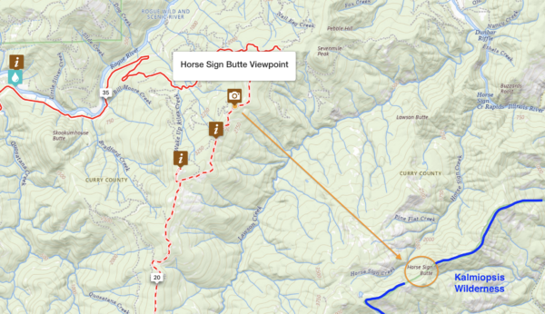
The Kalmiopsis Wilderness is renowned for its exceptional plant diversity, hosting over 350 species of plants and trees. The area’s namesake plant, Kalmiopsis leachiana, is an endemic shrub discovered in 1930 by botanist Lilla Leech in the Gold Basin region. This plant is particularly significant because:
(1) It’s a living relic from before the ice age. (2) It’s considered the oldest known member of the Heath family (Ericaceae).
Click on the map for more detail.
Rogue River / ~ Miles 34 to 42
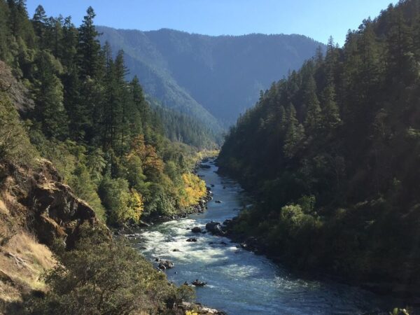
The mighty Rogue River flows 215 miles from its headwaters in Crater Lake National Park to the Pacific Ocean in Gold Beach, Oregon. It has two Congressionally-designated National Wild and Scenic sections. The 84-mile long Wild & Scenic Lower Rogue River was one of the original rivers designated under the Wild & Scenic Rivers Act of 1968, and carries that title from the mouth of the Applegate River to the Lobster Creek Bridge (~ Ride mile 42). The Wild Section of the Lower Rogue River is one of the most popular whitewater runs in the world.
More information at Wikipedia.
Francis Shrader Old Growth Trail / ~ Mile 44
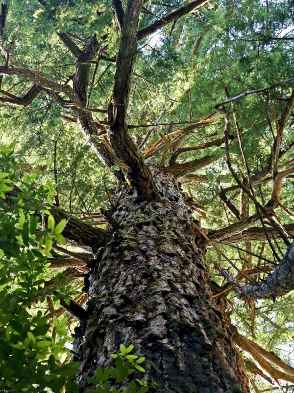
The one-mile loop trail winds through a forest of Douglas firs and Port Orford cedars. The tallest trees top out at 250 feet tall, at 600 to 1000 years old.
It’s home to the Laddie Gale Tall Fir. Now standing at roughly 220 feet tall and 10 feet in diameter, the tree is named in honor of Lauren “Laddie” Gale, a member of the 1939 University of Oregon’s men’s basketball team that won the very first NCAA tournament. With a height advantage against the other teams, the Webfoots (not yet the Ducks), were nicknamed the “Tall Firs.”
Grab a pamphlet at the trailhead and follow the numbered posts along the trail.
[Ref: Oregonian]
Cobra Lily (California Picture Plant) / ~ Mile 61
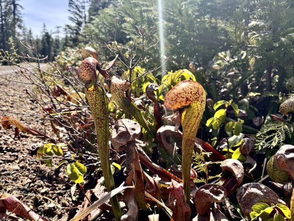
The Cobra Lily is a carnivorous plant native to northern California and southern Oregon. It traps and digests insects for nutrients using its distinctive hollow leaves that resemble a cobra’s head. The plant employs clever tactics to catch prey, including a forked leaf that appears to be an exit but leads nowhere, and translucent patches that confuse trapped insects. Inside the pitcher-like structure, downward-pointing hairs make it difficult for prey to escape. Unlike most carnivorous plants, the Cobra lily lacks digestive enzymes and instead relies on bacteria to break down its catch. Despite its predatory nature, it doesn’t eat its pollinators, which are primarily small flies.
Flycatcher Spring / ~ Mile 61.5
Here the water percolates and bubbles out of the ground. Unlike creeks fed by snowmelt or rainwater, spring water comes entirely from beneath the earth’s surface. This underground origin results in very pure, clean water due to natural filtration through soil and rock. The water emerges cold from its deep source and typically maintains this cool temperature throughout its course. Unlike rivers or creeks that rely on gravity to flow downhill, spring water is pushed up and outward by underground pressure. This allows springs to flow across flat terrain where typical surface-fed streams might not persist. Springs can also maintain consistent water levels even in dry conditions, as they’re less dependent on surface precipitation. [Wikipedia]
Credits & Acknowledgements
This ride guide is funded in part by the Oregon Coast Visitors Association.
When We Like to Ride This
When we rode this in mid-April, the snow had just melted out at the higher elevations. Probably closes down in mid-November.
Terrain & Riding
Hunter Creek Sector / Miles 0 to 12
- Use the start as documented, it gives you ~ 1.5 miles of spinning (paved and flat) before beginning a 4 mile climb that averages 7% with maximum gradients of 15%.
- Just before mile 2 cross Hunter Creek. Scenic view.
- The first part of the climb is through private timberlands, however the road is public access. On this sector, you may encounter open grazing.
- Overall the gravel road is in good shape, however there are a few landslips where the road drops by a foot or so.
- Most of the climb is through mid-growth forest. Pine, cedars, doug fir, red alders, pacific Madrone, tanoaks, and pines. We found this forest to be incredibly unique and diverse and unlike classic Coast Range forest that you would expect here.
- At ~ mile 7, when you come to a break in the climbing, to your left is an outbreak area of sudden death oak. Stay on the road, do not wander into the forest and look. One way sudden death oak is spread is via soil transfer on shoes or tires. Here you also get vista views of logging lands and the coast.
- At ~ mile 11 pick up Hunter Creek again (to your left). This is just before the connector of the lower loop to the top loop of the Figure 8. The connector road has some big, big Doug Firs.
Wildhorse Sector / Miles 12 to 28
- Beyond the connector there still is another 2400 feet over 12 miles, however the terrain is undulating. The connector marks about the halfway point in the opening climbing segment, from Hunter Creek Bridge to Wildhorse Lookout. The total climb is 4700 feet of gain over 21 miles.
- Along this sector, you will be above 2500 feet elevation. There are vista views to the west to the coast and to the east to the town of Agness along the Rogue River. The forest is mostly ponderosa pine and doug-fir. At the Elko camp area, ~ mile 14, there is really beautiful stand of old growth doug-firs.
- At ~ mile 22.5 there is the short deviation (0.5 miles) to the left that leads to Wildhorse Lookout. Go!! There are great views in all directions. The road leading up to lookout is rugged, and some may need to do a bit of hike-a-bike.
Wildhorse Descent / Miles 28 to 35
- From the lookout descend on gravel 1200 feet (average gradient of 4.5%) to a small paved logging road. You will pass through a burn area. Some large doug-firs (55″+ in diameter) survived the fire. Look right, and in the far distance you will see a unique looking butte, Horse Sign Butte.
- At the junction onto the paved logging road continue the descent downhill. It is a small, single-lane, twisting road with heavy tree canopy above. Watch for cracks, rough spots, and broken sectors of gravel. You will descend 2400 feet in 7 miles with an average gradient 6.5%. After making a left onto Jerry’s Flat Road, the descent continues for another 1.5 miles. This descent is through classic Coast Range forest, shaded with thick overhead tree canopy. And, it is so much fun!
Rogue River Sector / Miles 35 to 42
- This is Jerry’s Flat road, a bit of a misnomer. Over the next 7 miles you will roll up and down, with an equal elevation gain and loss of about 650 feet. The road is double lane, expect some traffic. This is also where we recommend a red blink light.
- This sector is rural, not remote.
- Just before Lobster Creek campground turn left and begin the next sector.
Croaking Frog Sector / Miles 42 to 57
- Starts with an ungodly steep pitch of 16%+. It is short, less than 0.5 miles. The next 5 miles gain 2100 feet with an average gradient of 8% in a deep, dark forest. Beautiful riding!
- At mile 44, there is the Frances Shrader Old Growth Forest and trail. Take the time to stop and explore. It is super, super cool! Make sure to get the brochure which has a lot of interesting facts and history in it.
- Once you reach mile 50 the crux of the ride is complete. There is ~ 26 miles of riding left with 2200 feet of undulating gain and 4900 feet of descent.
- Miles 50 to 51.5 are on a primitive gravel road that is not heavily travelled due to a bridge washout ahead. Here you will need to cross Frog Lake creek. In later summer the crossing was not difficult, still some wet feet though. In spring, expect higher water flows. If you uncomfortable with the crossing, backtrack to mile 38.5 and use the NF-3313 road. It will re-intersect main route at ~ mile 52.
- Miles 52.5 to 57 are on a wide, well maintained gravel road that undulates upward, gaining 700 feet, losing 400 feet.
Cobra Lily Sector / Miles 57 to Finish
- Climb the Figure 8 connector a second time. At the top, turn right this time. The Road becomes wooded and more primitive. It is a tiny primitive road. After several miles, it widens back out again.
- This is a remote, but highly scenic sector.
- Just after mile 65 return to private timberlands and begin the descent back to the start, 2500 feet over 8 miles. Be watchful of logging trucks. Remember they have right away both uphill and downhill. It is best to put a foot down and let them pass.
The Start
Dirt parking area on the northside of Hunter Creek Road.
Food & Water
- ~ Mile 37.5 / Quosatana Campground
- ~ Mile 42 / Lobster Creek Campground
Route Notes
Recommend red blinky light with rear looking radar detector for Jerry’s Flat road (~ miles 28 to 42), something like a Garmin Varia or Trek Car Back.
We recommend a personal locator beacon (i.e. Garmin inReach Device) for this ride. At times you are 15+ miles from any major road. Cell phone reception is very, very limited.
During your ride, you may encounter active timber harvesting operations. To ensure your safety, the safety of the timber workers, and to avoid conflicts, please familiarize yourself with the following guidelines .
Signs of Active Logging:
– Signage (i.e. CB channels, mile markers, etc.)
– Gates open
– Tire tracks
– Fresh gravel in-lay
– Brushing and mowing alongside the road
– Orange ribbon marking road obstacles or hazards
– NoiseWhat You Should Do as a Cyclists:
– Remember that hauling log trucks always have the right of way! Uphill or downhill.
– Move to side of road. Stop, put a foot down. Wave!
– Use lights. A flashing white front light and a red flashing rear light with radar detector (Garmin Varia, Trek CarBack)
– Do not over ride your sight lines.
– Keep your group size small and together; reducing your riding footprint.
– Listen and be observant.Lastly, when access is temporarily closed, do not “sneak through”. Logging operators are not trying to keep you out, they are trying to keep you safe. And they may keep you out, to keep you safe.
Route Options
Shorter Options
This is a figure 8 route, thus there are two inherent loops, the north loop which we call the “Lookout Loop” and the south loop which we call the “Cobra Lilly Loop”. Note that the Lookout Loop has a creek crossing. This can be avoided as we discuss below. However, in avoiding the creek crossing, you give up the Francis Shrader Old Growth Reserve.
- Cobra Lilly loop
- 30 miles, 3700 feet, 90% gravel/10% paved.
- It can be ridden either direction, however we prefer the clockwise direction based on the climbing profile and scenic return.
- The route starts at the same locations as documented here for the Wildhorse 8 (Entire Circuit) route.
- Map, GPX file ???
- Lookout Loop with Frog Creek Crossing
- 46 miles, 6800 feet, 65% gravel/35% paved.
- It can be ridden in either direction, however we prefer the clockwise direction such that the steep 20% gradient near the Francis Shrader Old Growth Reserve is downhill, not uphill.
- This route starts at the Lobster Creek Campground and Day use area. Start Lat/Long: 42.501880, -124.295445
- Map, GPX file ??
- Lookout Loop without Frog Creek Crossing
- 44 miles, 6000 feet of gain, 60% gravel/40% paved.
- If you use the cutoff to avoid the creek crossing, we recommend the route in the counterclockwise direction. In this direction, you get an screaming fun paved descent down to the Rogue River.
- This route starts at the Lobster Creek Campground and Day use area. Start Lat/Long: 42.501880, -124.295445
- Map, GPX file.
Bikepacking Option
Ride the route as mapped and documented, there are two campgrounds along the Rogue River Sector at ~ miles
- Quosatana Campground at ~ mile 38. Water and flush toilets. First come, first serve.
- Lobster Creek Campground at ~ mile 42. Water and flush toilets. First come, first serve.
Love Where You Ride! Learn More
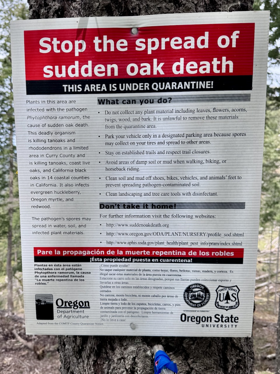
During this ride, you’ll pass through two highly sensitive areas: Hunter Creek bog (miles 6 to 8) and Flycatcher Springs (miles 61 to 62). It’s crucial that you remain on the main roads and avoid entering these areas on foot or by bike. While there may be smaller roads leading into the bog, do not use them. This is to prevent the spread of Sudden Oak Death.
Sudden Oak Death is a disease caused by Phytophthora ramorum, a fungus-like plant pathogen. Discovered in the mid-1990s, it primarily affects coast live oak and tanoak, causing significant damage to coastal forests in California and Oregon. The disease can also cause leaf blight or shoot dieback in other plants such as rhododendron, evergreen huckleberry, Douglas-fir, grand fir, and Oregon myrtle. In Oregon forests, these plants are only infected when growing very close to infected tanoaks.
P. ramorum spreads during rainy periods when spores from infected leaves or twigs are released into the air. These spores can be washed downward or carried by air currents. Importantly, humans can also spread the disease by transporting infested soil, such as wet soil on bike tires.
Videos
The Biscuit Fire (2002)
A quick 2-minute video about the 2002 Biscuit Fire, one of the largest wildfires ever in Oregon: learn how it impacted the lands and people. By Oregon Public Broadcasting.
Keep it Local! Learn More
Related Guidebook
Ridden and Reviewed by:


 Behind every route is scouting, mapping, storytelling, and a whole lot of pedal power.
Have you ridden this route? Got a question? Join the discussion!