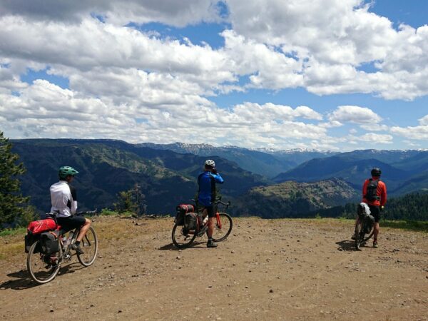
Dirty Freehub
Favorites Sign In Search
  • Search
  • Donate
  • Gravel Routes
    • Explore by Region
    • Explore by Type
    • Explore by Collection
  • All Access®
  • Stories
    • Bike Life
    • Culture & History
      • Central Oregon
      • NE Oregon
      • Bend Trails
      • Death Valley
    • People & Places
    • Lands
      • Arizona
      • Central Oregon
      • NE Oregon
    • Love Where You Ride
  • Events
  • User Guide
    • Route Types
    • How We Rate Routes
    • Using the Map
    • Loading a GPX File
    • Glossary
    • FAQs
  • Inside DF
    • The Team
    • Our Missions
    • Impact Reports
    • Press
    • Sponsors
  • Store
    • Gravel Guides
    • Merch
  • Donate
  • Cart
  • Sign In
  • Favorites

Wallowas Tour

Bikepacking Route / NE Oregon, Oregon / Published: Sep 2021 / Directions
Save to Favorites Remove from Favorites
Crossing the Zumwalt Prairie. Wallowas Tour / June 2021.
The day's 18 mile gravel segment starts with the 4 mile Sparta Grade. Wallowas Tour / June 2021.
Known simply as the 'stone house' on the Sparta Grade. Wallowas Tour / June 2021.
Sparta Lane in June was surprising lush. Wallowas Tour / June 2021.
The Sparta Store of 1878 supported a gold mining town. Wallowas Tour / June 2021.
No services along Sparta Lane. Wallowas Tour / June 2021.
A rewarding descent on Sparta Lane over switchbacks to New Bridge. Wallowas Tour / June 2021.
Descending after summiting the 4 mile Richland Grade. Wallowas Tour / June 2021.
Approaching Halfway. Wallowas Tour / June 2021.
The Baker-Copperfield Highway has very low traffic density. Wallowas Tour / June 2021.
20 miles of 4% climbing to summit at the overlook. Wallowas Tour / June 2021.
Hells Canyon Overlook. Wallowas Tour / June 2021.
Spot the Brant Spring sign and black pipe at mile 31 for the only water. Wallowas Tour / June 2021.
Upper Imnaha Road. Wallowas Tour / September 2017.
Along Imnaha Road. Wallowas Tour / September 2017.
Eugene Pallette's ranch, a "hideaway from universal catastrophe." Wallowas Tour / September 2017.
Along the Wild and Scenic Imnaha River. Wallowas Tour / September 2017.
Imnaha Road. Wallowas Tour / June 2021.
Post vaccine and pre-delta euphoria at the Imnaha Tavern. Wallowas Tour / June 2021.
Our group took over the Imnaha Motel 3 And RV - and camped too. Wallowas Tour / June 2021.
Day 3 follows a Nez Perce Trail. Wallowas Tour / June 2021.
Early long shadows passing Imnaha Tavern. Wallowas Tour / June 2021.
Climbing Old Imnaha Road. Wallowas Tour / June 2021.
Old Imnaha Road has 8 miles of double digit and rough pitches - tour's crux. Wallowas Tour / June 2021.
The Zumwalt Prairie is the reward. Wallowas Tour / June 2021.
Rough and fast descent through The Zumwalt. Wallowas Tour / June 2021.
Crossing the Zumwalt. Wallowas Tour / June 2021.
FInal rustic miles on mixed surfaces with incredible views. Wallowas Tour / June 2021.
Dinner at the Main Street Grill, now the Brick. Wallowas Tour / September 2017.
Dinner and Breakfast at Wallowa Mountain Bar and Grill - opening week. Wallowas Tour / June 2021.
Climbing Minam Rim. Wallowas Tour / June 2021.
Overlook into the Miman River Valley. Wallowas Tour / June 2021.
Splendid views from the Minam Rim. Wallowas Tour / June 2021.
Miles of fast descent. Wallowas Tour / June 2021.
What birds' eye views must look like. Wallowas Tour / June 2021.
Grande Ronde Valley. Wallowas Tour / June 2021.
Cove Pool camp site. Wallowas Tour / June 2021.
Natural hot springs warm the Cove Pool. Wallowas Tour / June 2021.
Medical Springs Highway. Wallowas Tour / June 2021.
89 vehicles per day on Route 203 (AADT). Wallowas Tour / June 2021.
We were told when it was safe to ride ... Wallowas Tour / June 2021.
Again, four years earlier ... Wallowas Tour / September 2017.
The pleasures of camping without a stove. Wallowas Tour / September 2017.
Scott's. Wallowas Tour / June 2021.
Wallowas Bikepacking
Gene's. Wallowas Tour / June 2021.
David's. Wallowas Tour / June 2021.
Ben's. Wallowas Tour / June 2021.
Conner's. Wallowas Tour / June 2021.
Jason's. Wallowas Tour / June 2021.
*
Route:
Loop | 300 mi
*
Gain:
21,000 ft
*
Surface:
35% gravel, 65% paved
*
Technical Difficulty:
Demanding
*
Navigation:
Straightforward
*
Locale:
Remote
*
Tire Suggestion:
40 mm+
*
Options:
---

This is a 300 mile, five-day cycling tour circling and crossing the Wallowa Mountains in northeastern Oregon. Spectacular snow-capped mountain scenery, views into the Hells Canyon and Minam River, and a Nez Perce Trail across the Zumwalt Prarie are highlights, as well as small towns such as Halfway, Imnaha, Wallowa, and Cove promising memorable experiences.

Elevation gain is estimated at 21,000 ft. This route is one-third un-paved. A cross, gravel, or hybrid style bike is recommended. Low gearing will be beneficial on many of the climbs.

The course is designed for overnighting at campgrounds, usually with showers, and eating out most meals. This allows considerable weight savings by eliminating the need to cook.

Several gravel sections are remote and isolated with no cell service. A rescue beacon is recommended. The paved roads generally have a low traffic rate expressed as Annual Average Daily Traffic (AADT). The highest is a short segment of Hwy 82 between Enterprise and Lostine of 2463 for 7 miles. For comparison, the AADT from Bend to Burns in Millican on Hwy 20 is 1424, and from Bend to Sisters on Hwy 20 is 10,106.

The Wallowa Mountains are sometimes considered to be an eastern spur of the Blue Mountains, and known as the “Alps of Oregon” … Wallowa is a Nez Perce word describing a triangular structure of stakes … The range is drained by the Wallowa River, which flows from the north side of the mountains, and its tributary the Minam River, which flows through the west side of the range. The Imnaha River flows from the east side of the range. … the area was home to the Wallowa band of the Lower Nez Perce … [Wikipedia]

The Sparta Ditch was built in 1871 to facilitate gold mining in that area …An established Chinatown supported three Chinese stores, a temple; a Chinese doctor; a laundry; gambling establishments; and a bordello. [Oregon Encyclodepia]

The Chief Joseph band of the Nez Perce were the original human inhabitants of the Zumwalt Prairie… measuring 330,000 acres… with some portions protected as the Zumwalt Prairie Preserve owned by The Nature Conservancy. [Wikipedia]

Forty trail riders arriving from nine states and Canada prepared for the Chief Joseph Trail Ride … although breathtaking scenery marked this hundred-mile trail ride, participants could not help but sense, with awe-inspiring impact, the difficulties which beset Chief Joseph … [Riding The Chief Joseph Trail]

An historic landmark in Eastern Oregon, geothermal springs have warmed the Cove pool continuously for more than 75 years… The pool is constantly refreshed by the flow of sweet mineral water at a rate of 110 gallons per minute. [Cove Community Association]

Read More
Map
Brown = gravel / dirt road
Blue = single track
Red = paved road
Purple = paved bike path
GPX Download  
Days

Day 0: Travel to Staging

Ride with GPS

Travel to Baker City. The Mountain View RV Park and Churchill School Bike & Ski Hostel are good places to stage the tour from. There are showers, restrooms, and laundry. Contact them for vehicle storage on-site.

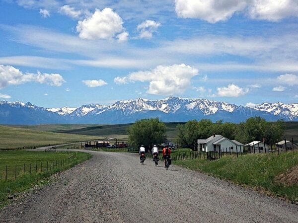
Day 1: Baker City to Halfway

GPX file

  1. Climb (1) at mile 24 is the Sparta Grade: – 4 mi @ 6%.
  2. Climb (2) at mile 46 is the Richland Grade: 4.5 m @ 8.7% of which 3 m @ 9%.
  3. Services and Water in Richland at mile 43.
  4. Highest Traffic: Hwy 86 near Baker City with a traffic volume (AADT) of 844 steadily decreases going east to 578 before the Richland Grade (source: ODOT TransGIS).
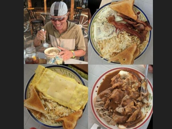
  • Breakfast at the Inland Cafe.
  • Pass by the Oregon Trail Memorial and Interpretive Center.
  • New Bridge – Sparta gravel section miles 24 to 42 or 18 miles of gravel. Gold is said to have been discovered in Sparta in 1872. The town flourished for a while but soon found itself running out of water. A 32-mile ditch was built that provided the much-needed water for mining operations. As soon as the ditch was completed, the gold supply started to run out. In 1915, all hard rock mining ceased. The Sparta store of 1878 still stands.
  • Camp at Halfway Motel & RV Park with showers and laundry.
  • Dinner at the Main Place in Halfway.
  • Halfway has minimal services.

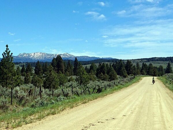
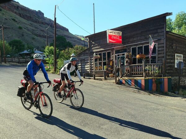
Day 2: Halfway to Imnaha

GPX file

  1. Climb – 17 m and 3 m or 20 m @ 3.5%.
  2. Water at mile 31 Brant Spring (black plastic hose) on the east side (on your right while climbing). Other water sources at USFS campgrounds along the way are labeled as unsafe.
  3. Road shoulders and the campsite are known to have goatheads.
  4. Highest Traffic: Hwy 86 heading east out of Halfway with a traffic volume (AADT) of 313 steadily decreasing going east to 119 on Wallowa Mountain Road Route 39. (source: ODOT TransGIS).
  • Breakfast at Wild Bill’s.
  • No services beyond Halfway.
  • Dinner at the Imnaha Store & Tavern which provides minimal services.
  • Stay at the Imnaha Canyon Lodging & R.V. (830.719.5141) Camping there is possible, but the only way to shower and access a toilet is via a room. The proprietor Heather is bike friendly and eager to help. Similarly, Cody, the proprietor of the Imnaha Tavern (830.719.5141) is bike friendly and has offered showers at minimal costs to dispersed campers. Call in advance.
  • Hells Canyon Overlook.
  • Imnaha River, a National Wild and Scenic River.
  • Eugene Pallette’s Ranch, a 1930s survivalist ranch.
  • College Creek Ranger Station, on the National Register of Historic Places.

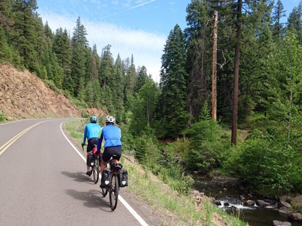
Day 3: Imnaha to Wallowa

GPX file

  1. Shoulders are known to have goatheads!
  2. Climb – 8.5 m @ 6.5% including a steeper pitch of 4.5 m @ 8%. Miles 3-8 contain rough and steep sections that are very remote with no cell service. This is the crux of the route. It is recommended one carries a personal locator beacon.
  3. Services at mile 34 in Enterprise.
  4. Highest Traffic: Hwy 82 heading west out of Enterprise with a traffic volume (AADT) of 2463 from mile 37-44. This is the busiest segment of the tour (source: ODOT TransGIS).
  • Breakfast at the Imnaha Tavern is possible but they open later. They can provide breakfast ‘togo’ options if you use the motel where microwaves are available.
  • Soon outside of Imnaha the route follows a Nez Perce Trail [see Adventure Route: Joseph, Oregon to Asotin, Washington], this journeys through the Zumwalt Prairie Preserve along a route indicated by this Zumwalt Prairie Tours Map, county roads 676 and 716. This 1965 article describes ‘Riding The Chief Joseph Trail’ (horses) over the same route. (contact: Jeff Fields 541.620.1250, Zumwalt Prairie Preserve).
  • Camp at Wallowa Valley Stay N Wash. It’s also a laundromat. They have a lawn that is shaded in the afternoon.
  • There is also a place to pitch a tent at the Lions Park between the RR Tracks and the Truck Route to the north, come as you go, shade, but no grass, water, or toilets. One could leverage the coin op showers at the Stay N Wash.
  • Wallowa has minimal services.
  • Dinner at the Wallowa Mountain Bar & Grill.

Day 4: Wallowa to Cove

GPX file

  1. Climbs (1) – The road out from Wallowa up Minam Grade is likely to be the busiest stretch with one steep and long climb, the Minam Grade, 4 m @ 5%.
  2. Climb (2) – 18 m @ 3% including a steeper pitch of 7% over 2.5 miles.
  3. No services from Wallowa to Cove.
  4. Highest Traffic: Hwy 82 heading west out of Wallowa after the Minam Grade with a traffic volume (AADT) of 1328. (source: ODOT TransGIS).
  • Breakfast at the Wallowa Mountain Bar & Grill.
  • Minam Wild and Scenic River.
  • Dinner at the Steakhouse At Cove.
  • Minimal services in Cove.
  • Camp at the Cove Swimming Pool fed by warm springs. The pool has been closed during the pandemic, but private parties can make reservations.

Day 5: Cove to Baker City

GPX file

  1. Climbs (1) and (2) – 3 m @ 5% and 5 m @ 3.5% with some steeper pitches.
  2. No services beyond Union at mile 9 until Baker City.
  3. Water and toilets at Catherine Creek State Park mile 17.
  4. Highest Traffic: Hwy 237 into Union with a traffic volume (AADT) of 632. (source: ODOT TransGIS).
  • Breakfast in Union at Gravy Dave’s.
  • There is a Union Market grocery store.
  • The Medical Springs Hwy is a section of a Cycle Oregon and Scenic Byways route with very low traffic density.
Notes & Options

Route Notes

  1. Hazards
    Goat’s Head (Tribulus Terrestris) on some shoulders.

Comments

Have you ridden this route? Got a question? Join the discussion!

Love Where You Ride! Learn More

On day 3 you pass through the Zumwalt Prairie Preserve, an area protected by The Nature Conservancy.

“The Conservancy manages the Zumwalt Prairie Preserve to support and advance conservation, while also providing high-quality and diverse habitat for native species on the Preserve. TNC aspires to achieve and sustain conservation values in the context of sustainable livestock grazing as the predominant economic land use across this privately-owned landscape. Further, TNC donates bull elk and buck deer LOP tags to local service organization raffles each year. To date, the tags have raised nearly $300,000 for Wallowa County charities.”

Nez Perce Homeland Center
Many of the lands you ride through were once the homelands of the Nez Percé, tribe.[Brittanica]

On day 3 / 4, of your stay in Wallowa, we encourage you to learn more about the Nez Perce by spending an hour or two at the Nez Perce Wallowa Homeland Visitor Center. The center is open by appointment only, e-mail info@wallowanezperce.org

Videos

The Ride! Wallowas Tour

A quick 2-minute video of what to expect on your ride!

Ridden and Reviewed by:

BenG

BenG / Team Dirty Freehub (Alum)

Ben was the first bike-packing guru at Dirty Freehub, publishing multi-day routes that he curated. He is also the creator and developer of the Bend Shorts series. (2018 – 2022)

Explore Similar Routes:

Geology

Sign Up for the Dirty Freehub Newsletter

info@DirtyFreehub.org
Terms of Service Privacy EEO Policy Our Values
Dirty Freehub is 501(c)3 non-profit organization.
©2025 Dirty Freehub :: All Rights Reserved :: Website Design
Cleantalk Pixel

We Need Your Support!

Dirty Freehub is a 501(c)3 nonprofit funded by generous donations from riders like you!

  • $25 Keeps the lights on (web hosting, technology tools, insurance, etc.)
  • $50 Keeps lights on + up to date route conditions
  • $100 Continued route development
  • $200 Fully documented route guide
  • $200+ Gravel Girl giggle of gratitude

Donate Today