Terrible Tilly
Permit required! See the Notes & Options tab for details.


Caution! We do not provide turn-by-turn directions in our GPX files. Those are auto-generated by your bike computer and are usually less than 70% accurate. Learn more.
For help loading a GPX file onto your bike computer, go here.
DownloadHighlights & Remarkable Spots
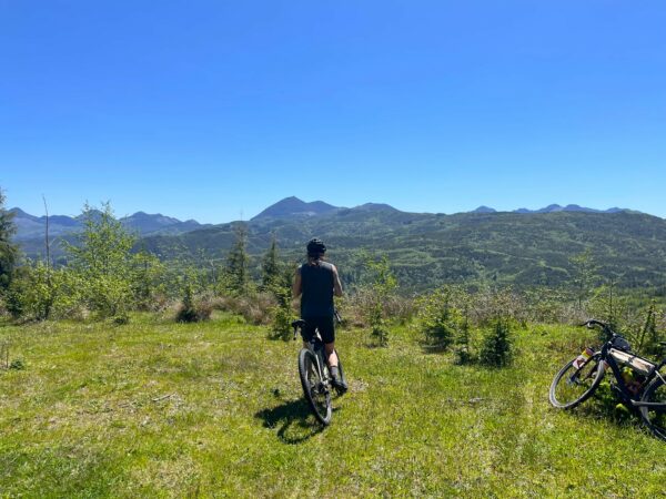
Ecola State Park / ~ Mile 1.5 to 6
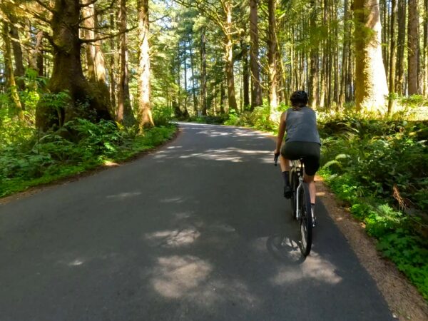
In 1806, Captain William Clark and 12 members of the Corps of Discovery traveled through the park in search of a beached whale near present-day Cannon Beach. After scaling the north slope of Tillamook Head and reaching one of its viewpoints, Clark described the vista as “… the grandest and most pleasing prospects which my eyes ever surveyed…” It was then that Clark and the other members of the expedition viewed burial canoes of the Kilamox (Tillamook) Indians. The present-day park falls within Tillamook’s ancestral lands and archaeological sites nearly 1,000 years old have been found.
Ecola Point Viewpoint / ~ mile 3
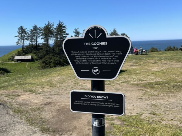
This will be your best view of Terrible Tilly (Tillamook Rock Light), 1.2 miles in the distance. The construction of the lighthouse was commissioned in 1878 by the United States Congress and took more than 500 days to complete. Tillamook Rock Light was officially lit on January 21, 1881. At the time, it was the most expensive lighthouse to be built on the West Coast. Due to the local erratic weather conditions and the dangerous commute for both keepers and suppliers, the lighthouse earned the nickname “Terrible Tilly” (or “Tillie”). Over the years, storms and the sea have damaged the structure, shattered the lens, and eroded the rock. The light was decommissioned in 1957, and has since been sold several times to private buyers. It remains privately owned today.
Indian Beach / ~ mile 4.5
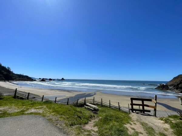
The sightseeing continues with another chance to stop and take in the beauty of the rugged and rocky Oregon coast and its beaches. Keep an eye out for surfers hoping to catch the next big wave, migrating gray whales, or bald eagles patrolling in the sky above.
The Tareen Filgas Foundation - Ecola Ridge Nature Sanctuary / ~ mile 6.5 to mile 8
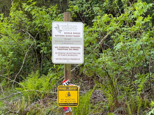
The Tareen Filgas Foundation’s mission is to protect birds and their habitat. Destruction of native habitat and the introduction of invasive plant species has resulted in decreased numbers of native birds, such as the endangered Snowy Plover (less than 2,000 breeding plovers remain in the Pacific coast population). In combination with the Audubon Society, the foundation has established and funded “Plover Patrol” for the North Coast to monitor Snowy Plover nesting sights and populations. Please respect the sensitivity of these natural areas and the mission of the foundation and stay on the designated route.
North Coast Viewpoint / ~ mile 10.5
Time for a change-up on viewpoint scenery! These views sweep to the east and south, showing off the undulations of the Oregon Coast Range.
The Oregon Coast Range is divided into three separate sections: North, Central, and South. Where you will be riding is part of the northern section. It is the younger of the three sections, formed during the Eocene age some 40 million years ago. Due to its geological makeup, it is hypothesized that some portions of the northern range were in fact islands during parts of the Eocene age. Can you imagine all of the land before you under an ocean save for those taller peaks?
Klootchy Creek County Park / ~ mile 13
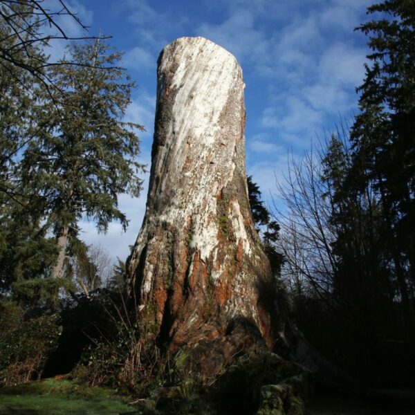
Folklore has it that “Klootchy” is the misspelled and mispronounced name of Antoine Cloutrie, a timber cruiser (a person who measurers forest stands for such things as average tree sizes, volume, and quality) from the late 1800’s. Klootchy is now the name of a creek that runs into the Necanicum River.
The park was once home to a giant Sitka spruce measuring 200 feet tall with a 17-foot diameter and a circumference of 56 feet. The spruce was officially the largest tree in Oregon and one of the largest trees of its species in the country before a windstorm finally destroyed it in 2007. Today, the park is now a gateway for the new Klootchy Creek mountain bike trail system.
Necanicum River Crossing / ~ mile 15.5
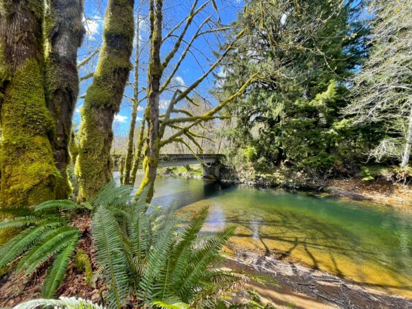
The Necanicum watershed supports the endangered coho salmon, coastal cutthroat and steelhead, as well as a handful of other fish species, such as sculpin, flounder and perch.
Unfortunately, “human activities such as timber harvesting, mining, water withdrawals, livestock grazing, road construction, stream channelization, diking of wetlands, and urbanization have damaged this critical habitat. As such, the coho numbers are quite small. Surveys from 1990 to 2000 indicate that only about 600 fish now use the river. Coho salmon prefer streams with a high degree of structural complexity, including the presence of large woods, flood plains, braided channels, beaver ponds, and occasionally lakes.” [Wikipedia]
Efforts to reestablish the native habitat are underway along some portions of the watershed. To learn more about these efforts, visit The North Coast Land Conservancy or the Necanicum Watershed Council.
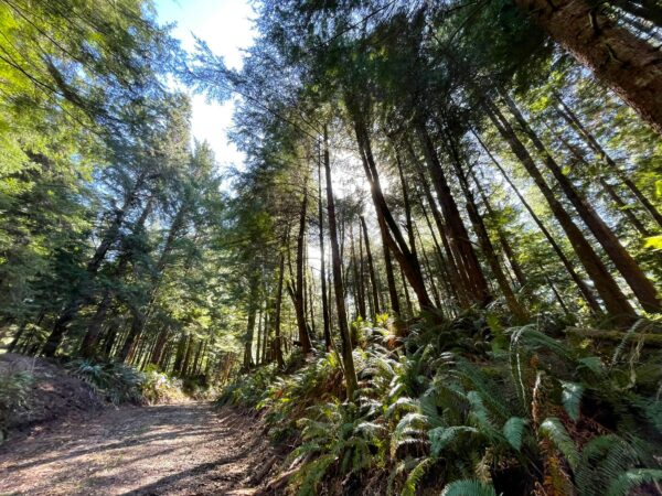
Harvested Timberlands / ~ miles 6 to 28
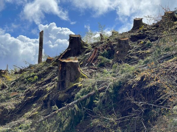
This section is privately owned and managed for its timber production by Lewis & Clark Timberlands/Nuveen Natural Capital. As of 2019, Lewis & Clark Timberlands own ~140,000 acres of Clatsop County forest and their property taxes contribute $1 million towards county services. Overall, the timber industry represents 1/3 of the economy in Clatsop County.
As this is active timberland, you will see clear cuts of varying ages along this route. To learn more about logging, including alternatives to clear-cutting visit Timberland Advisors or Ask a Forester.
Ecola Creek Forest Reserve / ~miles 28 to 29.5
You are now riding through the source of drinking water for Cannon Beach!
In 1999, the community of Cannon Beach purchased 120 acres of the Ecola Creek Watershed to protect the land, water, and wildlife habitat there. The property included three-quarters of a mile of Ecola Creek frontage within a diverse forest of spruce, alder, hemlock and cedar, including a remnant of old-growth rainforest where several western red cedars are estimated to be more than 350 years old. With further purchases, Ecola Creek Forest Reserve now totals 1,040 contiguous acres of forest.”
Credits & Acknowledgements
This ride guide is funded in part by the Oregon Coast Visitors Association.
This route is a variation of the Cannon to Klootchy route from the Our Mother the Mountain website. We appreciate their route finding efforts and great write-up!
When We Like to Ride This
Any day when the winds aren’t too high or the rain too heavy. Be aware that on sunny days, there are long, exposed sections and the heat/sun can get to you. Do NOT underestimate this. Pack plenty of water (or bring a filter to fill up your bottles from any of the numerous water sources) and stay on top of your sun protection.
Terrain & Riding
Roughly ~19 miles of this route is on Lewis & Clark Timberlands. The roads were built for logging and are still used to facilitate the logging of these lands. Therefore, you will come across roads that are in varying states of use/disuse. Some will be smooth dirt/gravel, others will have substantial bases of compact rock, some will be chewed up by the tracks of Caterpillars, and some will have been so long in disuse that they are now avenues of grass. Expect a mix of all of the above!
Every entry/exit point into Lewis & Clark Timberlands is gated and locked and is off-limits to any motorized vehicles. This means the only traffic you may encounter will be that of the loggers. It is actually quite lovely; in all the times I have ridden the timberland portion of this route, I have encountered only one logging vehicle. Note: if you do see any logging trucks, pull off the road and wait for them to pass. They can be driving fast and are not expecting to come across anyone on the roads.
The lack of human activity outside of the logging sites mean that you will most likely see elk. If you do see elk, remember that they are more sensitive to human disturbance than any other activity. Please keep space between yourself and any elk you see (~ 1000 yards or 0.2 miles). If they start to run, stop pedaling and let them escape in peace. Learn more about wildlife impact in this resource page we have put together.
The paved portions will have varying levels of car traffic (all depending on seasonality). In the Cannon Beach and Ecola State Park sections, be courteous and share the road. A smile and wave go a long way in keep relations amicable between bikes and cars. The sections on HWYs 101 and 26 involve high speed traffic. Keep alert.
At mile ~28.5, there is an open creek crossing in the Ecola Creek Nature Reserve. If you feel confident, you can ride your bike straight through it. However, if the water is running high or if you aren’t sure of your ability, it is always best to err on the side of caution, dismount, and walk your bike through it.
As noted in the introduction, this route rides more like a 50-miler due to the toughness of the terrain. The spider’s web nature of the logging roads adds to its complexity, even with GPS guiding your way. If you are ever uncertain of the route while riding it, stop, relax, and review the map while you let your GPS catch up to your location. On that note, a highly accurate GPS unit is recommended. While in the middle of the timberlands, I have compared my location on my Garmin head unit with that of the Ride with GPS app on my phone and the Ride with GPS map had me miles from my actual location.
E-bikes of any kind (pedal assist or throttle) are NOT allowed on Lewis & Clark Timberlands. We are fortunate that we have access to these lands for recreation and do not want to lose that privilege.
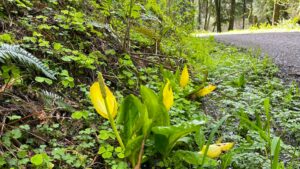 Lastly, be on the lookout for this flower, swamp lantern; they bring a burst of bright yellow to the forest floor while many other plants are still sleeping. They are also known by another name, one that you may be more familiar with, Skunk Cabbage. And it’s easy to smell how it got that name; it emits a foul odor to attract insects that are active early in the year to do its pollinating.
Swamp Lantern is abundant along the coast and is important to the diet of black bears waking from hibernation and for deer and elk. Look for it growing in wetlands, marshes, creek margins, and other areas of water seepage along this route.
The Start
There are multiple free public parking lots in Cannon Beach. One is at the start, just next to Sleepy Monk Coffee Roasters. Near the parking lots are also public restrooms and water fountains. You can use those to change and fill up your water bottles.
Alternative Parking Locations
- N Spruce Street lot between E 1st Ave and E 2nd Ave. Lat/Long: 45.897239, -123.960127
- E 2nd Ave lot at Corner of N Spruce Street and E 2nd Ave. Lat/Long: 45.898202, -123.959542
Food & Water
- None.
Route Notes
Permit required! A lot of this route in on private Lewis & Clark Timberlands managed by Nuveen Natural Capital. Public, non-motorized access is allowed, but you need a permit. The permit is free.
We recommend a red blinky light with a looking radar detector for the paved sectors of this route. Something like a Garmin Varia.
Bathrooms at Klootchy Creek County Park, ~ mile 13.
Love Where You Ride! Learn More
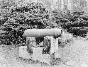 The ride starts and finishes in Cannon Beach. Named after a naval cannon that washed up after a shipwreck in the 1840’s, Cannon Beach has a ton of character. Haystack Rock is a massive towering rock formation off the coast, with adjacent stone “needles”, vibrant tidepools, and flocks of seabirds adorning the landmark. Nearby Ecola State Park is perched dramatically on the edge of a headland and offers panoramic coastal views, easy walking paths to scenic picnic areas, and extensive hiking trails.
Known as one of the Northwest’s top art towns, Cannon Beach is replete with art galleries, specialty shops, cafes, and fine dining restaurants. Visitors can watch glass blowers at work in their studio or attend year-round live theater performances. This creative edge can be seen in everything from the sensibility of the town’s residents to the annual sandcastle building competition that spotlights stunning works of art adorning the sandy beach.
Videos
Terrible Tilly
Explore the Tillamook Rock Lighthouse's captivating history and perilous allure in this fascinating video (14 minutes). Known as "Terrible Tilly," this abandoned beacon stands tall amidst the unforgiving Oregon coastline, braving treacherous storms and haunting tales. Discover why this iconic [...]
The Ride! Terrible Tilly
A quick 2+ minute video of what to expect on your ride along and near the Oregon Coast. Cannon Beach area.
Keep it Local! Learn More
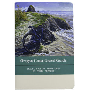
Related Guidebook
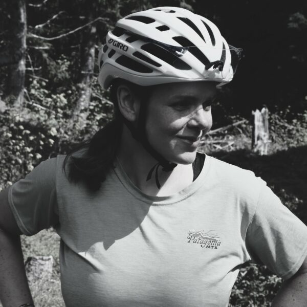
Ridden and Reviewed by:

 Behind every route is scouting, mapping, storytelling, and a whole lot of pedal power.
Have you ridden this route? Got a question? Join the discussion!