Rajneeshee


Caution! We do not provide turn-by-turn directions in our GPX files. Those are auto-generated by your bike computer and are usually less than 70% accurate. Learn more.
For help loading a GPX file onto your bike computer, go here.
DownloadHighlights & Remarkable Spots
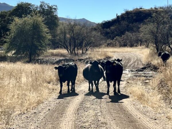
The Town of Antelope / Mile 0
Settled in the 1870s and incorporated as a town in 1901, Antelope was a railroad boom and bust town, before coalescing into a quiet ranching town of several dozen people for 80 years. That all changed in 1981 when the infamous Rajneeshee cult established a community compound of over 7,000 people at Big Muddy Ranch just a few miles from town, quickly establishing dominance over Antelope’s infrastructure and government and changing Antelope’s name to Rajneesh. Most longtime locals moved away. Criminal revelations in 1985 caused the cult to disband and leave the area. As of the 2021 census, the population of Antelope is back to a sleepy 38 people. [Oregon Encyclopedia]
The Dalles-Canyon City Wagon Road / Miles 0 to 29
The first 29 miles of this route follow a section of the 185-mile Dalles–Canyon City Wagon Road, a major freight and stage route built in the 1860s to link the Columbia River port of The Dalles with the booming gold mines of Canyon City (near present-day John Day) in eastern Oregon. Much of the road operated as a toll route, with different companies charging wagons, livestock, and stagecoaches for use. This wagon road later became part of The Dalles Military Road.
(Click to expand map, route in blue).
Former Site of Rajneeshpuram Compound / ~ Miles 18 to 20
When the Rajneesh cult evacuated Antelope in 1985, the town’s remaining 34 residents—longtime residents of Antelope—quickly voted to restore the town’s original name. Rajneeshpuram (the cult’s commune at Big Muddy Ranch) fell into disrepair and was eventually turned over to state ownership. Oregon sold the land to a Montana billionaire who then donated it to a Christian organization. The Washington Family Ranch Young Life Camp now occupies the property, which is private and not open to the public. Please respect their property and stay on the route. [Oregon Encyclopedia]
John Day River Viewpoint / ~ Mile 29
The John Day River is one of the longest free-flowing rivers in the continental United States, running more than 280 miles without a major dam. It drains a vast portion of north-central and eastern Oregon, carving deep canyons through layers of basalt, ash, and ancient seabeds that reveal millions of years of geologic history.
The river is nationally recognized for its wild steelhead and salmon habitat, supporting one of the largest remaining wild runs of summer steelhead in the Lower 48.
Ghost Town of Horse Heaven / ~ Mile 38
The ghost town of Horse Heaven once had a population of about 100 people and a 40-acre mercury mine. Thought to be named for herds of wild horses occupying the area, Horse Heaven’s mining activity spanned from the 1930s to the 1950s before being shuttered. Any remaining structures are situated on private property inaccessible to the public. Remediation work has been ongoing at the mine site to secure unprotected portals. It is advised not to go wandering off-route in this area and instead observe from the road. [Interstate Technology Regulatory Council]
Queen of Oregon Mine / ~ Mile 46
The Queen of Oregon mine is emblematic of the small mining ventures that dotted the high desert around Antelope and Ashwood — not large-scale operations like those found in other Oregon districts, but still historically significant as part of the region’s mineral exploration era.
Today, remnants such as collapsed adits, small pits, and minor tailings may still be visible on the landscape, offering a quiet but tangible glimpse into the speculative mining attempts of the late 19th and early 20th centuries.The Oregon Queen Mines were part of a small cluster of gold prospects worked in the Horse Heaven mining district during the late 19th century. Miners extracted gold from quartz veins in the surrounding basalt hills, leaving behind shallow shafts, adits, and tailings. Like many mining operations in this region, activity was intermittent and relatively small-scale, declining as ore quality and profitability diminished.
Historic Donnybrook Schoolhouse / ~ Mile 48
The Donnybrook Schoolhouse (circa 1914 to 1930) once served children from ranching families in this remote part of north-central Oregon. Like many one-room rural schoolhouses of the era, it functioned as both an educational center and a community gathering place, reflecting the self-reliant nature of early settlement in the high desert. The school closed as rural populations declined and students were consolidated into larger towns.
Credits & Acknowledgements
This route was independently discovered in the 2010s by Our Mother the Mountain and Dirty Freehub. Our Mother the Mountain provides a detailed description of the route on their website. It’s important to note that the version documented by Our Mother the Mountain differs slightly from the one presented here: it has a dogleg out to the John Day River, runs in the opposite direction and does not include updates for the newly paved sections.
When We Like to Ride This
Spring or Fall. There is no reliable water on the route so we feel it’s best to avoid the hottest months.
Terrain & Riding
What makes this route so cool is also what also makes it higher risk. Isn’t that always the way? Be prepared for high exposure to wind and sun. Sand pits and very rough roads are likely. You will be well-served by tubeless tires at least 40mm or wider. Goatheads (aka puncturevine) are prolific in the area, even on the roads. There is almost no cell signal along the entire route. Be prepared to handle mechanical, medical, and navigational issues with no support. We highly recommend an SOS tracking device like a Garmin InReach or a SPOT.
You’ll roll out of Antelope on pavement for the first 4 miles on the lollipop stick of the route. The Washington Family Ranch at around mile 20 is private property and not open to the public so their rights should be respected and their private roads avoided. This can be accomplished by simply staying on-route. After passing the ranch, the roads may be rutted and coarse with several stream crossings as you then roll through the abandoned mercury mining district of Horse Heaven at around mile 34 and reach the intersection of Gosner and Divide roads at around mile 44. This 24-mile section is the most demanding of the day.
Keep some gas in the tank for the next 12 miles of punchy rollers and probable headwinds. With four miles to go, you’ll be back on the paved lollipop stick heading into Antelope.
The Start
At the new Antelope Market and campground.
Food & Water
- None. We DO NOT recommend filtering water on this route or using spigots along the way. You should assume that the water is tainted from agricultural runoff and cattle.
Route Notes
This route has been impacted by the Cram Fire of 2025. It ignited on July 13, near Highway 97 east of Madras, and become the largest active wildfire in the United States, burning over 95,000 acres as of July 21. The fire destroyed dozens of homes and outbuildings. For the latest information see Central Oregon Fire and the Cram Fire Facebook page.
March 2024. This texture and demand of this route has changed significantly since 2023. Wasco County paved the sector into the Muddy Creek Ranch / Rajneeshee compound. Thus, this route is no longer as demanding as it once was. But … it is still a great ride!
Warning! You may encounter puncture vines (“goatheads”) on this route. These “buggers” can stick into—and even through—your tires, causing flats. They are most prevalent in late summer and early fall. The thorns are woody and extremely sturdy. Here’s our best advice:
- Use tubeless tires.
- Top off your tire sealant before the ride.
- Use a tire insert like CushCore.
- Carry extra sealant and a valve core removal tool so you can add more sealant if needed.
- Carry something like Dynaplugs for holes that don’t seal quickly.
Learn more on our goatheads resource page.
This is a back-loaded route. The second half is much more difficult than the first half. However, we recommend riding it in the direction as mapped, as the views are better and you get the fast paved descent into the old Rajneeshpuram compound. Climbing out of the compound, on the paved road, is long, tedious, and exposed.
Route Options
Shorter – do only the loop. Park alongside the road. 52 miles / 5800 feet of gain.
Videos
How the Rajneesh Cult Overran Antelope
What exactly happened when the Rajneesh cult took over Antelope, Oregon?
Podcasts
All About Basalt with the Rock Doctor
You will find these rocky columnar cliffs in Eastern and Central Oregon, but what exactly happened to form these unique structures? In this podcast, we talk with our resident rock doctor, Dr. Kim Ely.
Be Informed!
Keep it Local! Learn More

 Behind every route is scouting, mapping, storytelling, and a whole lot of pedal power.
Have you ridden this route? Got a question? Join the discussion!