Oxbow


Caution! We do not provide turn-by-turn directions in our GPX files. Those are auto-generated by your bike computer and are usually less than 70% accurate. Learn more.
For help loading a GPX file onto your bike computer, go here.
DownloadHighlights & Remarkable Spots
Oxbow / ~ Start/End
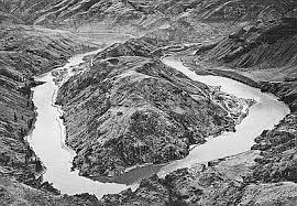
Oxbow, Oregon is the southern gateway to the Hells Canyon Recreation Area. It’s name reflects the U-shaped bend in the Snake River named after this agricultural implement.
The present-day community of Oxbow was established in the early 1960s during the construction of the Oxbow Dam by the Idaho Power Company. It is located near the former site of the infamous town of Copperfield (learn more below).
The Oxbow post office was established on May 1, 1965, after moving the office from Homestead six miles to the north.
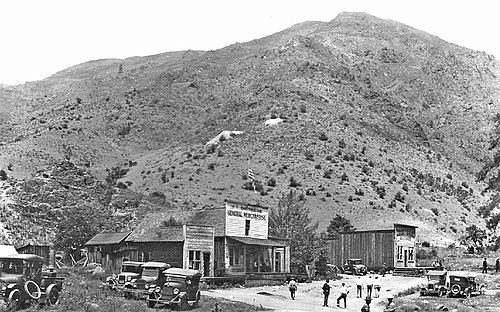
The Town of Copperfield / ~ Mile 0
Copperfield (present-day Oxbow), originally called “Copper Camp,” was established in the late 1890s along the west bank of the Snake River, downstream from a bend in the Snake River known as an oxbow.. Though the name suggests copper wealth, Oregon writer Stewart Holbrook claimed “there was no copper in Copperfield”; instead, the town existed to satisfy the “uninhibited appetites” of over two thousand workers engaged in nearby construction projects.
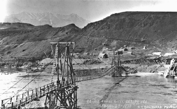
Law enforcement in Copperfield was minimal at best, despite having a town marshal and a four-cell jail on the second floor of the dance hall, which doubled as city hall. Saloons freely served liquor on Sundays, gambling ignored state prohibition laws, and organized brawls became common entertainment—particularly among rival groups of power-plant and railroad workers who clashed with a gentleman’s agreement to avoid knives and guns. The disorder prompted Oregon Governor Oswald West to impose martial law on January 2, 1914, sending his private secretary and five militiamen to restore order, in what became known as the “Copperfield Affair,” a scandal that drew national attention. [At left, Copperfield foot bridge across Snake River]
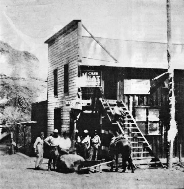
Despite a growing population and promise of prosperity, Copperfield’s future was short-lived. A devastating fire in 1915 destroyed most of the town, with a second blaze two years later leaving only the post office and schoolhouse. The post office closed in 1927, the railroad halted in 1931, and the school finally consolidated with Homestead in 1945. [At left, Copperfield Store]
Oxbow Fish Hatchery / ~ Mile 0
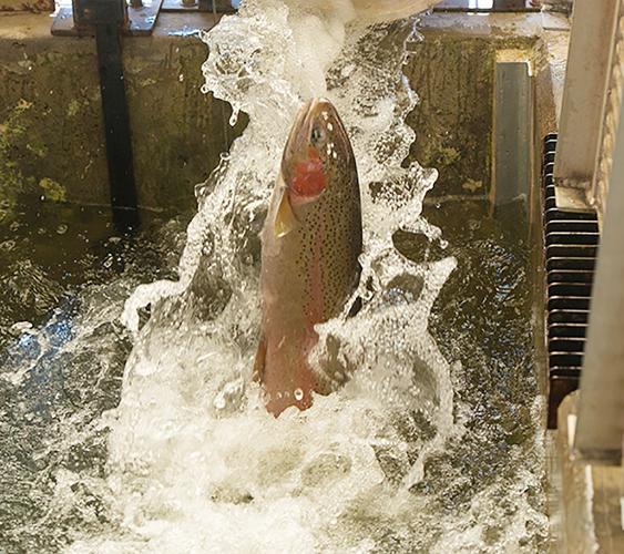
The hatchery was constructed in 1962 by Idaho Power Company as part of its operating license for Brownlee, Oxbow, and Hells Canyon dams on the Snake River. The Federal Energy Regulatory Commission requires Idaho Power to operate this facility to conserve fish runs that were impacted by the construction of the three dam complex. These dams were built without fish passage facilities with the idea that salmon and steelhead would be trapped and trucked around the dams. When this program failed, Idaho Power provided funds to build Oxbow Fish Hatchery. Idaho Power Co. is rebuilding the fish hatchery starting Spring of 2023. Work is expected to be completed the end of 2024.
Oxbow Dam and Power Station / ~ Mile 0
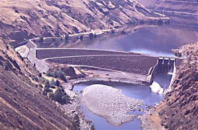
In the late 1950s, the Oxbow area experienced a revival when Idaho Power constructed three major dams on the Snake River: Brownlee Dam, Oxbow Dam, and Hells Canyon Dam. According to Idaho Power, “in a normal water year, the three plants provide approximately 70% of Idaho Power’s annual hydroelectric generation and approximately 30% of the total energy generated.” Unfortunately, the Hells Canyon Complex dams do not offer a passage for migrating salmon, resulting in the blockade of anadromous salmonids’ access to a section of the Snake River drainage basin extending from Hells Canyon Dam up to Shoshone Falls, known as the upper Snake River basin.
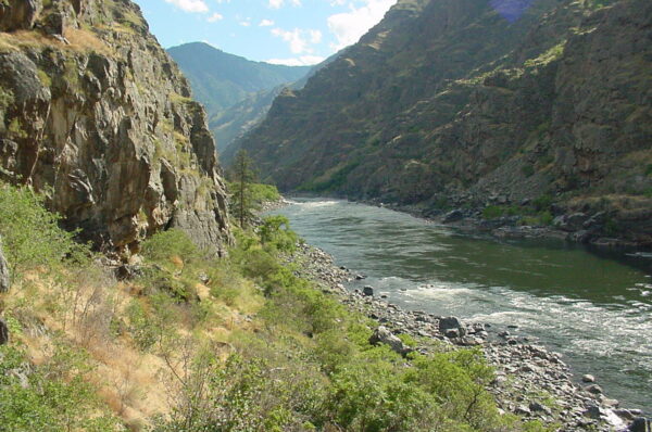
Snake River / ~ Miles 0-18
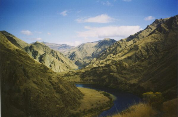
The Snake River originates in Wyoming and runs 1,078 miles to the Columbia. The Hells Canyon region of the Snake River are the ancestral lands of the Shoshone and Nez Perce tribes. According to the Nez Perce tribe, Coyote (a mythical figure in Indian folklore) created the Snake River Canyon in a single day to shield the people on the west side of the river from the Seven Devils, a group of malevolent spirits living in the mountain range to the east. In the late 1800s, the military forcibly removed the Native Americans, and settlers began ranching and mining in the canyon. Today, boaters can explore the area’s archaeological sites and historic homesteads, all of which contribute to the canyon’s colorful and fascinating history.
Northwestern Rail Company Tunnel / ~ Mile 1
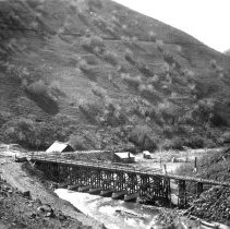
In 1906, the Northwestern Railroad Company was founded as a short-line railroad, laying tracks from Huntington, OR, along the Snake River. The preliminary work for this railroad spur included a 2,100-foot tunnel through the neck of the oxbow in the river. At the same time, the predecessor of Idaho Power Company began construction of the power plant that included a dam to divert water. In 1910 and 1911, the company was sold in two separate transactions to the OWR&N. It remains uncertain whether the 58-mile stretch of railway to Robinette, Brownlee, Copperfield, and Homestead was ever run independently or solely operated under the OWR&N.
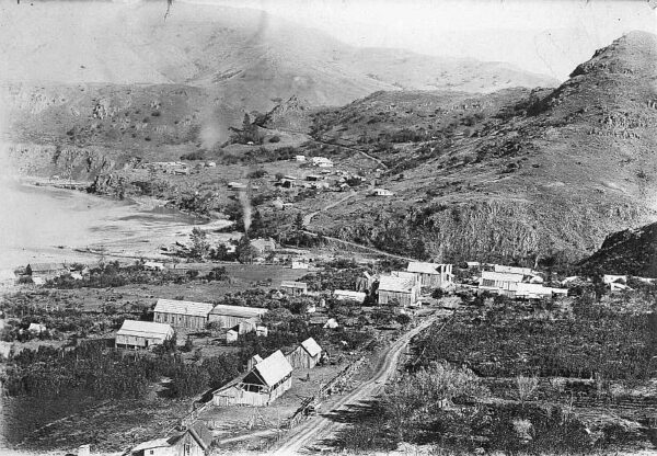
Homestead Ghost Town / ~ Mile 4
Homestead lies about 4 miles north of Oxbow. It was platted around 1898 along a Northwest Railway Company line that never developed. It thrived because of the patronage of the miners from the Iron Dyke Mine and because it was the railhead for local orchards. The community was named for the homestead claim of Frank E. Pearce. The Homestead post office operated until May 1, 1965 when it was relocated to Oxbow. Image circa 1915 – 1925.
Copper Creek Trail Head / ~ Mile 9
Copper Creek TH is a gateway into Hells Canyon Wilderness. Designated in 1975, Hells Canyon Wilderness is approximately 219,000 acres, and is a subset of the larger Hells Canyon National Recreation Area. This trailhead offers access to a rugged 8 mile out and back hike into the heart of the Oregon side of Hells Canyon Wilderness.
Credits & Acknowledgements
This ride guide is funded in part by grant from Travel Oregon.

When We Like to Ride This
Late spring, when the hills are green and the sun is bright but the temperatures are mild, or in mid-autumn when the leaves are changing color. At an elevation of 1,900 feet above sea level, it can also be ridden most of the winter, as long as the road to Oxbow is open!
Terrain & Riding
The Riding
Generally nice gravel, this old railroad turned road stays fairly level since it follows along the river. The river becomes your intimate companion, with the terrain playfully rising and falling for a total gain and loss of 210 feet. In fact, if you squint your eyes, you can almost pretend that you are floating along the Snake River.
The Terrain
Hells Canyon offers an awe-inspiring landscape that is a must-visit, must-see. The canyon itself, carved by the meandering Snake River, boasts the title of the deepest river gorge in North America at 7,993 feet (deeper than the Grand Canyon), with staggering walls that reveal eons of geological history.
The geologic history of the rocks of Hells Canyon begins 300 million years ago with an arc of volcanoes that emerged from the waters of the Pacific Ocean. Over million of years, the volcanoes subsided and limestone built up on the underwater platforms. The basins between them were filled with sedimentary rock. Between 130 and 17 million years ago, the ocean plate carrying the volcanoes collided with and became part of the North American continent. A period of volcanic activity followed, and much of the area was covered with floods of basalt lava, which smoothed the topography into a high plateau. The Snake River began carving Hells Canyon out of the plateau about 6 million years ago. Significant canyon-shaping events occurred as recently as 15,000 years ago during a massive outburst flood from Glacial Lake Bonneville in Utah.
The Start
Parking is available in the gravel Visitor Center lot. If you’re going to spend the night, Copperfield Park has water, showers, RV hookups and tent spots.
Route Notes
The gravel road ends at the Copper Creek Trailhead. There are restrooms and picnic tables for a nice mid-ride stop.
From here you can do a 3 to 3.5 mile out and back hike which follows along the Snake River. Learn more about this hike on All Trails. Note, we did not do the hike and in reading the description and reviews on All Trails, we believe some of the information has been generated by AI and has not been humanely sourced or verified. However, this YouTube video does give a good idea of what to expect.
If you do the hike, please leave a comment for us.
Route Options
Another route in the area, but much, much more demanding is the Hell of Hess ride. This is a great option if you have a split group – part of the group looking for a big, demanding ride, part of the group looking for something more relaxed.
Love Where You Ride! Learn More
 At 7,993 feet deep, Hells Canyon is North America’s deepest river gorge. The greater Hells Canyon region is the hub of three great eco-regions, from high alpine lakes in the surrounding mountains to the dry and rocky slopes along the Snake River. This diversity in bio-regions is integral for climate change resiliency for species as they adapt, and ultimately survive, the changing climate. As a migration corridor for a multitude of species, the greater Hells Canyon region allows them to migrate up and down in elevation, as well as up and down in latitude. To learn more about how you can get involved in protecting this rich environment, visit the Greater Hells Canyon Council’s website.
Videos
The Ride! Oxbow
A quick 2+ minute video of what to expect on your ride.
Greater Hells Canyon Region
This video highlights the importance of the Greater Hells Canyon Region for wildlife migration and climate resiliency. This special place is located in NE Oregon, right on the Idaho border.
Clipping Fins!
Wildlife technicians use various methods to clip adipose fins so that anglers can differentiate between wild and hatchery salmon. In this 2-minute video, learn what is an [...]
Keep it Local! Learn More
Related Guidebooks
-

All Access Gravel Guide Eastern Oregon (Collector’s Edition!)
$12.50Now shipping! A 64-page pocket-sized gravel guide. Featuring gravel routes, art, culture and local history. A one of a kind…Add to cart -

All Access Gravel Guide Western Oregon (Collector’s Edition!)
$12.50Now shipping! A 64-page pocket-sized gravel guide. Featuring gravel routes, art, culture and local history. A one of a kind…Add to cart

 Behind every route is scouting, mapping, storytelling, and a whole lot of pedal power.
Have you ridden this route? Got a question? Join the discussion!