Dirty Freehub
Favorites Sign In Search
  • Search
  • Donate
  • Gravel Routes
    • Explore by Region
    • Explore by Type
    • Explore by Collection
  • All Access®
  • Stories
    • Bike Life
    • Culture & History
      • Central Oregon
      • NE Oregon
      • Bend Trails
      • Death Valley
    • People & Places
    • Lands
      • Arizona
      • Central Oregon
      • NE Oregon
    • Love Where You Ride
  • Events
  • User Guide
    • Route Types
    • How We Rate Routes
    • Using the Map
    • Loading a GPX File
    • Glossary
    • FAQs
  • Inside DF
    • The Team
    • Our Missions
    • Impact Reports
    • Press
    • Sponsors
  • Store
    • Gravel Guides
    • Merch
  • Donate
  • Cart
  • Sign In
  • Favorites

Oregon Timber Trail (Gravel) / Sector 1 – Lakeview to Paisley

Development Route / Southern Tier, Oregon / Published: Apr 2025 / Directions
Save to Favorites Remove from Favorites
Abbot Road - Hood Tier Loop
*
Route:
Point to Point | 80 mi
*
Gain:
6,993 ft
*
Surface:
TBD
*
Technical Difficulty:
Unknown
*
Navigation:
Attention Required
*
Locale:
Remote
*
Tire Suggestion:
??
*
Options:
---

Winding through some of the most remote and rugged terrain in the state, the gravel version of the Oregon Timber Trail offers a wild and unforgettable journey deep into the heart of the Cascades. This is not your average gravel tour—it’s a backcountry odyssey that threads together forest roads, alpine lakes, volcanic landscapes, and charming mountain towns, all while tracing the backbone of Oregon from south to north.

What makes this route special isn’t just the sheer beauty—it’s the sense of adventure. You’ll ride beneath towering firs, past lava flows frozen in time, and alongside crystal-clear creeks where solitude reigns. The gravel version of the trail opens up a more rideable and accessible experience compared to the singletrack original, but it doesn’t sacrifice the spirit of exploration.

Whether you’re seeking a multi-day bikepacking trip or planning to ride it in sections, the Oregon Timber Trail (gravel edition) invites you to disconnect from the modern world and reconnect with wild Oregon—its landscapes, its stories, and the quiet joy of traveling by bike.

—

This is Dirty Freehub’s edition of the Oregon Timber Trail – Gravel. The original OTT was “designed with mountain biking in mind – about 60 percent is mountain biking trail.

We’ve taken on this iconic route in cooperation with the Oregon Timber Trail Alliance to provide a long-distance point-to-point ride that can be done as a Credit Card Tour, on a gravel bike. This version of the route emphasizes sustainability and positive community impact. It is designed to support the rural towns and businesses along the way. A secondary goal is to maintain the route as close to the original OTT as possible.

The Southern Tier from Lakeview to Oakridge is the most physically demanding sector of the route. There are few services for food, water or lodging making the days riding usually in excess of 70 miles. Beyond Oakridge, there are a number of stops along the way, where a long day can be broking up into two riding days.

If this guide helps you plan your ride, please consider making a contribution to Dirty Freehub—and tag it “Oregon Timber Trail.” Your support helps us develop and improve this route and route guide for future riders.

This route guide is currently published as “In Development“. We need to develop detailed and accurate information for this sector. We are still investigating miles 24 to 30 and 40 to 60.

If you do ride this, please give us feedback on what you find. You can do so in the Comments block. And … we would love to receive pictures!

Read More
Map
Brown = gravel / dirt road
Blue = single track
Red = paved road
Purple = paved bike path

Credits & Acknowledgements

OTT Logo

This route guide is being developed in cooperation with the Oregon Timber Trail Alliance.

Ride Details

When We Like to Ride This

Jan
Feb
Mar
Apr
May
Jun
Jul
Aug
Sep
Oct
Nov
Dec
Not Rideable
Possibly Rideable
Rideable

Late Spring thru fall. Much of this sector is above 5000 feet with high points of 7100 feet.

Terrain & Riding

Logistics / Paisley

Lodging
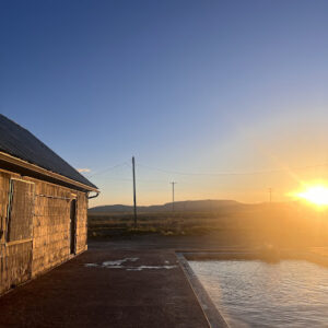
(1) Summer Lake Hot Springs.
This is located 6 miles up the highway, north of Paisley. The next day, you can continue north on the Highway another 5 miles and catch the Summer & Winter route and reconnect to the Oregon Timber Trail route (Sector 2).

(2) The Barn
This is located just east of downtown Paisley.

(3) Paisley Sage Rooms
Located in Paisley.

Food
Chewacan Station
Call to check hours and availability. Morning / Lunch

Pioneer Saloon
Call to check hours and availability. Lunch / Dinner

The Start

Lat / Long: 42.189204, -120.343415

TBD

Notes & Options

Route Notes

  1. Logistics. Where to stay at start (Lakeview). Where to stay at Paisley. See map links/references.

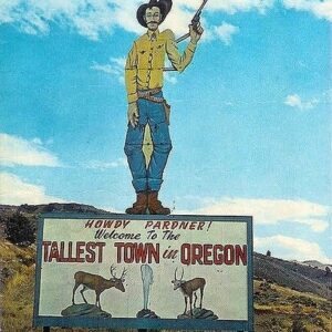
  2. Bike shop in Lakeview. Tall Town.

Route Options

Alt Start / Need to investigate.
Less distance option.Saves 22 miles. Ref: https://ridewithgps.com/routes/49993092?privacy_code=L3f0G0Q8sVGJRS8ZpTzKuqoH7ISBn1Jn

Comments

Have you ridden this route? Got a question? Join the discussion!

Help Make this Guide Better!

This route guide is a work in progress—and we need your help to make it great.

If you’ve ridden all or part of this route, your insights are invaluable. Let us know where you stayed (campgrounds, hotels, etc.), where you grabbed food (restaurants, convenience stores), and what challenges you faced on the trail. The more detail, the better.

We’re also looking for photos! Scenic shots, tricky sections, campsites—anything that brings this route to life.

And yes, we need your support. Maintaining and improving long-distance gravel routes like this one is increasingly falling on non-profit organizations like Dirty Freehub. Federal agencies can no longer keep up with the work required to maintain soft surface trails.

Leave your feedback in the comments below—and if you can, please consider donating. Together, we can keep this adventure rolling.

Love Where You Ride! Learn More

bullard canyon - sign squareLakeview was established in the 1860s. The area was initially populated by ranchers and homesteaders seeking fertile land in southern Oregon.

In 1900, a fire destroyed most of Lakeview’s business district, including over 50 businesses, the town hall, and two fraternal lodges. The fire was so intense that it was visible from Klamath Falls, 75 miles away. The town was rebuilt and by the early 1900s Lakeview had become a bustling small town with essential infrastructure, including schools, churches, a bank, and a newspaper, reflecting its growth as a regional center. Agriculture was the main economic driver for Lakeview and the surrounding region. The fertile soil, water from nearby lakes and streams, and ideal climate for grazing livestock made Lakeview a key hub for ranching and farming. It was also a supply center for some of the region’s gold mines.

Today, Lakeview has a population of approximately 2,500 residents. It is known for its close-knit community, outdoor recreation opportunities, and historical charm. At 4,798 feet above sea level, Lakeview also lays claim to being the tallest town in Oregon.

Keep it Local! Learn More

Hot springs at Neon Cowboy

Visit Lakeview

Just before kicking off your adventure down the Oregon Timber Trail get a great breakfast. Two of our favorite places are the Downtown Cafe and Bakery on E Street and Tall Town Cafe on N 4th street.

Looking for a great place to stay the night before? Check out the Neon Cowboy. Tell them (Sam) Dirty Freehub sent you.

And, if you need any last minute equipment or bike support, stop in at Tall Town Bike and Camp They. offer long term parking for riders also accept shipment of resupply boxes.

These shops are all locally owned and operated. They need and depend on your support.

Sign Up for the Dirty Freehub Newsletter

info@DirtyFreehub.org
Terms of Service Privacy EEO Policy Our Values
Dirty Freehub is 501(c)3 non-profit organization.
©2025 Dirty Freehub :: All Rights Reserved :: Website Design
Cleantalk Pixel

We Need Your Support!

Dirty Freehub is a 501(c)3 nonprofit funded by generous donations from riders like you!

  • $25 Keeps the lights on (web hosting, technology tools, insurance, etc.)
  • $50 Keeps lights on + up to date route conditions
  • $100 Continued route development
  • $200 Fully documented route guide
  • $200+ Gravel Girl giggle of gratitude

Donate Today