McKenzie Tough!


Caution! We do not provide turn-by-turn directions in our GPX files. Those are auto-generated by your bike computer and are usually less than 70% accurate. Learn more.
For help loading a GPX file onto your bike computer, go here.
DownloadHighlights & Remarkable Spots
SKYLIGHT CAVE / ~ MILE 7.5
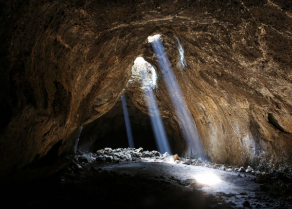
Open May through September, Skylight Cave can be entered by descending a short ladder. If conditions are just right, daylight beams down into the cave through ceiling openings, creating a visual spectacle begging to be photographed. The cave is an old lava tube – a geological structure that forms when outer layers of a lava flow cool and harden to form walls and the molten lava flowing inside eventually drains away. Skylight Cave is home to a sensitive bat population so following clean cave practices is critical. [Image by Jamie Hale/The Oregonian via OregonLive.com.]
Help us out: Is the cave actually along the route?
SANTIAM WAGON ROAD / ~ MILES 13 TO 16.5 and 17.5 TO 21.5
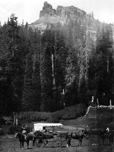
“The Santiam Wagon Road was built in the 1860s to connect the Willamette Valley, across the mid-Cascades and through Eastern Oregon, to the Idaho border … Unlike many historic wagon roads that were constructed for the purpose of traveling west, the Santiam Wagon Road was built to take travelers east. Central Oregon offered bunchgrass covered land, ideal for grazing the cattle that were beginning to overpopulate the Willamette Valley … The Santiam Wagon Road served as a livestock trail and the only freight route over this section of the Cascades for most of the 74 years (1865-1939) it was in use. It spanned a distance of almost 400 miles on today’s roads and provided passage for around 5000 wagons during the first 15 years of its existence.” The Santiam Wagon Road is listed on the National Register of Historic Places and you get to ride 7.5 miles on it today! [Image by Bowman Museum]
BIG LAKE AND HAYRICK BUTTE / ~ MILE 16.5
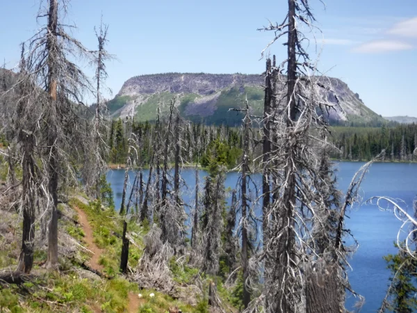
You’ll depart the Santiam Wagon Trail for about a mile to roll through the Big Lake Day Use Area and take in the views of not only Mt Washington but also Hayrick Butte, a somewhat rare type of formation called a tuya. A tuya is the result of a volcano erupting under a massive ice sheet and melting its way through to the very top where lava then pools at the ice surface. Check out the DF Connection podcast episode about Hayrick Butte. Big Lake was the first resting place for early westbound travelers on the Santiam Wagon Road. [Image by William L. Sullivan via StatesmanJournal.com]
CLEAR LAKE / ~ MILE 26
“With a maximum depth of 175 feet, [Clear Lake] is one of the clearest and coldest lakes in the Cascades … Brook trout and cutthroat trout reproduce naturally in the lake. Rainbow trout are stocked annually … The landscape, though, is very different from what it was 3,000 years ago. At that time, there was no lake here, only a densely forested drainage dissected by a rumbling white-water river. About 1,000 B.C., Sand Mountain erupted. Lava flowed out toward the McKenzie River and burned the forest as it moved. When the lava reached the river and struck the cold water, it stopped. The McKenzie quickly backed up behind the wall of lava, and Clear Lake was formed. The forest that had lined the river banks was submerged under 120 feet of water. Remnants of these trees still stand today, incredibly preserved in the depths of the near-freezing lake.” [U.S. Forest Service. Image by Linn County Parks & Recreation]
MCKENZIE RIVER / ~ MILES 27 TO 45
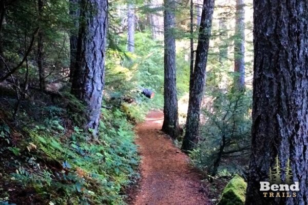
The 26-mile McKenzie River Trail is arguably one of the most beautiful singletrack trails in Oregon. The McKenzie was designated as a Wild and Scenic River in 1988 “for its outstandingly remarkable values of fish, scenic quality, recreation, hydrology/geology and water quality. The ‘Blue McKenzie’ is well-known for its exceptional water quality, resulting from low turbidity, absence of organic material and the high water quality of its tributaries. The excellent quality of its fish habitat supports a variety of fish species, including three native wild trout—rainbow, bull and cutthroat trout—as well as wild spring Chinook. Recent vulcanism, including three distinctive lava flows, has shaped the river into pools, dramatic waterfalls and cascading whitewater.” [National Wild and Scenic Rivers System. Image by Bend Trails.]
DEER CREEK HOT SPRINGS AND BELKNAP HOT SPRINGS / ~ MILES 40 AND 45
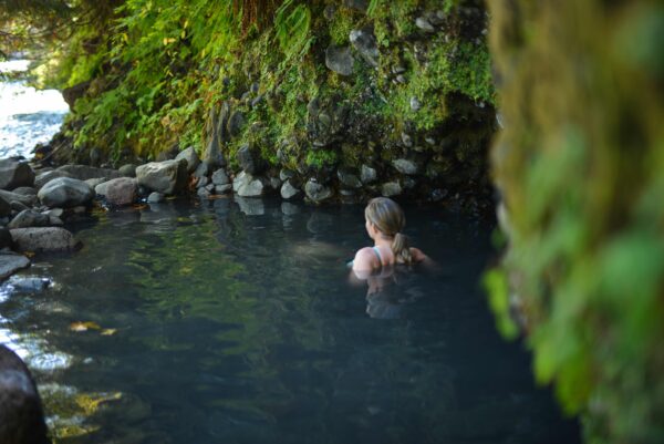
Aching back? Weary legs? Feeling chilled? You could make a pitstop for a soak at Deer Creek (aka Bigelow) Hot Springs (~ mile 40) or Belknap Hot Springs (~ mile 45). Deer Creek is free of charge, fits 2-3 people, and is warmest in summer and fall while McKenzie River levels are lower. Belknap Hot Springs is a resort surrounded by acres of landscaped gardens that charges a nominal hourly fee for soaking. Note carefully that clothing is *not* optional at Belknap so pack a swimsuit for soaking here. [Image by Eugene Cascades and Coast.]
Help us out: Are we accurate with this? Are there two hot springs?
OLD MCKENZIE HIGHWAY (OR-242) / ~ MILES 46 TO FINISH
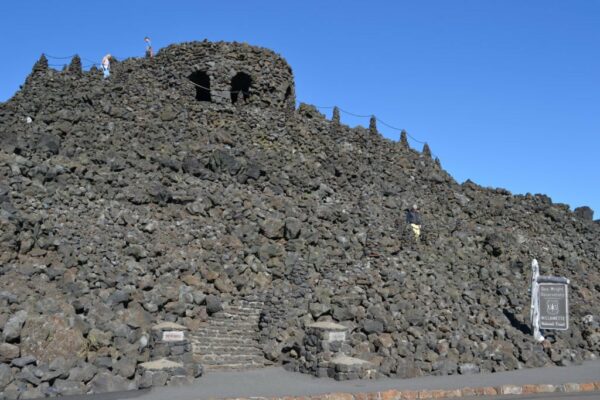
The western end of this 38-mile Oregon Scenic Bikeway climbs and winds through deep, dark, and damp old-growth forest before opening up to lava fields and stunning views near the top. At the summit, you can enjoy interpretive panels on history and geology as you climb the steps to Dee Wright Observatory to gain a panoramic view of Mt Washington and the Three Sisters Wilderness. The eastern slope winds through more lava fields before dropping down into high-desert ponderosa forests near Sisters. [U.S. Forest Service]
When We Like to Ride This
This route has a very limited riding window, and if you go the wrong time of year, the first sector can be an unrideable sandbox. Ideally, you want moisture in the ground!
There are two options. Middle spring / Early summer (~ May and June) when the snow has melted out at higher elevations, but the ground is holding moisture. It’s a special bonus if you can time it such that the Old McKenzie Highway is closed to cars. The risk with this option is winter tree fall.
We think the better option is fall, several days after a high elevation snow. You want the snow to melt out and the overnight temps to fall below freezing. Ride it in the morning before significant thaw occurs. October is the best chance for these condition.
It is tough to get these conditions described above, but when you do the route is very rideable and fast.
Also, we prefer the route mid-week to avoid peak moto and car traffic.
Check ODOT for the latest conditions. Also, here is a graph showing the historical opening and closing dates for the Old McKenzie Highway.
Terrain & Riding
Bring your chunky rubber: 50 mm tires are almost a must for this route. We prefer riding this counter-clockwise as we find it more “comfortable” to climb (rather than descend) the chuck on the Santiam Wagon Road. The views are also more dramatic and revealing in this direction.
The first 16 miles are gravel and provide stunning mountain views. You’ll want low air pressure here for sand, chunky dirt, and soft jeep/moto track stretches. Watch for fallen trees for a couple of miles after the gate at mile 21.5. At the end of a short and steep downhill, enjoy fast hard-packed gravel. Hop onto a bit of singletrack leading to Clear Lake, a great spot for a snack and adding some air back into your tires for the next segment.
From Clear Lake, you’ll climb up a short but steep paved access road, cross highway 126, and then ride parallel to the McKenzie River for 17 miles, alternating between gravel (this is the unknown part of this route) and the famed McKenzie River Trail. The trail here is rated mountain bike intermediate. Thus, part of the adventure!
Consider adding more air to your tires when you hit Highway 126 again because, in one mile, you’ll begin the 22-mile/3700-foot climb up the old McKenzie Highway OR-242. Watch for wildlife here in the deeply forested early miles of the climb. At the top, you’ll be rewarded with epic views and then a super fun, winding 10-mile/2,000-foot descent with a few rollers and flats mixed in. There is virtually no shoulder so exercise caution with regard to vehicles (if the highway is open), potholes, and possibly even icy patches.
The Start
Cold Springs Campground. There are 23 single campsites in this facility. Water is available by hand pump and there are three vault style toilets. Each site is equipped with a picnic table and fire ring.
Food & Water
- ~ mile 27: Clear Lake Resort. Open seasonally.
Route Notes
We recommend a red blinky light with rear looking radar detector like a Garmin Varia for the McKenzie Highway sector, miles 45 to 78.
Route Options
This can be split up into a 2 or 3 day ride. There is an option of stays at Clear Lake Resort (~ mile 25) and at Belknap (~ mile 43) Hot Springs.
Love Where You Ride! Learn More
![]() This ride takes you along 17 miles of one of Oregon’s most cherished natural gems: the McKenzie River. Its crystal blue water, unique geology, spectacular waterfalls, and diverse ecological surroundings are not just an outdoor enthusiast’s dreamy playground but also serve as critical habitat for fish and wildlife. The McKenzie is one of the last locations where certain species of threatened salmon and trout can be found. The McKenzie River Trust is a non-profit organization working to protect the McKenzie through conservation, restoration, and education.
This ride takes you along 17 miles of one of Oregon’s most cherished natural gems: the McKenzie River. Its crystal blue water, unique geology, spectacular waterfalls, and diverse ecological surroundings are not just an outdoor enthusiast’s dreamy playground but also serve as critical habitat for fish and wildlife. The McKenzie is one of the last locations where certain species of threatened salmon and trout can be found. The McKenzie River Trust is a non-profit organization working to protect the McKenzie through conservation, restoration, and education.
Videos
The Ride! McKenzie Tough #1
A quick 2-minute video of what to expect on your ride!
Clear Lake: The Underwater Forest
Videographer Matt Cook takes us on a tour of Clear Lake, including under the surface where skeleton trunks of a millennia-old forest stand preserved in its frigid waters.
Early Logging Along the McKenzie
What were life and logging like along the McKenzie River in western Oregon in generations past? This picture history includes photos from the late 1800s and early 1900s.
Podcasts
Hayrick Butte with the Rock Doctor
The rock doctor is in the house! Dr. Kim Ely discusses about the unique geological features of Hayrick Butte, a rare type of volcano located in the Willamette National Forest next to the Hoodoo ski area in Central Oregon.
Keep it Local! Learn More


 Behind every route is scouting, mapping, storytelling, and a whole lot of pedal power.
Have you ridden this route? Got a question? Join the discussion!