Dirty Freehub
Favorites Sign In Search
  • Search
  • Donate
  • Gravel Routes
    • Explore by Region
    • Explore by Type
    • Explore by Collection
  • All Access®
  • Stories
    • Bike Life
    • Culture & History
      • Central Oregon
      • NE Oregon
      • Bend Trails
      • Death Valley
    • People & Places
    • Lands
      • Arizona
      • Central Oregon
      • NE Oregon
    • Love Where You Ride
  • Events
  • User Guide
    • Route Types
    • How We Rate Routes
    • Using the Map
    • Loading a GPX File
    • Glossary
    • FAQs
  • Inside DF
    • The Team
    • Our Missions
    • Impact Reports
    • Press
    • Sponsors
  • Store
    • Gravel Guides
    • Merch
  • Donate
  • Cart
  • Sign In
  • Favorites

Lower Bridge

Development Route / Bend, Oregon / Published: Oct 2018 / Directions
Save to Favorites Remove from Favorites
Cyclists on Barr road, gravel, near Tumalo, Oregon.
The "pump and chunk" section.
*
Route:
Loop | 76 mi
*
Gain:
3,100 ft
*
Surface:
40 % gravel, 60% paved
*
Technical Difficulty:
Moderate
*
Navigation:
Straightforward
*
Locale:
Rural
*
Tire Suggestion:
38 mm+
*
Options:
---

This is a great mixed gravel ride that takes in many elements of other routes like Alpaca, Westside Tour and H2O.

Caution, this is a Development Route. It has not been fully vetted or ridden by the Dirty Freehub Team. Go prepared and expect a bit more adventure. Any feedback you have would be much appreciated. You can leave it below in the comments block.

Read More
Map
Brown = gravel / dirt road
Blue = single track
Red = paved road
Purple = paved bike path
GPX Download   Version 0.1

Highlights & Remarkable Spots

Rainshadow Organics / ~ Mile 35

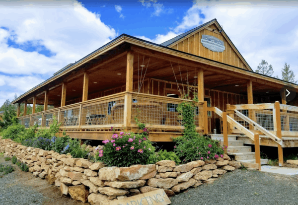
Around mile 35, you’ll pass Rainshadow Organics, an incredible locally owned farm, open seasonally (check their website for hours of operation!), where you can buy snacks and use their water spigots! Rainshadow uses sustainable practices and is deeply committed to solving the problems currently facing human health, regional food security, local economics and the environmental conservation of a shifting global climate.

Ride Details

When We Like to Ride This

A great late fall to early spring route.

Terrain & Riding

Without moisture, the “moon dust” on Barr road can be brutal. Also, Barr road has a 3 mile section of “pump and chunk”. Even though the route is 60% paved road, we recommend tires of 38 mm or better. Miles 56 to 59 (Barr road) are demanding with sand, big pump track like features, and some rocks.

The Start

Lat / Long: 44.058724, -121.357051

Northwest Crossing roundabout.

Food & Water

  • None.
Notes & Options

Route Notes

  1. Expect some traffic on the road sections. A red blinky light is recommended.

Comments

Have you ridden this route? Got a question? Join the discussion!

Help Make This Guide Better!

At Dirty Freehub, we believe the best routes are organic and driven by the riding community. This route and guide are a work in progress, and we need your help to make it great!

Provide us with route feedback, both good and bad.

  • Let us know about points of interest and viewpoints,
  • Submit pictures and videos,
  • Suggest a best time to ride,
  • Let us know about a better or alternative option,
  • And tell us about your favorite place to go after the ride for a burger and beer.

Submit your feedback via the comments block (tab just above the map).

Sign Up for the Dirty Freehub Newsletter

info@DirtyFreehub.org
Terms of Service Privacy EEO Policy Our Values
Dirty Freehub is 501(c)3 non-profit organization.
©2025 Dirty Freehub :: All Rights Reserved :: Website Design
Cleantalk Pixel

We Need Your Support!

Dirty Freehub is a 501(c)3 nonprofit funded by generous donations from riders like you!

  • $25 Keeps the lights on (web hosting, technology tools, insurance, etc.)
  • $50 Keeps lights on + up to date route conditions
  • $100 Continued route development
  • $200 Fully documented route guide
  • $200+ Gravel Girl giggle of gratitude

Donate Today