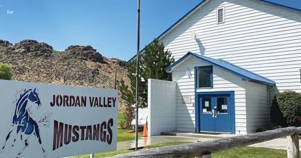
Jordan Valley Tour


Caution! We do not provide turn-by-turn directions in our GPX files. Those are auto-generated by your bike computer and are usually less than 70% accurate. Learn more.
For help loading a GPX file onto your bike computer, go here.
DownloadHighlights & Remarkable Spots
Jordan Valley / Start & End
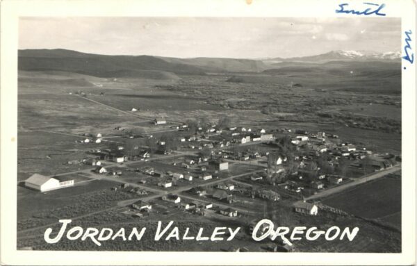
Jordan Valley was founded along the Skinner Toll Road. Among its earliest settlers was John Baxter, who established an inn, store, and post office in his cabin in 1867. The town served as a rest stop for miners journeying to nearby boomtowns like Silver City and DeLamar in present-day Idaho. Officially incorporated in 1911, Jordan Valley thrived while neighboring boomtowns dwindled after the mines faltered in 1875, thanks to its transition to cattle ranching. As of 2020, Jordan Valley has 179 residents.
Skinner Toll Road / ~ Miles 1-3
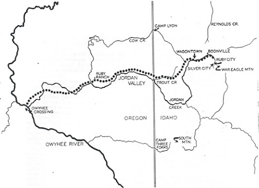
In 1865, Silas Skinner began constructing a toll road by hand, to aid in the transport of supplies for miners and the shipment of precious metals to the West Coast. The Toll Road opened on May 19, 1866, linking Silver City to Chico, California, and eventually to San Francisco, enabling freight to travel between Silver City and Chico in just a week.
During its peak, the Skinner Toll Road was one of the West’s most important routes, rich in legend and history. Stations lined the road, spaced ten to fifteen miles apart to serve travelers and their stock. While some were simple one-room shelters, others resembled fortresses set against the sprawling ranchland, each offering essential services and refuge in the rugged landscape. Here, weary travelers could find provisions and perhaps a discreet bottle of whiskey.
St. Bernard's Catholic Church / ~ Mile .5
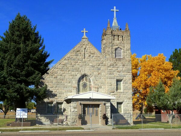
During its mining days in the late 1800’s, Jordan Valley did not have a church and only hosted visiting missionary priests from Boise and Baker. In 1914, Irish and Basque settlers began building St. Bernard’s Catholic Church from local stone. Oscillating between having an appointed priest and being a missionary church, St. Bernard’s has gone through a number of renovations, the most recent of which occurred in 2016.
Jordan Creek / ~ Miles 3 & 15
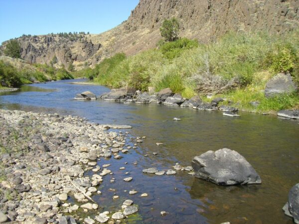
Jordan Creek is a 99 mile tributary to the Owyhee River. It generally flows west from near Silver City, Idaho, in the Owyhee Mountains to near Rome in the Oregon High Desert. See the Silver City ride guide.
It was in this creek that gold placers was first discovered in 1863, leading to the rush of growth in the area during the heyday of gold and silver mining. Today, Jordan Creek is used for irrigation by local ranches.
Pleasant Valley School House / ~ Mile 7
Education access in rural areas has needed an adventurous spirit over the last century. And in places like Jordan Valley, where ranching families live miles away from the nearest town, education is still a journey full of challenges. The Pleasant Valley Elementary School has been educating students since at least the early 1900’s, and continues to serve roughly 10 students grades kindergarten through 8th.
Reservoir Feeder Canal / ~ Mile 13
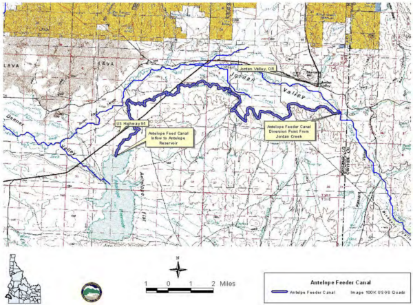
At mile 13, you’ll cross over what’s known as a feeder canal. Used for irrigation, these canals have been constructed to move water from one source to another within the system. This particular feeder canal moves water from Jordan Creek to Antelope Reservoir, nearly 15 miles away.
Pharmacy Hill / ~ Mile 17.5
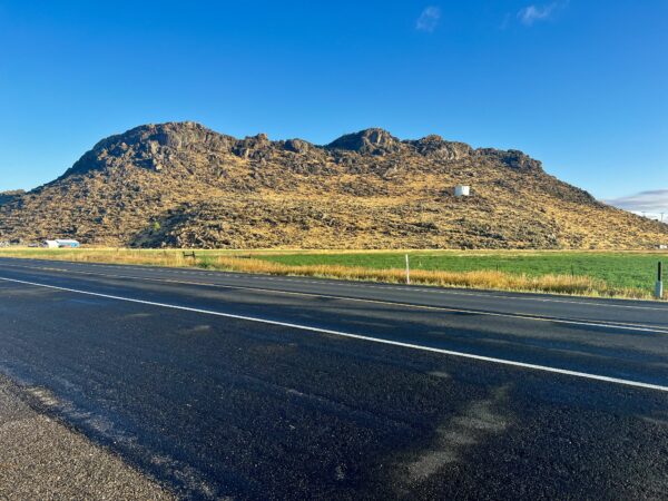
At this point, to your left is Jordan Valley’s most prominent geographical landmark,a blunt plateau called Pharmacy Hill. During the Great Depression, Dr. W.W. Jones, Jordan Valley’s community doctor, paid to have the rock face painted in bold white letters, advertising his office building. The word “Pharmacy” stood out and the hill remains known as Pharmacy Hill.
Pelota Court / ~ Mile 18
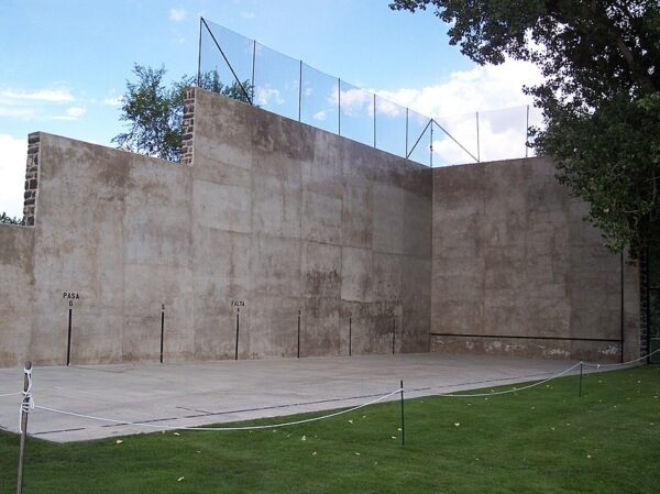
A pelota court, known as a fronton, is a handball court integral to Basque heritage, originating from the Pyrenees Mountains in northern Spain and southwestern France. Pelota, a traditional Basque handball game, was a key cultural practice that Basque immigrants brought to the U.S., particularly during the peak immigration period from the late 1880s to the mid-1920s. Basque settlers constructed this fronton in 1915 to celebrate and preserve their customs. Restored in 1997, this fronton is now Oregon’s last remaining Basque pelota court, serving as a cherished symbol of Basque cultural legacy.
Jordan Valley Cemetery / @ Finish
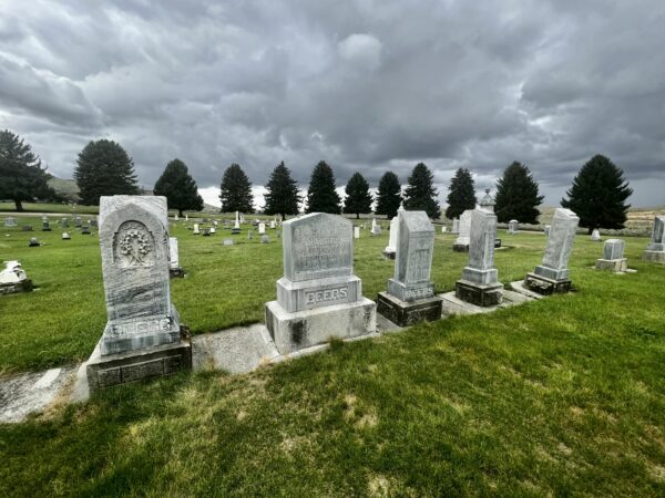
From the parking area, if you ride 0.1 miles north on the main road, on your left hand side will be Jordan Valley Cemetery. Here you will find gravesites from the late 1800s.
Credits & Acknowledgements
This ride guide is funded in part by Travel Oregon.

When We Like to Ride This
Located in Owyhee Country, also known as Oregon’s Canyonlands, this ride takes you through a high desert environment. Late spring into early summer will give you a touch of green and cooler weather, and early fall will give you a touch of orange in the trees and cooler weather. We do not recommend this ride in the middle of summer, as it can be very hot, nor in the middle of winter, as this area does receive snow and rain.
Terrain & Riding
Quiet paved roads and gravel that rides to the horizon await you on this enjoyable 18 mile loop out of Jordan Valley. Ride through rolling ranch land and wide open sage land with expansive views of Owyhee Country. You’ll cross over Jordan Creek two times, catch sweeping views of the surrounding mountains, pass by a small rural schoolhouse, and ride under ancient sage brush that is taller than you.
The Start
Jordan Valley City park has big shade trees and flush toilets.
Food & Water
- ~ Start & End / Jordan Valley. Sinclair Gas and Mrs. Z's Convenience Store both offer snacks and drink fill ups.
Route Notes
We recommend a red blinky light with rear looking radar detector like a (i.e. Garmin Varia). The gravel roads along this route have some traffic, and it can be difficult to hear traffic approaching from behind. A Varia type of device really helps.
At mile 15 you’ll cross the highway and take a gravel road around the bottom of Pharmacy Hill. This helps to avoid riding on the highway when it is still 55 mph; when you do get back on the highway, the speed has slowed down to 35 mph.
This ride takes you through rural farming country. Please give a listen to our podcasts on “Rural Riding Etiquette” before venturing out onto your ride.
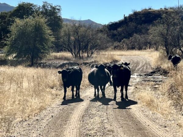
Open grazing and cows. Check out our resource page to learn how to pass by cows safely and without raising anxiety in the animals. Whooping and hollering is not the right thing to do.
A perfect weekend itinerary would be to combine this ride and the Silver City ride with the Jordan Valley Big Loop rodeo in May.
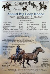
Big Loop Rodeo
Love Where You Ride! Learn More
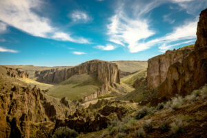 This ride explores the Jordan Valley and offers a glimpse of the vast Owyhee Uplands, 5+ million acres of high-elevation, expansive landscape with sweeping plateaus, sagebrush plains, mesas, and volcanic formations, stretching across parts of Oregon, Idaho, and Nevada. It’s home to unique wildlife like sage grouse, bighorn sheep, mule deer, pronghorn antelope, golden eagles, and raptors. You’ll also find rare and endemic plants, such as the Owyhee clover and distinctive high-desert wildflowers, which are exclusive to this region. Friends of the Owyhee works to protect this incredible area—learn how you can get involved by visiting their website. And, remember to “tread lightly” on your adventure.
Videos
Pelota (Basque Handball)
A 1-minute video showcasing the game of Pelota, Basque handball.
Basques in the West
This 1-hour video showcases the Basque people of Southern Idaho, Eastern Oregon, and Northern Nevada, highlighting their contributions to the culture and vitality of the West. It explores their role in the sheep industry and the central tension they encounter between preserving their traditions [...]
Podcasts
Tractors, Bulls and Lycra
In this podcast, we talk with Daarla K who is a rancher and farmer in northeast Oregon. She and her husband operate a 1000-acre farm that has been in his family since 1886. Learn how to safely pass by big tractors and combines, how to get through a cattle drive, and what aggressive behavior [...]
Be Informed!
Keep it Local! Learn More

Related Guidebooks
-

All Access Gravel Guide Eastern Oregon (Collector’s Edition!)
$12.50Now shipping! A 64-page pocket-sized gravel guide. Featuring gravel routes, art, culture and local history. A one of a kind…Add to cart -

All Access Gravel Guide Western Oregon (Collector’s Edition!)
$12.50Now shipping! A 64-page pocket-sized gravel guide. Featuring gravel routes, art, culture and local history. A one of a kind…Add to cart
Ridden and Reviewed by:


 Behind every route is scouting, mapping, storytelling, and a whole lot of pedal power.
Have you ridden this route? Got a question? Join the discussion!