Fields of Ballston
")
-2")
")
")

")
")
")
")
")
")
")
")
")
")
")
")
")
")
")
-2")
Caution! We do not provide turn-by-turn directions in our GPX files. Those are auto-generated by your bike computer and are usually less than 70% accurate. Learn more.
For help loading a GPX file onto your bike computer, go here.
DownloadHighlights & Remarkable Spots
Ballston School / Start and Finish
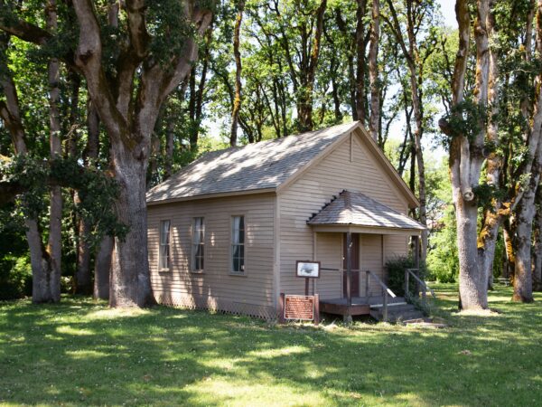
Built in 1855, the Ballston School house was originally constructed 1/2 mile southwest of Ballston with lumber from Elias Buell’s mill on Mill Creek; bricks from the local area, and square nails. Pulled by Oxen on log rollers, it was moved to its present site in 1874. Used as the only school until 1866, it stood alone until narrow gauge railroad and a station came in 1878. The school was donated to Polk County in 1862 by J.J Sechrist. [Ref: On-site kiosk]
The Ballston School is thought to be the oldest school building still standing in Polk County and perhaps in the entire state.
The Brigittine Monks / ~ Mile 5
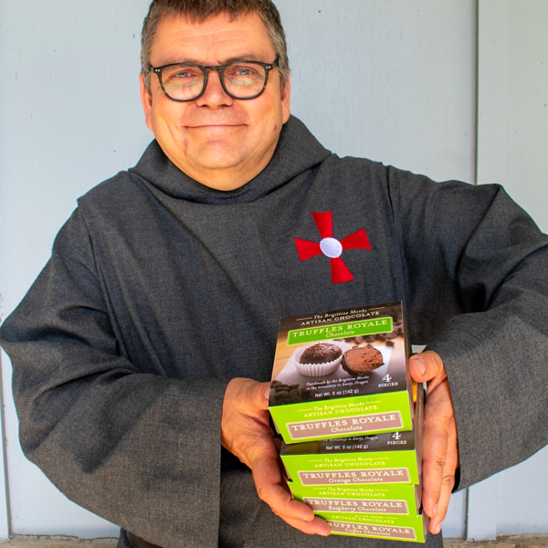
The Brigittine Monks follow a contemplative and structured monastic lifestyle centered on prayer, work, and community. Their daily routine is rooted in spiritual devotion, periods of silence, and reflection. Living together in a close-knit brotherhood, they share meals, worship, and responsibilities.
To sustain themselves, the monks have embraced artisan chocolate-making, crafting renowned truffles and fudge using traditional recipes and high-quality ingredients.
“The life of the cloister is austere, self-renouncing, the more austere, the happier they who dwell there. Love delights in sacrifice and immolation to the one loved, so the more complete the renunciation, the better.”
Irrigation / ~ mile 7
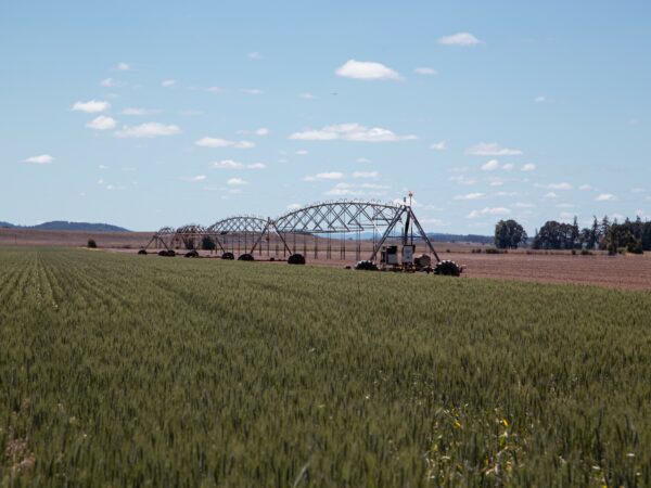
There are many types of irrigation that Oregon farmers use to water their fields: drip, flood, gated pipe, handlines, wheel lines, pivots, big and little guns, and linear moves. In the wheat field pictured here is a linear move.
As the name implies, linears move in a straight line across fields and can go forward or backward. Their design and mobility allows farmers to maximize the irrigated coverage of their fields. An electric motor drives synchronized wheels so the entire system moves as one across the field. A GPS system ensures that movement is accurate. Assuming everything is working correctly, this reduces a farmers labor when it comes to irrigating hundreds or thousand of acres of crops.
Grass Fields / ~ miles 7 to 18

Oregon is known as the grass seed capital of the world. Statewide, as much as 500,000 acres of land are used to grow grass seed. Polk county, through which this ride ambles, is one of the top producing counties of grass seed. Thanks to its climate, Oregon is one of the few places in the world where farmers are able to harvest grass seed directly out of the field and place it straight into storage. You will ride past thousands of acres of grass fields on this route and now you know it is one of the drivers of the agricultural economy.
Osprey Nest / undisclosed

Almost lost to extinction due to DDT use and habitat depletion, it is a wonderful sight to see multiple Osprey nests along this route.
Oregon’s state raptor is a migratory bird, calling Oregon home during their breeding and nesting season. These birds like nest sites that are as tall or taller than surrounding features, often resulting in the selection of utility poles for their nests. To accommodate this habitat need, utility companies have started building nesting platforms to give the Osprey a safe place to rear their young.
Ospreys are more tolerant of human activity than many other birds of prey, but they are sensitive to cyclists. Please avoid stopping or lingering near their nest sites, as this can cause unnecessary stress to both the parents and their young. Instead, admire these magnificent birds as you cycle by.
Grain Bins / ~ mile 14
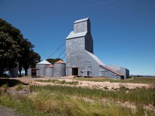
What is seed crop country without a cluster of grain bins?
The round structures with conical roofs are grain bins (not to be confused with silos!). Made of corrugated metal with ventilation, they are used to dry and store grains like wheat, oats, corn, and soybean serving as both domestic and export supply for feed, food, and fuel.
Silos are cylindrical but are commonly made of concrete, bricks, metal, and sometimes even wood. Their tops are usually dome-shaped, and they tend to be narrower and taller than grain bins. Silos traditionally store silage, which is grass or other fodder harvested green and wet, primarily to feed dairy cattle.
Wheat Fields / ~ miles 7 to 18
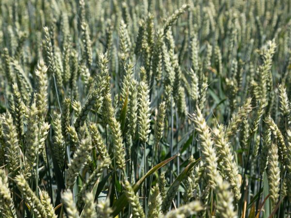
Wheat. Everyone knows what that is, right? But did you know that there are many varieties of wheat? In fact, there are thousands of varieties of wheat, but all wheat falls into six recognized categories: hard red winter, hard red spring, soft red winter, durum, hard white, and soft white. Wheat can also be bearded or beardless.
Wheat is Oregon’s biggest export, with 85% of it shipped overseas.
Clover Fields / ~ miles 7 to 18
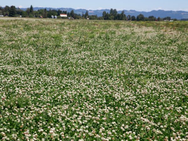
Over 40,000 acres of clover are grown in Oregon, with the Willamette Valley proving itself as the premier region for growing high quality seed. The four main varieties grown are white, red, crimson, and arrow leaf. Oregon farmers produce 85% of the crimson clover seed in the United Sates and 75% of the red clover seed.
Credits & Acknowledgements
This ride guide is funded in part by a grant from Travel Oregon.
When We Like to Ride This
This route should be rideable the majority of the year, even in the rain, but it is truly spectacular on a sunny day when the sky is bright blue and the fields are full of crops.
Terrain & Riding
Built with accessibility in mind, this route has limited hills and technical terrain. With an almost 50/50 mix of pavement and gravel with low traffic roads, you will hopefully find the ride enjoyable and not too challenging whether you are new to gravel riding, returning to fitness, biking as a family, or using an adaptive bike. When this route was ridden for review, the gravel roads were in great condition and easy riding. However, if a new layer of gravel has been recently laid, it could increase the difficulty.
The Start
Ballston County Park. If coming from Portland, this is the recommend this start.
Alternate Start / Perrydale
Lat/Long: 45.041890, -123.258521
You should be able to find parking at or near the Perrydale School.
Route Notes
Please ride with respect! Portions of this ride are through rural working ranch and farming country. Please give way to trucks, tractors, and combines. That may mean stopping as a group and letting a large combine pass, or it may be as simple as riding in a tight single-file line when an oncoming truck with trailing is approaching. To help alert you to traffic from behind, we recommend a rear-looking radar detector like a Garmin Varia. Also, give a listen to our podcast with a local rancher who talks about the challenges cyclists create for them and how we can be better visitors.
Route Options
If you’re ready for a slightly longer ride (22 miles) with nearly twice the elevation gain, considerThe Fields of Ballston – Long Edition. This route also starts and ends at Ballston County Park but includes two significant hills, adding an extra 400 feet of elevation gain and a short woodland section. This ride still meets our All Access criteria.
Podcasts
Tractors, Bulls and Lycra
In this podcast, we talk with Daarla K who is a rancher and farmer in northeast Oregon. She and her husband operate a 1000-acre farm that has been in his family since 1886. Learn how to safely pass by big tractors and combines, how to get through a cattle drive, and what aggressive behavior [...]
Keep it Local! Learn More

Related Guidebooks
-

All Access Gravel Guide Eastern Oregon (Collector’s Edition!)
$12.50Now shipping! A 64-page pocket-sized gravel guide. Featuring gravel routes, art, culture and local history. A one of a kind…Add to cart -

All Access Gravel Guide Western Oregon (Collector’s Edition!)
$12.50Now shipping! A 64-page pocket-sized gravel guide. Featuring gravel routes, art, culture and local history. A one of a kind…Add to cart
Ridden and Reviewed by:

 Behind every route is scouting, mapping, storytelling, and a whole lot of pedal power.
Have you ridden this route? Got a question? Join the discussion!