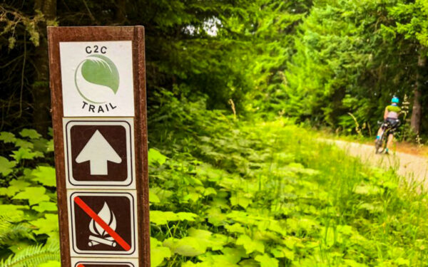
C2C (Corvallis to Coast) Trail
Permits Required: Both a Starker Forest permit and an Emery/Wilder permit are needed for this route. See the Notes & Options tab for instructions on how to obtain them.
The Sugar Bowl Trail + Mary’s Peak Road Sector is only open to bikes from May 15 to October 15. See the Notes & Options tab for details.


Caution! We do not provide turn-by-turn directions in our GPX files. Those are auto-generated by your bike computer and are usually less than 70% accurate. Learn more.
For help loading a GPX file onto your bike computer, go here.
DownloadHighlights & Remarkable Spots
The below Points of Interest are currently in development. What’s shown here are our rough ideas and working drafts.
Philomath
{To do: History of Philomath}
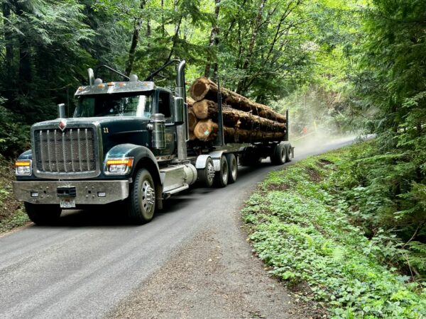
Starker Forest
Starker Forests began in 1936 when Oregon State forestry professor T.J. Starker bought cut-over and tax-delinquent lands during the Great Depression. Instead of letting them sit idle, he replanted Douglas-fir and pioneered a model of sustainable forestry that turned “worthless” land into thriving timber stands.
The company has remained in the family for four generations, each shaping the forests and strengthening ties with Oregon State University’s College of Forestry. From T.J.’s experiments in replanting, to Bond Starker’s push for professional forestry practices, to today’s operations, the family has managed over 90,000 acres of forestland in western Oregon. Their approach highlights both the economic and ecological role of private timberlands in the Coast Range.
Kiosk Signs
{To do. 6 along route. Get information.}
Mary's Peak
{To do. Some concept ideas:
Highest in the Range: At 4,097 ft, Marys Peak is the tallest point in Oregon’s Coast Range and a commanding landmark visible from Corvallis and Philomath.
Island in the Sky: Known for its unique blend of ecosystems—from noble fir forests to alpine meadows and “rock garden” areas—it’s been designated a Scenic Botanical Special Interest Area due to its diverse plant communities and wildflower-rich terrain. Ref: https://www.npsoregon.org/kalmiopsis/kalmiopsis19/4maryspeak.pdf
Download into ChatGPT.
Cultural & Geological Legacy: For the Indigenous Kalapuya people, Marys Peak—known as chatímanwi, or “place of spiritual power”—holds deep spiritual significance. Geologically, its rugged summit is capped by erosion-resistant gabbro, making it stand out for millions of years.}
Credits & Acknowledgements
Pictures courtesy of Travel Oregon and Cycle Oregon.
When We Like to Ride This
The Corvallis-to-the-Sea (C2C) Trail is best enjoyed in spring through early summer (May–June), when conditions are at their peak.
- Spring to Early Summer (May–June): Wildflowers, especially Oregon iris, blanket the Coast Range foothills. Snowmelt and spring rains keep water sources dependable, while mild temperatures and firm trail surfaces make for ideal riding.
- Summer (July–August): Riders are rewarded with ripe huckleberries and salmonberries along the route. However, the drier months can mean scarce water and hotter conditions, especially in exposed sections.
- Fall: Cooler weather and vibrant scenery create a comfortable ride, but it overlaps with hunting season in the Coast Range, so extra awareness is needed.
We do not recommend riding the trail in late fall or winter. The route is often very wet during these seasons, and riding can cause significant damage to the trail.
Terrain & Riding
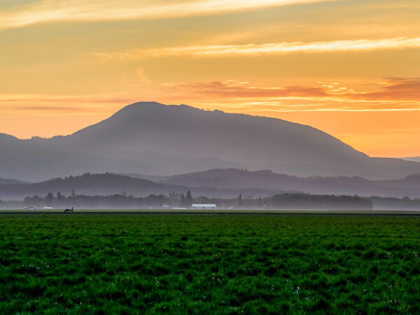
The Corvallis-to-the-Sea Trail offers a diverse riding experience as it winds from the Willamette Valley to the Pacific Coast.
- Corvallis to Philomath: The route begins near the confluence of the Willamette and Marys rivers on the edge of downtown Corvallis. A paved bike path leads out of town, weaving past quiet creeks, young forests, and suburban neighborhoods before reaching the smaller community of Philomath.
- Into the Coast Range: From Philomath, the trail climbs into the Oregon Coast Range. Riders follow rural paved roads past historic farmsteads before transitioning onto gravel forest roads. Expect a mix of logged landscapes and deep cedar and Douglas fir stands as the route skirts the northern slopes of Marys Peak—the tallest mountain in the Coast Range. In spring, wildflowers brighten the foothills, with Oregon iris adding purple and blue highlights. This section passes through the traditional homelands of the Kalapuya people.
- Descent to the Coast: The final leg drops toward the Pacific, tracing old Forest Service roads and remote logging corridors. Moss-draped forests of hemlock and cedar give way to the dramatic coastline and the coastal community of Newport, where the trail meets the sea.
If you time it just right, you may be able to stain your fingers with berry juice from huckleberries, blackberries, salmonberries, or thimbleberries.
The Start
Parking is allowed in the south gravel parking lot (at the corner of 53rd Street and Reservoir Road). Be sure to place a visible note on your dashboard stating that you are hiking or biking the C2C Trail and include your return date—or alternatively, call the Benton County Sheriff’s non-emergency line (541-766-6858) to notify them and avoid citation for an abandoned vehicle.
If you’d rather park inside the fenced, paved fairgrounds, there’s an alternative option—advance arrangements can be made with fairgrounds staff to park there for $10/night.
Food & Water
- ~ mile 33 / Big Elk Campground
Route Notes
Permits Required
Starker Forest | ~ Miles 11 to 15
The sector along Old Peak Road crosses through private property owned by Starker Forests. They are supportive of recreation on their land, but do require a (free) permit. Stop on by their office in Corvallis, or call 541-929-2477 to obtain an access permit. Note that e-bikes are not allowed on Starker Forest land.Emery Investments/Wilder | ~ Mile
Emery Investments owns the land from the gate near Oregon Coast Community College extending about 3.2 miles south along Road 200, which includes the Wilder Mountain Bike Trails. To access this area, visitors must obtain a free permit. Permits are issued by email after you send a photo of your driver’s license to permits@eenw.com.Once in Newport, check out one of the six bike rides by the City of Newport. They look intriguing!
Route Options
This route offers flexibility for different riding styles and trip goals. You can complete it as a multi-day out-and-back or as a one-way, point-to-point adventure using public transportation to return.
Credit Card Tour
If you prefer to travel light, this route works perfectly as a credit-card tour. Ride from Corvallis to Newport and reward yourself with an overnight stay in a lively coastal town. You’ll find plentiful lodging, dining, and hospitality options to round out the trip.
Bikepacking Option
For those seeking a classic bikepacking experience, this route can be stretched into a two-day journey from Corvallis to the coast:
- Day 1: Ride to Big Elk Campground (mile 33) for your first overnight stay.
- Day 2: Continue to the coast, finishing at South Beach State Park (camping), located just south of Newport. From there, it’s only three miles into Newport, where you’ll find a range of food and lodging options.
Point-to-Point with Public Transportation
If you prefer a one-way ride, you can finish in Newport and return by bus. The Northwest Connector offers scheduled service from Newport to Philomath or Corvallis. Bikes are allowed on the front rack on a first-come, first-served basis.
Out-and-Back Adventure
Looking for more miles? Turn this into a multi-day out-and-back by riding from Corvallis to the coast, staying overnight, and returning along the same route. Or, if you’re feeling creative, choose a different route home—and let us know what you discover!
Sugar Bowl Trail + Mary’s Peak Road Sector
From May 15 to October 15, riders can take the Sugar Bowl Creek Trail accessed at ~ mile 20.5. This 3-mile singletrack section is open to bikes only during this period (only) and connects directly to Marys Peak Road. This is our preferred ride of the C2C Trail.
- Route Map: C2C Trail (via Sugar Bowl & Mary’s Peak Road v0.1)
- GPX File: Download (v0.1)
Videos
The Ride! C2C
A quick 2+ minute video of what to expect on your ride.
Riding the C2C Trail: 60 Miles of Oregon Adventure
Dave Jones of Destination Oregon gives us a quick 5-minute highlight of the C2C trail. Imagine pedaling from Corvallis all the way to the Oregon Coast—60 miles of ever-changing scenery, from city parks to rainforests, quiet small towns, and rugged forest service roads. The trail is the [...]
Podcasts
Log Trucks: General Logging Operations
In this episode, the Dirty Freehub team goes on a tour to Alder Creek Tree farm with Jennifer Beathe, Forester and Outreach Manager of Starker Forests. During the ride to Alder Creek Tree farm in Corvallis, Oregon, we dive into identifying the recreational and rider safety around logging [...]
Be Informed!
Keep it Local! Learn More


 Behind every route is scouting, mapping, storytelling, and a whole lot of pedal power.
Have you ridden this route? Got a question? Join the discussion!