Bullard Canyon


Caution! We do not provide turn-by-turn directions in our GPX files. Those are auto-generated by your bike computer and are usually less than 70% accurate. Learn more.
For help loading a GPX file onto your bike computer, go here.
DownloadHighlights & Remarkable Spots
Heryford Brothers Building / @ Start

Located near the start of the ride, the Heryford Brothers Building is listed on the National Register of Historic Places. At the time it was built in 1913 it was the largest and most expensive structure in Lakeview. The commercial building provided 54,000 feet of interior space and had its own generator, central steam heat, elevators, electric lights, hot water and telephones. It has often been described as the cornerstone of Lakeview and is still one of the city’s most important commercial buildings housing several small businesses.
Lake County Courthouse / @ Start
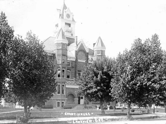
In 1909, as Lake County prepared for the arrival of the railroad and anticipated a population boom, optimism ran high. That March, the Lake County Examiner declared the region “the future garden spot of the Northwest.”
To support this expected growth, an elegant multi-story courthouse was constructed, pictured here. A defining feature of the building was its prominent clock tower, which housed a four-faced clock and a set of chimes crafted in Baltimore.
In 1954, the original courthouse was replaced by a modern, single-story structure made of steel and concrete. Sadly, the historic clock and chimes were not preserved during the transition.
Bullard Canyon / ~ Mile 0 to 2

Bullard Canyon is named for M.W. Bullard who settled along Bullard Creek in 1869.
In 1874 Lake County was created and in 1876 an election was held to determine the county seat. Prior to the election Bullard offered to donate 20 acres in Goose Lake Valley for a county courthouse. Following the election, which moved the county seat to the newly created town of Lakeview, Bullard sold 300 acres to John Moon who filed a town plat with the state and officially created the town of Lakeview.
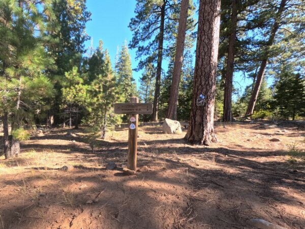
Bullard Canyon F.R.S. / ~ Mile 1.8

Located only two miles from Lakeview is a 35 foot tall sluice gate dam officially titled Bullard Canyon F.R.S. The dam’s name relates to its primary purpose with F.R.S. standing for Flood Retention Structure.
The importance of the dam was never more apparent than in 2019 when snow melt and heavy rainfall caused water to crest the spillway. Water and debris washed down Bullard Canyon and onto Center Street into Lakeview. Numerous roads in Lakeview were closed due to the flooding but thanks to community members’ efforts through the night damage was limited.
Camas Prairie / ~ Mile 4

Nestled between Drake Peak to the north and Crane Mountain to the south, Camas Valley comes into view on the initial climb of the ride. At ~ mile 8.6 you descend into the valley.
Fremont-Winema National Forest / ~ Miles 4 to 30

This forest is primarily composed of Ponderosa pine (Pinus ponderosa), a species uniquely adapted to thrive in fire-prone environments.
Thick, Fire-Resistant Bark: Mature Ponderosa pines develop thick, corky bark that insulates the vital cambium layer from heat damage during low-intensity surface fires.
Self-Pruning Lower Branches: These trees naturally shed their lower branches as they mature, reducing the risk of fire climbing from the ground into the canopy.
High Canopies and Open Crown Structure: The open crown structure and elevated canopies allow for better air circulation and heat dissipation during fires, decreasing the likelihood of crown scorch.
Fire-Adapted Regeneration: Ponderosa pine cones can release seeds in response to the heat from fires, facilitating regeneration in the nutrient-rich, fire-cleared soil.
Oregon Timber Trail / ~ Mile 8.5 and 15
The Oregon Timber Trail (OTT) is a premier long-distance mountain biking route that spans the state of Oregon, running from the southern border near California to the northern border near Washington. Covering approximately 670 miles, the trail is divided into four tiers—Fremont, Willamette, Deschutes, and Hood—each with its unique landscapes, challenges, and highlights. It traverses a mix of rugged singletrack, gravel roads, and forest trails, offering riders an immersive journey through Oregon’s diverse ecosystems, including high desert, dense forests, alpine lakes, and volcanic terrain. It crosses our route at the top of the climb and again at mile 15.
Drake Peak / ~ Mile 15.5
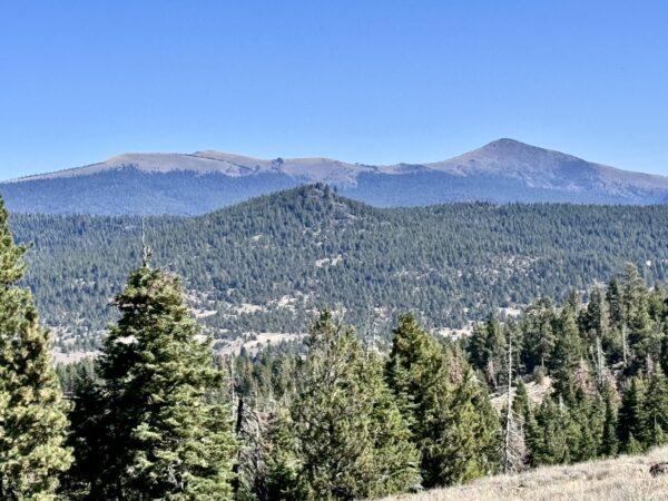
Visible to the northeast is Drake Peak an 8,399 foot mountain in the Warner Mountain Range. Drake Peak is part of a volcanic complex that last erupted over 5 million years ago.
Just to the west of Drake is Light Peak on which the US Forest Service maintains a fire lookout named Drake Peak Lookout. The lookout sits at 8,222 feet and has views over Oregon, Nevada and California. The lookout is the highest in Oregon that can be driven to and is the destination of another Dirty Freehub ride which can be found at this link.
Crane Mountain / ~ Mile 20

Crane Mountain, the tallest peak in Lake County, stands southeast of Lakeview and can be seen to the south from Drake Peak Lookout and along parts of the return on this route.
On its western side, overlooking Goose Lake, Crane Mountain reveals its two main rock types. The mountain is primarily composed of basalt, a dark volcanic rock. Beneath this basalt layer lies the John Day rhyolite tuff formation, a lighter-colored rock created from hardened volcanic ash. Both rock layers became visible when fault block movement tilted the formations, giving shape to the mountain.
Ruby Pipeline / ~ Mile 21.5 and 24

The Ruby Pipeline, completed in 2011, is a 680-mile natural gas pipeline transporting gas from Wyoming to Oregon, designed to meet growing energy demands in the West. Developed by El Paso Corporation, it later faced challenges when its operator, Ruby Pipeline LLC, filed for bankruptcy in 2022, leaving the project’s future uncertain. The pipeline’s struggles deeply impacted Lakeview, Oregon, where it brought initial economic benefits but left the town grappling with the financial fallout and a loss of local investment. Listen to this Oregon Public Broadcasting story from July 2011 for some initial perspective.
Lakeview Museums / @Finish
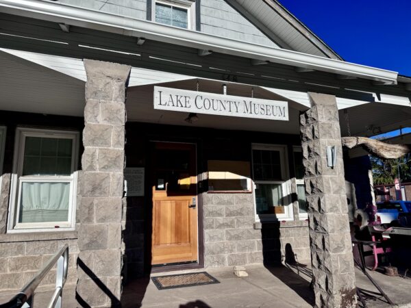
Lake County Historical Museum and Schminck Memorial Museum are near the start / end of this ride, just south of the courthouse on South E Street. The Lake County Historical museum is located in a house built in 1927 by Mr. and Mrs. Ike Kent. All the cement blocks were hand made by them. The adjacent Schminck museum served as a residence for a couple who has lived in the community since 1922.
“These museum are the best kept secret in town! There are many artifacts including ones found in an ancient cave over 6000 years old. The Modoc history room has a unique display of baskets & quill work. Not to be missed if you’re in town!” LindaH
Credits & Acknowledgements
This ride guided is funded in part by Travel Southern Oregon.
When We Like to Ride This
Spring and fall offer breathtaking displays of color—spring bursts to life with vibrant wildflowers, while fall dazzles with the rich hues of changing leaves. However, we would not hesitate to do this ride in late summer, the gravel is so good!
Terrain & Riding
The Terrain
High mountain meadows, ponderosa forests, and clusters of aspens. Willows and sagebrush weave through the landscape, dotted with a few junipers and vibrant seasonal wildflowers.
The Riding
Bullard Canyon Sector / Miles 0 to 8.5
- The route begins with an approximately 6.5 mile climb that averages 4.5% and has a maximum grade of 14%.
- The gravel is generally very good. There is one rough, rutted section that should be remembered for the return descent.
- The surrounding terrain varies from the narrow canyon, to open views and forests. At approximately mile 4 Camas Valley open up below and Drake Peak can be seen to the north. Here the ride is an undulating traverse that is super fun riding.
- At mile 8.5 you arrive at Rogger Meadow Trailhead and the end of the stick portion of the ride.
- There is a vault bathroom at the trailhead
Camas Valley Loop Sector / Mile 8.6 to 24.5
- The descent to Camas Valley begins on pavement. The road is narrow so be alert for uphill traffic and these are open range lands. Our group came across cattle crossing the road.
- Once in Camas Valley you have a short section of flat pavement before making a right turn at mile 13.4 and returning to gravel. There is a sign for Summit Prairie Rd at this intersection.
- The second climb of the day commences soon after this turn. The climb is 1.8 miles long, averages 6.75% and has a maximum grade of 13.7%. Most of the gravel is good. There were short sections of deeper gravel. There are open views to the north and Warner Range.
- Once over this climb the ride remains primarily forested as it rolls, often times fast, towards the base of the climb that will return you to Rogger Meadow Trailhead.
- This final climb ascends at an average grade of 4.2% over 2.9 miles and has a maximum grade of 9.7%.
Bullard Canyon Descent / mile 24.5 to 35
- The gravel is good and for most of the next 8.6 miles you’ll be rolling downhill! This is some of the best riding of the day.
- Remember the one section of rockiness from the ascent and stay to the right to allow for quads and vehicles that may be coming up the road.
The Start
Swimming Pool City Park on North D Street. During the summer season there are public restrooms.
Food & Water
- None.
Route Notes
We recommend a red blinking light, like a Garmin Varia, for the ride up Bullard Canyon. During our ride there were a few quads and 4-wheel drive vehicles using the road. Share the road with respect and a wave!
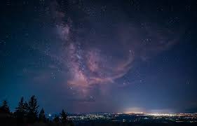
This area is part of the Oregon Outback Dark Sky Sanctuary. If you have the opportunity, spend an evening or a night camping in the backcountry. There is Camas Snowpark (just north of mile 13.5) that you can drive to and look at the night sky and there is Twin Springs Forest Camp (at about mile 23 of the route).
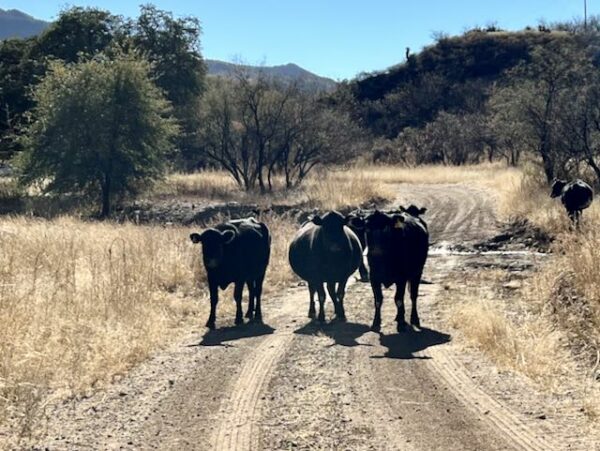
Near Camas prairie you will encounter open grazing. Please review Tips & Tricks page on how to pass by cows and cattle without incident. Riding through and whooping and hollering is not the way!
Route Options
Shorter Option
This route is a lollipop so you can shorten it, and eliminate the opening climb, by driving to the loop and parking at Camas Sno-Park just of highway 140. Lat/Long: 42.226506, -120.231734
- Camas Valley Loop
- ~ 16 miles and 1,300 feet of climbing
Longer Options
Drake Peak Out & Back
- At ~ mile 13.5 this route arrives at NF-3615. If you turn left at this intersection (versus right to complete Camas Valley Loop) you will arrive at the start of another Dirty Freehub route, Drake Peak Lookout, within a mile.
- Connecting both routes into one ride nets approximately 61 miles with 6,200 feet of climbing.
Bullard Canyon (Long)
- At ~ mile 13.5 this route arrives at NF-3615. If you turn left at this intersection (versus right to complete the Camas Valley Loop) you will embark on the long option.
- 52 miles with 4,000 feet of climbing. Map. Download GPX File.
- Note, we have not ridden the long option. Thus, be ready to explore and turn around if necessary. If you do ride the long option, please leave us a comment in the ride guide or send us an email at info@DirtyFreehub.org
Love Where You Ride! Learn More
 Lakeview was established in the 1860s. The area was initially populated by ranchers and homesteaders seeking fertile land in southern Oregon.
In 1900, a fire destroyed most of Lakeview’s business district, including over 50 businesses, the town hall, and two fraternal lodges. The fire was so intense that it was visible from Klamath Falls, 75 miles away. The town was rebuilt and by the early 1900s Lakeview had become a bustling small town with essential infrastructure, including schools, churches, a bank, and a newspaper, reflecting its growth as a regional center. Agriculture was the main economic driver for Lakeview and the surrounding region. The fertile soil, water from nearby lakes and streams, and ideal climate for grazing livestock made Lakeview a key hub for ranching and farming. It was also a supply center for some of the region’s gold mines.
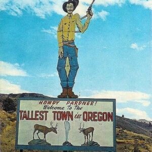
Today, Lakeview has a population of approximately 2,500 residents. It is known for its close-knit community, outdoor recreation opportunities, and historical charm. At 4,798 feet above sea level, Lakeview also lays claim to being the tallest town in Oregon.
Podcasts
Wolf Lichen: It's not a Harry Potter spell ... it's Letharia Vulpina
Do you ever see some bright green, shrubby looking creature on a gravel ride? This organism is likely Letharia Vulpina (and no it does not have magic or poisonous powers like a spell) which is also knows as Wolf Lichen. Bryologist, mycologist, and lichenologist Tim Wheeler works to [...]
Be Informed!
Keep it Local! Learn More

Ridden and Reviewed by:

 Behind every route is scouting, mapping, storytelling, and a whole lot of pedal power.
Have you ridden this route? Got a question? Join the discussion!