Schoolhouse Peak Lookout


Caution! We do not provide turn-by-turn directions in our GPX files. Those are auto-generated by your bike computer and are usually less than 70% accurate. Learn more.
For help loading a GPX file onto your bike computer, go here.
DownloadWhen We Like to Ride This
The weather in this part of the country stays fairly consistent, with generally cool and dry summers and mild and wet winters. Depending on what kind of weather you like riding in, this could be a year round experience, although expect barren trees and windblown prairies at the top of you’re choosing to ride in the winter months.
Terrain & Riding
Terrain Overview
This route unfolds across three distinct landscapes: towering redwood forest, oak-dotted woodland, and expansive rolling grasslands. This open prairie and oak-savanna mosaic supports bird species rarely seen elsewhere in the park, including the reintroduced California condors.
Redwood Forest (Start to ~9.5 mi)
Ride deep beneath giant redwoods on shady, paved, but rough, forest roads.
Oak Woodland & Summit Transition (~9.5 – ~15 mi)
At mile 9.5, reach the gravel section that quickly forks. Take the left branch climbing steadily toward Schoolhouse Peak. The final 0.5 miles is rough and steep—ranging up to about 13% gradient—so be prepared to walk if needed, especially on loose sections. Once you arrive, the panoramic view from the lookout is a rewarding payoff for the climb
Next, backtrack and descend on gravel roads and trail toward Lyons Ranch, descending around 400 feet along open prairie dotted with oak groves. The route here is gradual and manageable, with broad views over the Redwood Creek watershed and historic ranch structures set amidst wild grasses and prairie landscapes.
Route Notes
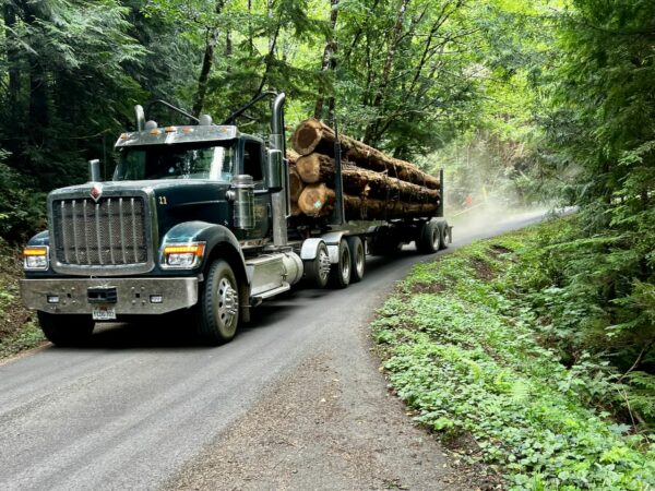
We recommend using a red blinky light with a rear-facing radar detector (like a Garmin Varia or Trek Car Back). Bald Hills Road is shared by many park visitors and the occasional logging truck. To learn more about riding safely and with respect in active timberlands, see our Timberlands Riding Etiquette resource page.
Yes, you can ride a bike from the Lyons Ranch trailhead to the historical barn. We have checked with the Park Service! Please ride cautiously, because this area statistically has the most bear sightings, and you wouldn’t want to surprise one coming around a bend on the trail.
Route Options
Longer
For a longer and more demanding ride, start at the Redwood Creek Trailhead parking area. Climb the entirety of Bald Hills road. This option adds 13 miles and 2200 feet of gain. It also adds several historic kiosks along the way.
Lat/Long: 41.299218, -124.033534
Love Where You Ride! Learn More
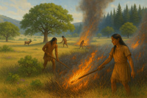 For thousands of years, the The Yurok, Karuk, and Hoopa peoples shaped the Bald Hills through deliberate, seasonal fires. They used carefully timed burns to clear dense underbrush, restore nutrients to the soil, and prevent conifer trees—cone-bearing evergreens such as redwoods, cedars and pines—from overtaking the open grasslands and oak woodlands.
One of their main goals was to help Oregon white oak and California black oak grow. The acorns from these trees were an important food source. By burning competing plants in the fall after harvesting acorns, the tribes increased acorn production and reduced damage from insects.
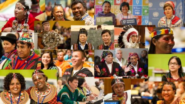
Today, the Nature Conservancy, the National Park Service, and others are working with tribal partners to bring back controlled burns at places like Lyons Ranch, restoring the land’s health and honoring traditional ecological knowledge.
Learn more about this story in this quick read, “Quiet Fire: Indigenous tribes in California and other parts of the U.S. have been rekindling the ancient art of controlled burning.”
Podcasts
Log Trucks: Rider Safety Part I
In this episode, the Dirty Freehub team goes on a tour to Alder Creek Tree farm with Jennifer Beathe, Forester and Outreach Manager of Starker Forests. During the ride to Alder Creek Tree farm in Corvallis, Oregon, we dive into identifying the recreational and rider safety around logging [...]
Log Trucks: Rider Safety Part II
This episode is part of our logging series, which covers topics such as safety, education, and what we need to know as recreationalists in active logging areas. In this episode, we connect back with Jennifer Beathe, Forester and Outreach manager of Starker Forests and Austin Finster, owner [...]
Route Development and Exploratory Routes
Find out what goes into gravel route development and what it’s like to do a Dirty Freehub exploratory route. Sometimes all goes well, other times it is an adventure and maybe even epic. Special guests Michelle and Gatum share their stories with us!
Be Informed!

Have you ridden this route? Got a question? Join the discussion!