Pozo Nuevo


Highlights & Remarkable Spots
The Start / Mixed: Paved and Hard-pack gravel / ~ Miles 0 to 5
From the visitor center, head northwest on Puerto Blanco Drive, which initially is a two-way road alternating between paved and gravel sections. Within a mile, you’ll get your first good look at organ pipe cactus, but here, they’re outnumbered by saguaros and ocotillos. To the northwest is Pinkley Peak. It will feel at times like it is far to the right. But, in fact, you will pass to the north of the peak. It is the highest point in the Puerto Blanco Mountains, named for Frank Pinkley, a National Park Service superintendent who was key to the monument’s formation.
North Puerto Blanco Road / Primitive 4 wheel drive road, one-way / ~ Miles 5 to 22.5
Next, the route becomes a one-way dirt road. It also turns much more rutted as it dips and winds through the desert landscape. But in between the rough sections are relatively smooth stretches that allow you to fully enjoy the scenery.
A small hill at mile 10 offers great views over the valley, the mountains and the road itself – a perfect wilderness scene. After here the track becomes a little more steep and uneven, bending sharply to the left then back right as it crosses the edge of the Puerto Blanco Mountains.
Around Mile 11 there are numerous organ pipe cactus, surrounded by an cathedral-like rock formations on the left. Organ pipe cactus are “relative newcomers to Arizona: They arrived just 3,500 years ago, as the planet thawed after the last ice age. To the northwest, the flat-topped Cipriano Hills form the backdrop for the cactuses’ silent symphony, which you can stop to enjoy at multiple picnic areas (including the now-shuttered Golden Bell Mine, at Mile 17).” [Arizona Highways]
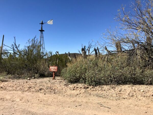
Around mile 20, you come to Bonita Well. This spot houses an abandoned water tower (old school “windmill”) and a cattle corral. After this spot, the immediate scenery becomes less dense and more open, with larger rock formations now in the distance.
About a mile beyond Bonita Well, there is a fenced off area to your right with an antenna tower, some solar panels, and a large propane tank. The next 1/4 to 1/2 mile is the most difficult part of the ride (as of February 2021). The road turns to loose and deep pebble gravel. It doesn’t last long, but it was a workout on 42 mm tires. I walked a few of the worst sections for a total of no more than 2 minutes of walking. Prepare for a short hike-a-bike if needed—it won’t ruin your day.
Pozo Nuevo Road / Gravel / ~ Miles 22.5 to 36
At ~ mile 22.5, the Puerto Blanco Drive road ends at a T intersection. Go right on Pozo Nuevo road. In researching the route, we found little information about the road conditions. But we do know that it offers views of the Cipriano Hills, the Growler Valley, and the historic Pozo Nuevo well and line-camp.
Pozo Nuevo Well was the oldest hand-dug well in Organ Pipe, dating from 1910. It is located at one of the fifteen ranches and line camps of the Gray family cattle business which dominated the lands of Organ Pipe National Monument for nearly 60 years. The Grays, Robert Louis, Sr., and sons Robert, Jr., Henry, and Jack, began the trend of buying up water rights, ranches and line camps in 1919. They utilized the open range via a trigger gate to lure their cattle to water in their corrals at round-up time and made do with the materials they had at hand since supplies were hard to come by. [Desert Mountaineer]
Bates Wells Road / Gravel / ~ Miles 36 to 49.5
Bates Well road is has undergone significant improvement since the construction of the “new” border wall from 2016 to 2020. However, the exact conditions of the road are unknown along with the texture and quality of the scenery. This section of road has been reported to have sections of washboard.
Double-track / Primitive Dirt Road / ~ Miles 49.5 to 57
At mile 49.5, the route splits from Bates Well road and follows a double track along the the eastern flank of the John the Baptist Mountains. This section is the major unknown of the ride. There is very little “heat” on the Strava and other mapping resources but the road / double-track shows up on satellite imagery. (If it is a no go, double back to Bates Wells road and follow it north until it intersects Scenic Drive.)
Scenic Drive / Hard-packed Gravel Road / ~ Miles 57 to Finish
At mile 57, the route connects with a proper gravel road which soon meets up with Scenic Drive. From here it is hard-packed fast gravel with great views of Ajo Peak and North Ajo Peak. Very near the finish, take the time to make a quick stop at the Ajo Historical Society museum and the New Cornelia mine lookout.
When We Like to Ride This
… fall through spring when the temperatures are more moderate.
Terrain & Riding
With more than 3,500 native plant species, the Sonoran Desert has the most plant life north of the tropics. Some of the common types of plants in the Sonoran Desert include saguaro, cholla, prickly pear cactus, ocotillo, mesquite, ironwood, and palo verde. In such desolate conditions, cacti fruits ensure the abundant wildlife a reliable food source. In contrast, mesquite and palo verde trees provide must-have shade for our feathered, furry, and scaly friends.[Gaia Provides]
The route starts by circling north and west of the Puerto Blanco mountains and then traverses east to west on the south side of the Cipriano Hills and Bates Mountains. At the intersection with Bates Well road, the route turns north, passing through Growler Pass and then juts west and follows the east side of the John the Baptist mountains the little Ajo mountains, near the town of Ajo.
The Start
Kris Eggle Visitor Center. Flush toilets and water.
Food & Water
- None.
Route Notes
As an exploratory route, we recommend 50+ mm tires. Also, a personal locater beacon like a Garmin inReach or Spot device is highly recommended.
There are some sections with jumping cholla along the gravel roads, so … be careful! And carry a flattened metal fork … the best tool for removing one from your skin.
Other References
The following two reviews of Puerto Blanco Driver are worth a few minutes of your time.
The following two articles have interesting information on the early 1900’s ranching that took place:
Keep it Local! Learn More

Have you ridden this route? Got a question? Join the discussion!