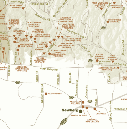
Chehalem Vineyard Tour


We think the northern part of the Willamette Valley is really under appreciated for the great gravel riding that it has. The terrain is rolling hills through farmlands, woodlands and vineyards. This ride features the Chehalem Valley and the Chehalem Mountains, an important and prosperous American Viticultural Area (AVA).
“The Chehalem Mountains AVA is a single uplifted landmass southwest of Portland in the northern Willamette Valley, extending 20 miles in length and 5 miles in breadth, stretching from southeast to northwest. It includes several discrete spurs, mountains and ridges, such as Ribbon Ridge and Parrett Mountain.
The highest point within the Willamette Valley is the Chehalem Mountains’ Bald Peak (at 1,633 feet) affecting weather for the AVA and for adjoining grape growing hillsides. It is the geography and climate that differentiate this AVA from others.
All three important hillside soil types are represented: basaltic, ocean sedimentary and loess (blown lake bed sediment), the predominant soil on the northern face of the Chehalem Mountains. Within the almost 70,000 acres of this AVA are over 2,600 acres of grapes, grown in over 179 vineyards, and 53 wineries.” [Willamette Valley Wine]
Quick Facts
- Established: 2006
- Wineries: 53
- Tasting Rooms: 34
- Vineyards: 179
- Total Area: 62,187 acres
- Planted Area: 2,685 acres
- Most common grape varieties: Pinot noir (69.89%), Pinot gris (3.79%), Chardonnay (3.75%)
Along your ride, there are few long sustained climbs, but the hills do come with pitch. Seeing your bike computer read out 8% or 10% or even 15% incline is not uncommon. Overall, we found the roads to be hard-packed. Sometimes smooth, sometimes with a layer of pea gravel over the top.
The Dirty Freehub Team has ridden this entire route, but in the opposite direction of that documented here. It is an absolute 5 Star ride, but we need to add more documentation and the multimedia elements before publishing it out as such. If you’ve ridden some or all of this route, any feedback you have would be much appreciated. You can leave it below in the comments block.
Caution! We do not provide turn-by-turn directions in our GPX files. Those are auto-generated by your bike computer and are usually less than 70% accurate. Learn more.
For help loading a GPX file onto your bike computer, go here.
DownloadHighlights & Remarkable Spots
Monarch Butterfly Area / Gravel / ~ Miles 4.8 to 5.8
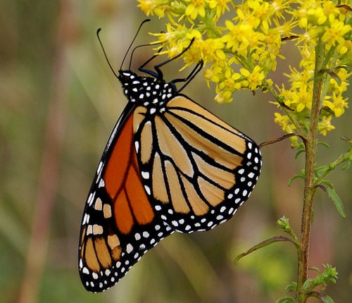
This sector marks a joint effort by the USDA’s Natural Resources Conservation Service (NRCS), the U.S. Fish and Wildlife Service (USFWS) and private landowners improve Monarch habitat in Oregon’s Willamette Valley.
“Monarch butterfly populations have decreased by 90 percent worldwide since the mid-1990’s, mainly due to a lack of suitable habitat. The monarch’s primary habitat in the Willamette Valley is native prairie with milkweed — a leafy, green plant with pink, nectar-rich blossoms. Milkweed is unique because it’s the only plant that monarchs will lay their eggs on, and it’s the only food source for monarch caterpillars.” [USDA Natural Resources Conservation Service]
When We Like to Ride This
The Willamette Valley area rides most of the year. Winter can be wet, but spring is absolutely beautiful with the flowers, blooming trees, green fields and flowing creeks.
Terrain & Riding
Some notes on the riding.
Ribbon Ridge Road / Gravel / ~ Miles 6 to 10
Ascent and descent of Ribbon Ridge, home to a number of wineries (Map). The front side gravel road is treated and very hard-packed, as good as a paved road. The backside descent is steep at ~ 7% for just under a mile.
Kings Grade Climb / Paved / ~ Miles 12.6 to 13.2
A short, steep, paved ascent. Gradients of 8 to 14%.
Holly Hill Road / Gravel / ~ Miles 13.2 to 16.5
The next 3 miles are through woodlands. It starts with a steep gravel descent that averages over 9%. This is the most technical riding section of the day. The remaining miles of this gravel sector are rolling and fun riding.
The Neighborhood / Paved / ~ Miles 16.5 to 20
Paved, undulating riding with a downhill trend and a fast finishing descent. This area was more densely populated than the rest of the ride, some homes and hobby farms.
Finnigan Hill / Gravel / ~ Miles 20 to 23
A 3.2 mile moderate ascent of 1000 feet through old growth / mature forest. This is the longest gravel climb of the day and one that we found to be very scenic.
Vineyards & Farms / Gravel (mostly) / ~ Miles 25 to 28
A mostly gravel sector with the steepest pitch at the beginning and then leveling off near the end. There are vista views of the vineyards, ranches and farms. Quite scenic.
The Start
A parking kiosk at the intersection of the intersection of Sunnycrest Road and Hidden Springs Road.
Food & Water
- None.
Route Notes
We recommend a red blinky light. Overall, the traffic is light with the exception of two short 1-mile segments on Highway 240 that come at the beginning and end of the ride (single file riding recommended).
Route Options
Alternate Start
Using the alternate start marked on the map (at approximately mile 6.5) you can avoid the two Highway 240 sectors. Just past mile 27 continue straight on Northeast Valley Road instead of turning left. It is paved and will bring you back to the start. However, it will still have some traffic requiring single-file riding. If you do this version, please leave us a comment on what you experienced. Route: 23 miles, 3100 feet of gain.
Other rides in the area to consider are:
- Yamhill Loop / 5 Star Route
- Yamhill 8 / Development Route
- Ghost Hill / 5 Star Route
- G-Man / Development Route
- McMinnville Mayhem / Development Route
- Powerhouse / 5 Star Route
- Chehalem Vineyard Tour / Development Route
From this collection of routes, you can build longer and more challenging routes, but you can also shorten routes to your liking. See our 20 Minutes series on “How to Modify Routes with RideWithGPS“.

 Behind every route is scouting, mapping, storytelling, and a whole lot of pedal power.
Have you ridden this route? Got a question? Join the discussion!