Pure Sonoran


Caution! We do not provide turn-by-turn directions in our GPX files. Those are auto-generated by your bike computer and are usually less than 70% accurate. Learn more.
For help loading a GPX file onto your bike computer, go here.
DownloadHighlights & Remarkable Spots
Crested Saguaro / On Drive to Start
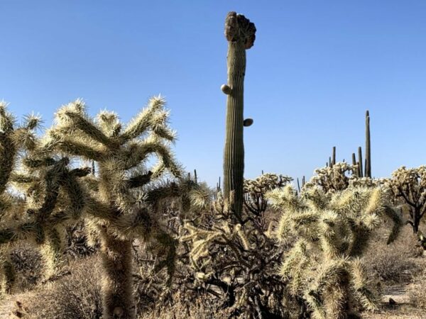
The drive in to the start on the Florence-Kelvin Highway has one of the highlights of the day – a crested saguaro cactus!
Saguaros sometimes grow in odd or misshapen forms. The growing tip occasionally produces a fan-like form which is referred to as crested or cristate. Though these crested saguaros are somewhat rare, over 25 have been found within the boundaries of Saguaro National Park. Biologists disagree as to why some saguaros grow in this unusual form. Some speculate that it is a genetic mutation. Others say it is the result of a lightning strike or freeze damage. At this point we simply do not know what causes this rare, crested form.
The Boulders / ~ Mile 42
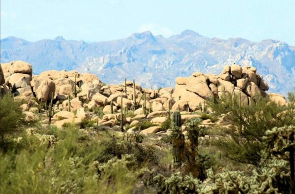
If you want (and we recommend it!) to explore the Boulders, go right onto Cochran Road at ~ mile 42. In a couple of hundred yards you will come to a parking lot at the base of the Boulders. Note, in recent years The Boulders have been vandalized with graffiti. (It has since been cleaned up.) If you see any illegal activity, please contact the local sheriff’s office via 911.
When We Like to Ride This
Excellent ride during the coldest time of year in the desert. I did this in December and the weather was beautiful. During the shoulder months you could definitely catch some heat so be sure to pack enough water. I would not recommend riding this route during the summer months (June-September).
Terrain & Riding
This route begins about 20 miles east of Florence and is fun from beginning to end!
Miles 0 to 20.5 / Bakersville and Freeman Roads / Gravel
Starting at about 2500 feet elevation, Barkerville Road. is a smooth, hard-packed dirt road that leads you on a steady incline of 1 to 2% to the high point of the route [~ mile 16.5] at just over 4000 ft. The beautiful desert landscape will keep you visually stimulated during your ascent as Black Mountain in the distance draws nearer.
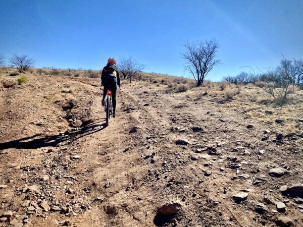
Miles 20.5 to 33 / Arizona Trail / Single-track & double-track
This sector [the Arizona Trail Passage 15: Tortilla Mountains, from the Freedman Road trailhead] is the highlight of the route, more than 10 miles of Arizona Trail single track that winds and weaves through pristine Sonoran desert of Saguaros, Prickly Pears, Chollas, and Yucca variants. It feels as if you’re riding through a desert botanical garden!
The AZT is one of 11 National Scenic Trails in the U.S., an elite group that includes the Appalachian and Pacific Crest pathways. It is a complete non-motorized path, stretching 800 diverse miles across Arizona from Mexico to Utah. It links deserts, mountains, canyons, forests, communities and people.
After a quick jaunt on double-track, you’ll stay on single-track until Tecolote Road at mile 33. The trail is mostly on a downhill grade and pretty smooth, especially at the beginning. You don’t want to get going too quickly though, as the cactus impede the trail like arms at the corners. Wind and weave your way with happy caution it. Towards the end of the singletrack, you’ll climb the side of a small mountain (hill?) which gets a bit chunky but other than that, the terrain is pure.
Miles 33 to 38.5 / Tecolote Road / Dirt Road
At mile 33, go left on an unnamed dirt road. This is a short connector to Tecolote road, where you go right. It is a dirt road leading back to the Florence-Kelvin Highway that feels like a wash most of the way and can be quite sandy. There were a couple of times where I didn’t have enough speed going through and had to dismount.
Miles 38.5 to Finish / Florence-Kelvin Highway/ Gravel to Paved
The final stretch of road, the Florence-Kelvin Highway, is easy-going as it’s smooth and downhill. You’ll pass the Joshua tree like Boulders area at about mile 42. Then, you’re quickly back to the start!
If you want (and we recommend it!) to explore the Boulders, go right onto Cochran Road at ~ mile 42. In a couple of hundred yards you will come to a parking lot at the base of the Boulders. Note, in recent years The Boulders have been vandalized with graffiti. (It has since been cleaned up.) If you see any illegal activity, please contact the local sheriff’s office via 911.
The Start
Makeshift dirt parking lot at the Intersection of Florence-Kelvin Highway and Barkerville Road.
An alternate start, and possibly better start as discussed in the comments, is at the Freeman AZT trailhead. The trailhead can be accessed from Dudleyville or via Willow Springs Road between Oracle Junction and Oracle. Both approaches involve driving some distance on gravel road. This option, puts the most technical riding at the frong half of the ride, versus the latter half: Lat/Long: 32.870998, -110.882056
Food & Water
- None
Route Notes
This route is rugged and demanding. Don’t expect smooth, easy “Cadillac” gravel—plan for your ride time to take 25–50% longer than usual. Come prepared! For tips and advice, check out our Resource Page: Riding in the Desert Southwest.
We recommend a red blinky light with rear looking radar detector (i.e. Garmin Varia)
Be Informed!
Ridden and Reviewed by:

 Behind every route is scouting, mapping, storytelling, and a whole lot of pedal power.
Have you ridden this route? Got a question? Join the discussion!