Japanese Hollow


Caution! We do not provide turn-by-turn directions in our GPX files. Those are auto-generated by your bike computer and are usually less than 70% accurate. Learn more.
For help loading a GPX file onto your bike computer, go here.
DownloadHighlights & Remarkable Spots
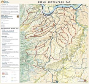
Sorosis Park / Beginning & End of Ride
Sorosis Park was founded by the local chapter of the Sorosis Club. The club, founded in 1869, was the first national all-womens group. Soror, in latin, means sister (think “sorority”), and the word “sorosis” is a Greek word used to describe multiple fruit formed from many flowers.
In addition to founding its namesake park, the local chapter of the Sorosis Club founded both City Park and the Carnegie Library. They also saved the Fort Dalles Surgeon’s Quarters from demolition. This building now serves as The Fort Dalles Museum. [Columbia Community Connection]
Three Mile & Five Mile Roads / ~ Miles 1.5, 8.5
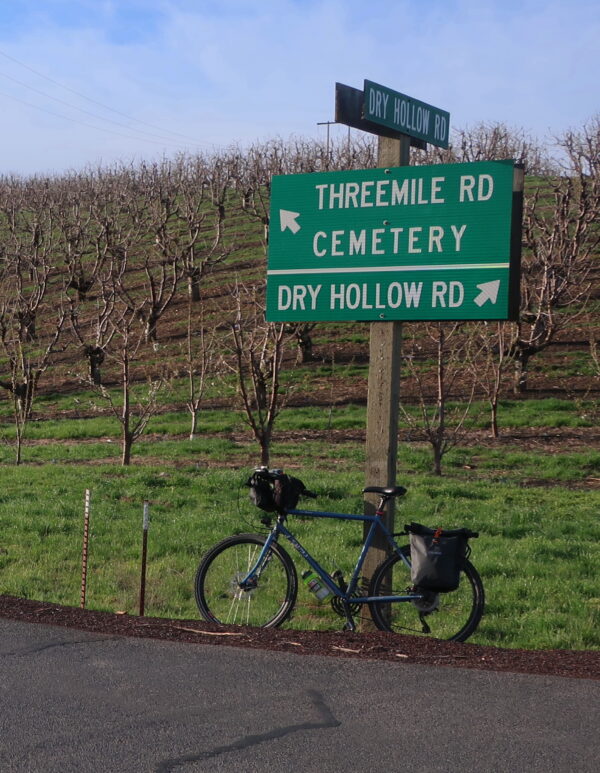
Many of the roads and creeks in the area make reference to distances. Three Mile and Five Mile Roads, for example — as well as nearby Eight Mile and Fifteenmile Roads — were named to identify the distance settlers had to travel from The Dalles. [Wikipedia]
Mt Hood / ~ Miles 13-17
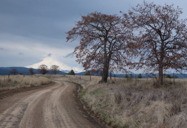
As you travel along Pleasant Ridge, enjoy views of Mt Hood in the distance. Standing 11,239 ft tall, the mountain is the highest in Oregon. It contains 11 glaciers and is the second most climbed mountain in the world after Mount Fujiyama in Japan. A dog named “Ranger” allegedly climbed the mountain 500 times during his 14-year life. The dog is buried on the summit. For other interesting facts, visit this webpage.
Obrist Pioneer Cemetery / ~ Mile 31
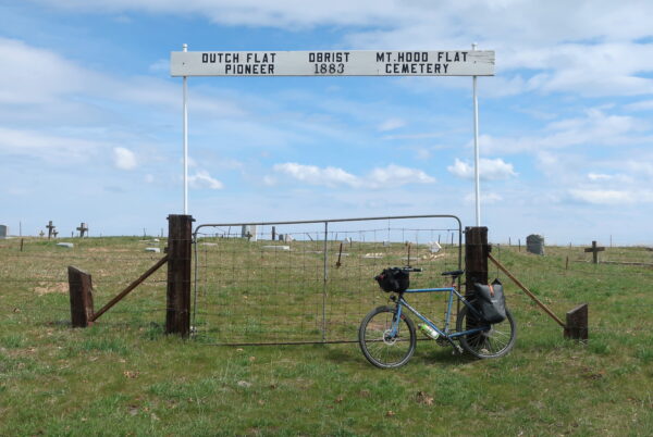
One of the families that settled the Dutch Flat area was that of Jacob Obrist. His son, William was a Rural Free Delivery (RFD) service carrier circa 1910.
The RFD system had many opponents. Most important were the four rich, powerful express companies that monopolized the delivery of valuable or time-sensitive packages. They “arrogantly served the public, rendered only mediocre service, [and] made inordinate profits.” They were unregulated and confused customers with myriad rates. Furthermore many politically connected town merchants worried that the service would reduce farmers’ weekly visits to town to obtain supplies, or that Sears, Roebuck and Company with its catalogs would undermine their local business. The opponents mounted a fierce opposition to the use of parcel post, delaying full implementation for a number of years.
This cemetery is also known as Dutch Flat, Mt Hood Flat, and Three Mile Cemetery per the Oregon State Historic Cemeteries list.
Cherry Orchards / Near beginning and end of ride
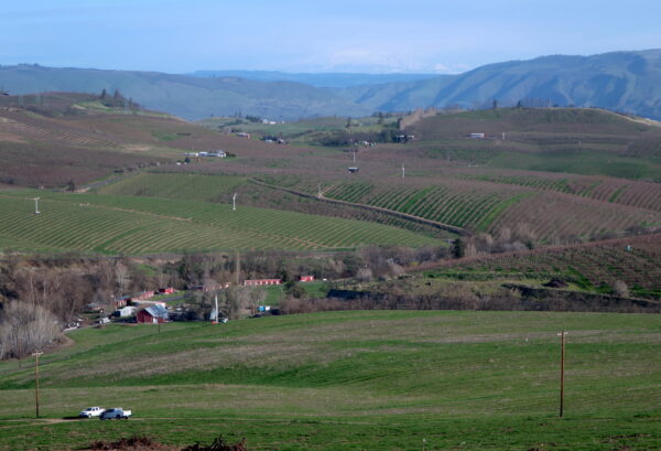
As you begin and end the ride, you’ll cycle past miles of orchards. Cherries are big in The Dalles. The Oregon Cherry Growers is one of the area’s main employers, and Orchard View Farms is the largest cherry grower in the state.
For decades, the local Harvey Aluminum smelter contributed significantly to the economy. However, the industry caused significant environmental damages to cherry crops from its toxic fluoride emissions. In 1987, the smelter was listed as a Superfund site. The Environmental Protection Agency (EPA) began cleaning up the site two years later, and the site was removed from the EPA’s National Priorities List in 1996. [Oregon Encyclopedia]
Long live the cherry orchards!
Credits & Acknowledgements
This route and Ride Guide was inspired by Our Mother The Mountain’s Japanese Hollow Reverse Variation with Pleasant Ridge Cutoff route.
When We Like to Ride This
Early spring and late fall are great, especially when the temps are moderate and pleasant. Riding in the summer is doable, but an early morning start is advised due to the heat. Be aware of snow at higher elevations in the winter months, as the maximum elevation is 2900 ft.
Terrain & Riding
This ride promises a diverse and scenic gravel riding experience that will leave you in awe of the stunning landscapes of Wasco County and the Columbia River Plateau. Enjoy luxurious gravel roads and ever-changing scenery as you journey through hills, hollows, ridges, highland bluffs, and lowland valleys.
The ride begins with a picturesque ascent through cherry orchards and oak covered hills, gradually climbing above Japanese hollow (to your left) to the edge of the Mount Hood National Forest where you will be surrounded by Ponderosa Pine and Douglas Fir trees, a stark contrast to the previous landscape.
As you reach the high point just beyond mile 22, the evergreen forest gradually gives way to scrub oak savannah of Pleasant Ridge and then after a descent and shorter climb to the rolling rangelands of Dutch Flat.
Lastly, enjoy a final, smile-inducing, gravel to paved descent with twists and turns bringing you back into The Dalles.
The first seven miles of the route are paved. After that, you’ll ride a bit of gravel and another bit of pavement before remaining off-tarmac for the next 30 miles. The final five miles have you back on pavement.
The majority of the climbing is in the first half of the route. The climbing is at a consistent and comfortable grade.
Though most of the gravel is in decent shape, you may encounter sections of mud following recent precipitation.
The Start
Begin at Sorosis Park on the bluffs of The Dalles. Restrooms are available. There is no parking permit or fee.
Food & Water
- None
Route Notes
Once you clear the town limits, it may seem as though you have all the roads to yourself. Keep your eyes peeled for and give way to agricultural and other traffic as bigger, heavier, and faster vehicles are not expecting to see cyclists. For safety, we recommend a red blinky light with rear looking radar detector like a Garmin Varia.
This section of the Columbia Gorge is known for its wind. Plan accordingly.
Love Where You Ride! Learn More
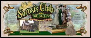 The Dalles held a five-day mural painting event in August 2022 called “The Northwest MuralFest.” During the festival, artists painted 18 new historical murals, including one honoring the Sorosis Club. Consider touring the murals downtown via either foot or pedal. Use this map as a guide.
Videos
Orchard View Farms
Orchard View Farms is located in The Dalles. The orchard, which has been owned and operated for generations by the same family, is the nation's largest sweet cherry farm.
Keep it Local! Learn More
Ridden and Reviewed by:

Have you ridden this route? Got a question? Join the discussion!