Hell of Hess


Caution! We do not provide turn-by-turn directions in our GPX files. Those are auto-generated by your bike computer and are usually less than 70% accurate. Learn more.
For help loading a GPX file onto your bike computer, go here.
DownloadHighlights & Remarkable Spots
Homestead Wilderness Study Area / ~ miles 3-12
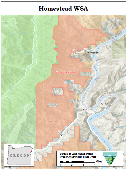
The Homestead Wilderness Study Area is just to your left along miles 3 to 12. The area is approximately 10 miles in length and reaches a width of 5 miles at its broadest point, narrowing to 400 yards at its slimmest. Home to wildlife, including habitat for Bald Eagles, the Homestead Wilderness Study Area provides an important transition zone between the mountain zone and the laval plains. The flora in the area is varied, featuring a mix of bunchgrass, cheatgrass, and wheatgrass, along with big sagebrush, elderberry, hawthorne, poison ivy, snowberry, Douglas fir, white fir, and ponderosa pine. The land in the WSA is home to predominantly old-growth forests, which grow in the wetter and flatter regions of the steep draws. [Bureau of Land Management]
Oxbow / ~ mile 7
Oxbow, Oregon is the southern gateway to the Hells Canyon Recreation Area. It’s name reflects the U-shaped bend in the Snake River named after this agricultural implement. The present-day community of Oxbow was established in the early 1960s near the former site of Copperfield during the building of the Oxbow Dam by the Idaho Power Company. The Oxbow post office was established on May 1, 1965, after moving the office from Homestead six miles to the north.
Oxbow Fish Hatchery / ~ mile 7
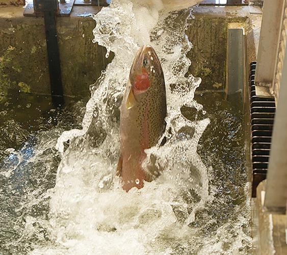
The hatchery was constructed in 1962 by Idaho Power Company as part of its operating license for Brownlee, Oxbow, and Hells Canyon dams on the Snake River. The Federal Energy Regulatory Commission requires Idaho Power to operate this facility to conserve fish runs that were impacted by the construction of the three dam complex. These dams were built without fish passage facilities with the idea that salmon and steelhead would be trapped and trucked around the dams. When this program failed, Idaho Power provided funds to build Oxbow Fish Hatchery. Idaho Power Co. is rebuilding the fish hatchery starting Spring of 2023. Work is expected to be completed the end of 2024.
Oxbow Dam and Power Station / ~ mile 7
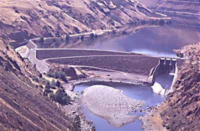
In the late 1950s, the Oxbow area experienced a revival when Idaho Power constructed three major dams on the Snake River: Brownlee Dam (completed in 1959), Oxbow Dam (completed in 1961), and Hells Canyon Dam (completed in 1967). According to Idaho Power, “in a normal water year, the three plants provide approximately 70% of Idaho Power’s annual hydroelectric generation and approximately 30% of the total energy generated.” Unfortunately, the Hells Canyon Complex dams do not offer a passage for migrating salmon, resulting in the blockade of anadromous salmonids’ access to a section of the Snake River drainage basin extending from Hells Canyon Dam up to Shoshone Falls, known as the upper Snake River basin. [Wikipedia]
The Copperfield Affair / ~ mile 7
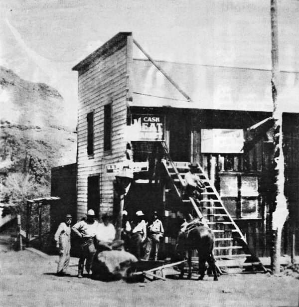
Despite having a marshal and a small jail with four cells, law enforcement in Copperfield was lenient. The second floor of the dance hall served as both the city hall and the jail. Saloons freely dispensed liquor on Sundays, and gambling was practiced without regard for Oregon’s prohibition laws. Organized brawls were commonplace, with competing groups of power-plant and railroad employees engaging in altercations that prohibited the use of knives or guns. Consequently, Governor Oswald West of Oregon ordered the imposition of martial law in Copperfield on January 2, 1914, by dispatching his private secretary (see this great video) and a team of five militiamen. This incident, known as the Copperfield Affair, garnered national attention. A year later, a massive fire destroyed most of Copperfield, and another blaze two years after that left only the post office and the schoolhouse standing. The post office shut down in 1927, the railroad ceased operations in 1931, and the school merged with Homestead in 1945. [Oregon Encyclopedia]
Northwestern Rail Company Tunnel / ~ mile 8
In 1906, the Northwestern Railroad Company was founded as a short-line railroad, laying tracks from Huntington, OR, along the Snake River. The preliminary work for this railroad spur included a 2,100-foot tunnel through the neck of the oxbow in the river. At the same time, the predecessor of Idaho Power Company began construction of the power plant that included a dam to divert water. In 1910 and 1911, the company was sold in two separate transactions to the OWR&N. It remains uncertain whether the 58-mile stretch of railway to Robinette, Brownlee, Copperfield, and Homestead was ever run independently or solely operated under the OWR&N. [National Railway Historic Society]
Homestead & Iron Dyke Mine / ~ mile 11
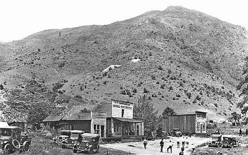
Homestead lies about 4 miles north of Oxbow. It was platted around 1898 along a Northwest Railway Company line that never developed. It thrived because of the patronage of the miners from the Iron Dyke Mine and because it was the railhead for local orchards. The community was named for the homestead claim of Frank E. Pearce. The Homestead post office operated until May 1, 1965 when it was relocated to Oxbow. Image circa 1915 – 1925. [Wikipedia]
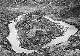
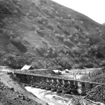
Snake River / ~ miles 7-14
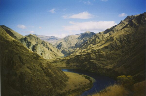
The Snake River originates in Wyoming and runs 1,078 miles to the Columbia. The Hells Canyon region of the Snake River are the ancestral lands of the Shoshone and Nez Perce tribes. According to the Nez Perce tribe, Coyote created the Snake River Canyon in a single day to shield the people on the west side of the river from the Seven Devils, a group of malevolent spirits living in the mountain range to the east. In the late 1800s, the military forcibly removed the Native Americans, and settlers began ranching and mining in the canyon. Today, boaters can explore the area’s archaeological sites and historic homesteads, all of which contribute to the canyon’s colorful and fascinating history.[Rivers.gov]
Hells Canyon Overlook / ~ mile 25
For a bird’s eye view of Hells Canyon, turn right on FR-39 and head up to the Hells Canyon Overlook. Perched at the rim, you’re peering down into the deepest canyon in North America. Spoiler alert: You can’t see the Snake River from this viewpoint, but the gorge is stunning — more than a mile/1.6 kilometers deep and carved by eons of Snake River erosion. From some areas on the east rim, Hells Canyon plummets more than 8,000 feet/2,438 meters, dwarfing even the Grand Canyon. [Travel Oregon]
Seven Devils Mountains / ~ mile 25
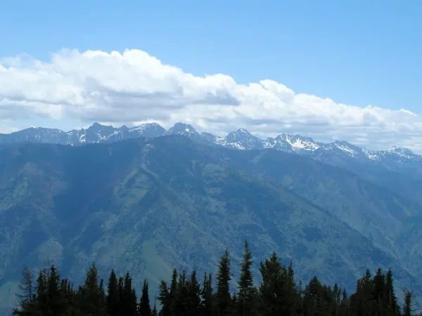
Across the Snake River and the Oregon/Idaho border lie the Seven Devils Mountains. An extinct volcanic range, the Seven Devils comprise the western most chain of the Rocky Mountains. With peaks as high as 9300 ft, the Seven Devils hold mountain goats, spectacular summer wildflower blooms, and over 90 alpine lakes. You can see these snow-capped peaks from the Hells Canyon Overlook. [US Forest Service]
North Pine Creek / ~ mile 32
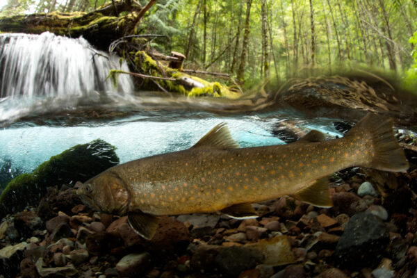
Bull trout are a native Pacific Northwest migratory fish and are primarily found in high mountainous areas. The Four Cs – cold, clean, complex, and connected habitats – are crucial to the habitat requirements of bull trout. However, the construction of significant dams such as Brownlee and Oxbow on the Snake River has limited their distribution in the Hells Canyon Region and hindered connectivity between populations. Several segments of the bull trout population, including the Pine Creek population, are dwindling in numbers due to habitat degradation, resulting in the designation of bull trout as a Threatened species in the contiguous United States under the Endangered Species Act. [ODFW]
When We Like to Ride This
During the summer we like this route mid-week, with an early start. This is to avoid some of the summer tourist traffic. Fall, beyond Labor Day is also a great time to give this route a go.
Note, the Hells Canyon Scenic Byway (the paved sector of the route) is usually closed due to snow from late October through late May or early June. For updates on road closures and access to the Hells Canyon Lookout, check out the Hells Canyon Byway website.
Terrain & Riding
The Terrain
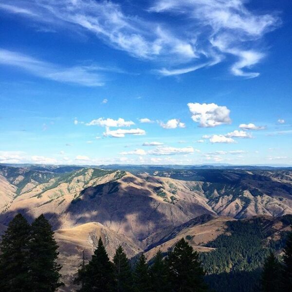
Hells Canyon offers an awe-inspiring landscape that is a must-visit, must-see. The canyon itself, carved by the meandering Snake River, boasts the title of the deepest river gorge in North America at 7,993 feet (deeper than the Grand Canyon), with staggering walls that reveal eons of geological history.
The geologic history of the rocks of Hells Canyon begins 300 million years ago with an arc of volcanoes that emerged from the waters of the Pacific Ocean. Over million of years, the volcanoes subsided and limestone built up on the underwater platforms. The basins between them were filled with sedimentary rock. Between 130 and 17 million years ago, the ocean plate carrying the volcanoes collided with and became part of the North American continent. A period of volcanic activity followed, and much of the area was covered with floods of basalt lava, which smoothed the topography into a high plateau. The Snake River began carving Hells Canyon out of the plateau about 6 million years ago. Significant canyon-shaping events occurred as recently as 15,000 years ago during a massive outburst flood from Glacial Lake Bonneville in Utah. [NASA Earth Observatory]
As you ascend from the arid lower reaches of the canyon, the vegetation undergoes a striking transformation. The sparse grasses and sagebrush give way to dense forests of Ponderosa pines, with Douglas firs making an appearance as you approach the higher elevations. The surrounding Wallowa Mountains, which cradle the canyon, are a picturesque ensemble of high peaks, alpine meadows, and valleys sculpted by ancient glaciers. This area is rich in biodiversity, and it’s not uncommon to spot bighorn sheep, deer, eagles, and an array of other wildlife.
The climate within Hells Canyon varies with elevation; the canyon floor can be scorching in the summer, while the surrounding peaks are blanketed with snow in the winter.
The Riding
The highlight (hmmm??) of this route is a heart-pounding 7-mile gravel climb with an average gradient of 10%, the rest of the route is pleasantly moderate, making it an enticing endeavor for avid cyclists. Note that gravel only accounts for 30% of the entire route.
Kick-start your adventure with a serene 6.9-mile descent along a paved road that gently slopes at a 1-2% gradient, guiding you through a small quaint canyon alongside the Pine Creek, right up to the charming hamlet of Oxbow. Here, the mighty Snake River greets you with open arms. Pause for a moment to marvel at the Oxbow Dam, acquaint yourself with the aquatic residents at the fish hatchery, and immerse yourself in the sheer beauty of your surroundings.
As you leave Oxbow behind, get ready to embrace the gravel! The next 6 miles are a cyclist’s dream as you traverse an old railbed that’s been reborn as a road. Here, the river becomes your intimate companion, with the terrain playfully rising and falling for a total gain and loss of 210 feet.
Now, the moment of truth! At approximately 13.5 miles in, Hess Road beckons. With jaw-dropping vistas to reward your efforts and a merciless gradient to challenge your mettle, the next 7 miles demand your all as you climb a staggering 3,800 feet. Steep sections test your grit with short pitches exceeding 15%. But worry not, for the route eventually turns merciful, and within 2.5 miles from the summit, you are welcomed by a tranquil forest as the road’s incline mellows to a more manageable 5-6%.
The whispers of the trees and the dappled sunlight are a refreshing antidote to the open expanse that preceded it – a welcome respite on a sizzling summer day.
Around the 20.5-mile mark, you’ll find yourself back on the pavement. A short dogleg out to the viewpoint is absolutely worth the extra pedal strokes. This dogleg ebbs and flows, gaining 550 feet and losing 350 feet. Once there, let your soul be enveloped by panoramic vistas and delve into the history and geology of the area through informative kiosks.
Time to loop back! The return journey along the dogleg is more forgiving, with gravity on your side. As you hit the 28-mile mark, let the downhill you as North Pine Creek leads you back to where you began. A gentle reminder – stay vigilant for uphill traffic and remain in your lane.
The Start
A makeshift dirt pull-out on the side of North Pine Road where it intersects State Highway 86.
Food & Water
- ~ mile 7 / Town of Oxbow
- ~ mile 38 / Lake Fork Campground. Seasonal well water.
Route Notes
For the paved sectors, we strongly recommend a red blinky light with rear looking radar detector like a Garmin Varia.
For the first paved sector, we strongly recommend riding single-file as this will be the busiest road of the day and has limited sight-lines. An early start will help you avoid some of the traffic. For the downhill paved sector from the Hells Canyon Viewpoint, expect uphill vehicle traffic and stay within your lane for safety.
Route Options
Out and back on pavement on to the Hells Canyon Overlook, a great place to snap photos.
Another tough, demanding, but awe-inspiring route is Kleinschmidt Grade (yet to be published), on the Idaho side of the Snake River.
Love Where You Ride! Learn More
 At 7,993 feet deep, Hells Canyon is North America’s deepest river gorge. The greater Hells Canyon region is the hub of three great eco-regions, from high alpine lakes in the surrounding mountains to the dry and rocky slopes along the Snake River. This diversity in bio-regions is integral for climate change resiliency for species as they adapt, and ultimately survive, the changing climate. As a migration corridor for a multitude of species, the greater Hells Canyon region allows them to migrate up and down in elevation, as well as up and down in latitude. To learn more about how you can get involved in protecting this rich environment, visit the Greater Hells Canyon Council’s website.
Videos
Greater Hells Canyon Region
This video highlights the importance of the Greater Hells Canyon Region for wildlife migration and climate resiliency. This special place is located in NE Oregon, right on the Idaho border.
Fern Hobbs
Meet the remarkable woman Fern Hobbs, Oregon Governor Oswald West's private secretary who was sent on a mission on New Year’s Day 1914 to shut down the lawless town of Copperfield on the Snake River. This is a biography of one of the most courageous and important women of early Oregon [...]
Clipping Fins!
Wildlife technicians use various methods to clip adipose fins so that anglers can differentiate between wild and hatchery salmon. In this 2-minute video, learn what is an [...]
Keep it Local! Learn More

 Behind every route is scouting, mapping, storytelling, and a whole lot of pedal power.
Have you ridden this route? Got a question? Join the discussion!